Estimated Value: $247,000 - $299,397
--
Bed
--
Bath
960
Sq Ft
$279/Sq Ft
Est. Value
About This Home
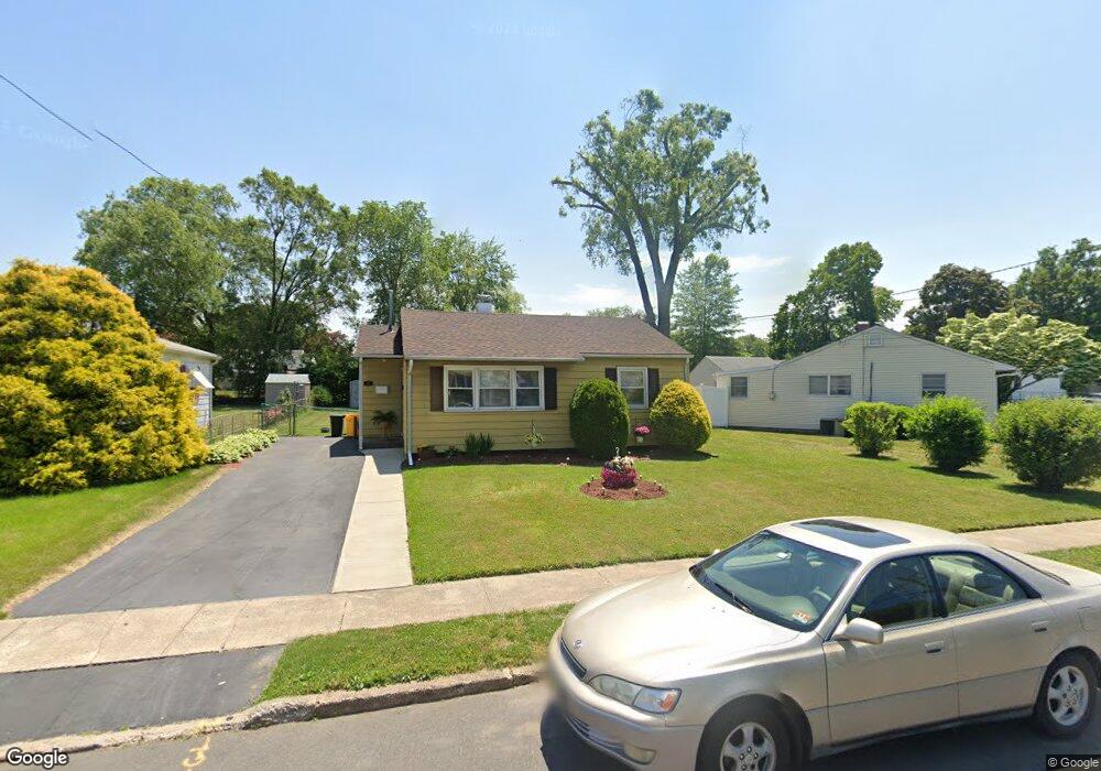
This home is located at 14 Gilmore Rd, Ewing, NJ 08628 and is currently estimated at $267,849, approximately $279 per square foot. 14 Gilmore Rd is a home located in Mercer County with nearby schools including Ewing High School, The Village Charter School, and Christina Seix Academy.
Ownership History
Date
Name
Owned For
Owner Type
Purchase Details
Closed on
Nov 26, 2002
Sold by
Parrish Clarence
Bought by
Hill Cathy
Current Estimated Value
Home Financials for this Owner
Home Financials are based on the most recent Mortgage that was taken out on this home.
Original Mortgage
$130,529
Outstanding Balance
$55,180
Interest Rate
6.02%
Estimated Equity
$212,669
Purchase Details
Closed on
May 20, 2002
Sold by
Neall Scott
Bought by
Parrish Clarence and Parrish Viviane
Home Financials for this Owner
Home Financials are based on the most recent Mortgage that was taken out on this home.
Original Mortgage
$110,146
Interest Rate
7.01%
Mortgage Type
FHA
Create a Home Valuation Report for This Property
The Home Valuation Report is an in-depth analysis detailing your home's value as well as a comparison with similar homes in the area
Home Values in the Area
Average Home Value in this Area
Purchase History
| Date | Buyer | Sale Price | Title Company |
|---|---|---|---|
| Hill Cathy | $132,600 | -- | |
| Parrish Clarence | $120,000 | -- |
Source: Public Records
Mortgage History
| Date | Status | Borrower | Loan Amount |
|---|---|---|---|
| Open | Hill Cathy | $130,529 | |
| Previous Owner | Parrish Clarence | $110,146 |
Source: Public Records
Tax History Compared to Growth
Tax History
| Year | Tax Paid | Tax Assessment Tax Assessment Total Assessment is a certain percentage of the fair market value that is determined by local assessors to be the total taxable value of land and additions on the property. | Land | Improvement |
|---|---|---|---|---|
| 2025 | $5,022 | $127,700 | $54,900 | $72,800 |
| 2024 | $4,721 | $127,700 | $54,900 | $72,800 |
| 2023 | $4,721 | $127,700 | $54,900 | $72,800 |
| 2022 | $4,593 | $127,700 | $54,900 | $72,800 |
| 2021 | $4,481 | $127,700 | $54,900 | $72,800 |
| 2020 | $4,417 | $127,700 | $54,900 | $72,800 |
| 2019 | $4,302 | $127,700 | $54,900 | $72,800 |
| 2018 | $4,183 | $79,200 | $47,000 | $32,200 |
| 2017 | $4,281 | $79,200 | $47,000 | $32,200 |
| 2016 | $4,223 | $79,200 | $47,000 | $32,200 |
| 2015 | $4,167 | $79,200 | $47,000 | $32,200 |
| 2014 | $4,156 | $79,200 | $47,000 | $32,200 |
Source: Public Records
Map
Nearby Homes
- 161 Franklyn Rd
- 152 Franklyn Rd
- 322 Wynnewood Rd
- 409 Silvia St
- 325 Silvia St
- 335 Silvia St
- 288 Clamer Rd
- 860 Lower Ferry Rd Unit 2K
- 860 Lower Ferry Rd Unit 1K
- 1200 Silvia St
- 528 Mrtn King Jr
- 624 Mrtn King Jr
- 21 Dixmont Ave
- 30 Chelmsford Ct
- 1060 Terrace Blvd
- 115 Stratford Ave
- 21 Decou Ave
- 3 Wallace Ave
- 15 Decou Ave
- 51 Farrell Ave