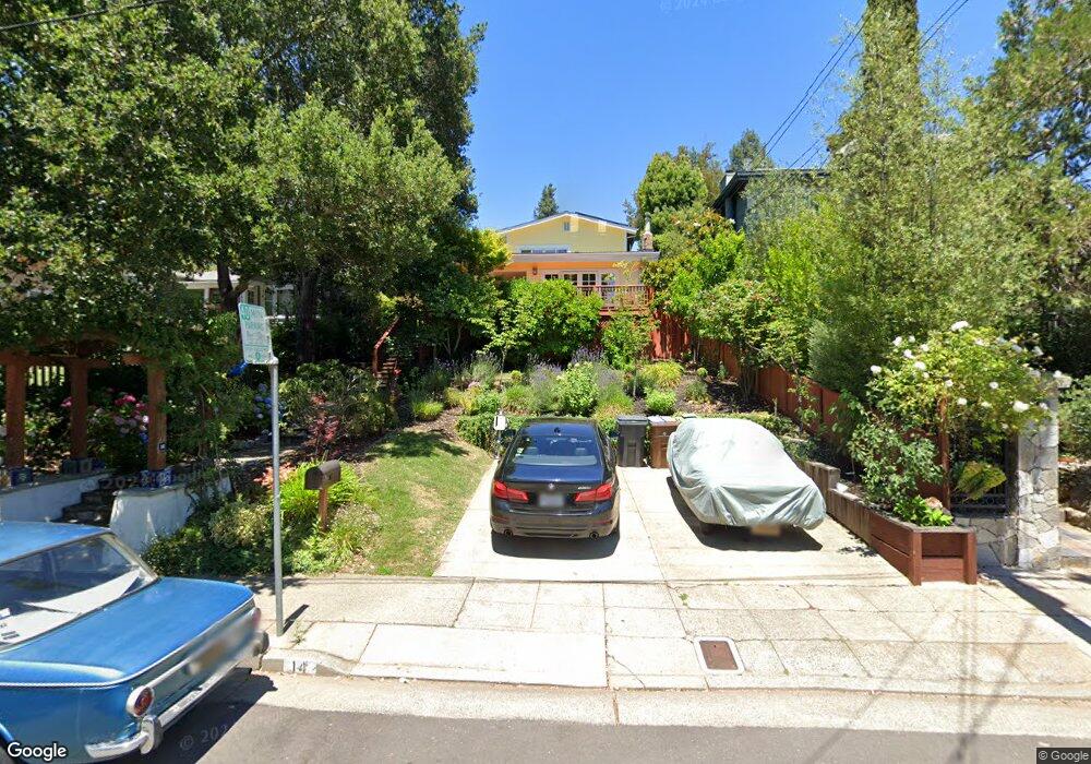
14 Locust Ave Kentfield, CA 94904
Estimated Value: $2,125,000 - $2,241,693
3
Beds
3
Baths
2,380
Sq Ft
$912/Sq Ft
Est. Value
About This Home
This home is located at 14 Locust Ave, Kentfield, CA 94904 and is currently estimated at $2,169,673, approximately $911 per square foot. 14 Locust Ave is a home located in Marin County with nearby schools including Anthony G. Bacich Elementary School, Adaline E. Kent Middle School, and Redwood High School.
Ownership History
Date
Name
Owned For
Owner Type
Purchase Details
Closed on
Nov 14, 1995
Sold by
Smith Averell and Talmus Laura
Bought by
Smith Averell and Talmus Laura
Current Estimated Value
Create a Home Valuation Report for This Property
The Home Valuation Report is an in-depth analysis detailing your home's value as well as a comparison with similar homes in the area
Home Values in the Area
Average Home Value in this Area
Purchase History
| Date | Buyer | Sale Price | Title Company |
|---|---|---|---|
| Smith Averell | -- | -- |
Source: Public Records
Tax History
| Year | Tax Paid | Tax Assessment Tax Assessment Total Assessment is a certain percentage of the fair market value that is determined by local assessors to be the total taxable value of land and additions on the property. | Land | Improvement |
|---|---|---|---|---|
| 2025 | $14,915 | $915,878 | $309,440 | $606,438 |
| 2024 | $14,169 | $897,920 | $303,373 | $594,547 |
| 2023 | $13,850 | $880,315 | $297,424 | $582,891 |
| 2022 | $13,721 | $863,056 | $291,593 | $571,463 |
| 2021 | $13,451 | $846,135 | $285,876 | $560,259 |
| 2020 | $13,245 | $837,460 | $282,945 | $554,515 |
| 2019 | $12,764 | $821,039 | $277,397 | $543,642 |
| 2018 | $12,342 | $804,941 | $271,958 | $532,983 |
| 2017 | $11,623 | $789,160 | $266,626 | $522,534 |
| 2016 | $11,227 | $773,689 | $261,399 | $512,290 |
| 2015 | $11,156 | $762,071 | $257,474 | $504,597 |
| 2014 | $10,549 | $747,143 | $252,430 | $494,713 |
Source: Public Records
Map
Nearby Homes
- 31 Ross Terrace
- 21 Hillside Ave
- 96 Laurel Grove Ave
- 11 Ash Ave
- 4 Ash Ave Unit 15
- 4 Ash Ave Unit 11
- 80 Laurel Grove Ave
- 101 Laurel Grove Ave
- 37 Rosebank Ave
- 161 Lagunitas Rd
- 14 Sylvan Ln
- 22 Rock Rd
- 85 Berens Dr
- 33 Acorn Way
- 1 Lilac Ave
- 17 Redwood Dr
- 450 Woodland Rd
- 100 Black Log Rd
- 90 Upper Briar Rd
- 42 Grove St
- 16 Locust Ave
- 12 Locust Ave
- 10 Locust Ave
- 18 Locust Ave
- 1105 Sir Francis Drake Blvd
- 1107 Sir Francis Drake Blvd
- 20 Locust Ave
- 18 Cedar Ave
- 15 Locust Ave
- 9 Locust Ave
- 7 Locust Ave
- 1101 Sir Francis Drake Blvd
- 22 Locust Ave
- 5 Locust Ave
- 6 Locust Ave
- 1115 Sir Francis Drake Blvd Unit 1115 Francis Drake B
- 1115 Sir Francis Drake Blvd
- 14 Cedar Ave
- 8 Laurel Ave
Your Personal Tour Guide
Ask me questions while you tour the home.