K
Seller's Agent in 2025
Kathleen Bryan
Park Place Realty Enterprises
(508) 450-0030
1 in this area
19 Total Sales
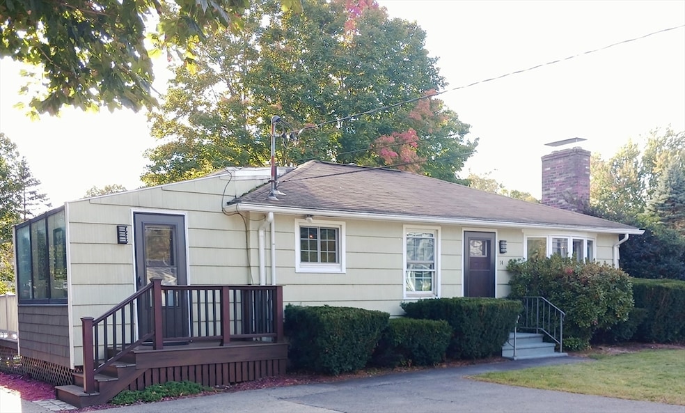

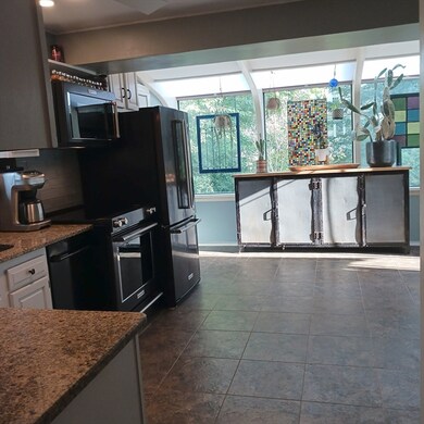


Hard to find "ONE LEVEL LIVING" with a bonus partially finish basement! As soon as you walk into this home, you will be wowed by the bright kitchen w/newer appliances (less then 2 yrs old) and granite countertops! Nice dining area w/stunning lighting. Cozy living room w/working fireplace for those chilly New England winters. Gleaming hardwoods throughout! Recent updated bathroom with heated tile flooring and custom vanity! Back deck w/lots of room for entertaining! The yard is more like an oasis! It begins with a tranquil seating area right in front of Gates brook! The abundant yard is perfectly landscaped w/patio area for some outdoor fires!Huge shed for storing. Apple & pear trees, the list goes on! The basement includes 2 finished rooms for endless possibilities and another area for lots of storage!Some of the basement windows have been updated!Recent updates:Electric panel updated (1yr)Water filtration system (3yr),Hot water tank (4yr)-Retractable hose (6 Months) This won't last!
| Date | Type | Sale Price | Title Company |
|---|---|---|---|
| Quit Claim Deed | $431,500 | -- | |
| Deed | -- | -- | |
| Deed | $186,500 | -- | |
| Deed | $186,500 | -- | |
| Deed | $126,000 | -- |
| Date | Status | Loan Amount | Loan Type |
|---|---|---|---|
| Open | $406,600 | Purchase Money Mortgage | |
| Previous Owner | $185,867 | FHA | |
| Previous Owner | $183,121 | Purchase Money Mortgage | |
| Previous Owner | $21,000 | Purchase Money Mortgage |
| Date | Event | Price | List to Sale | Price per Sq Ft |
|---|---|---|---|---|
| 10/28/2025 10/28/25 | Sold | $431,500 | +7.9% | $468 / Sq Ft |
| 09/24/2025 09/24/25 | Pending | -- | -- | -- |
| 09/21/2025 09/21/25 | For Sale | $399,900 | -- | $434 / Sq Ft |
| Year | Tax Paid | Tax Assessment Tax Assessment Total Assessment is a certain percentage of the fair market value that is determined by local assessors to be the total taxable value of land and additions on the property. | Land | Improvement |
|---|---|---|---|---|
| 2025 | $47 | $335,400 | $96,800 | $238,600 |
| 2024 | $4,620 | $312,600 | $96,800 | $215,800 |
| 2023 | $4,484 | $287,800 | $96,200 | $191,600 |
| 2022 | $4,303 | $243,400 | $96,200 | $147,200 |
| 2021 | $4,196 | $227,300 | $92,600 | $134,700 |
| 2020 | $4,132 | $222,400 | $92,600 | $129,800 |
| 2019 | $3,909 | $207,400 | $92,600 | $114,800 |
| 2018 | $3,751 | $200,400 | $92,600 | $107,800 |
| 2017 | $3,395 | $180,600 | $92,600 | $88,000 |
| 2016 | $3,321 | $180,000 | $86,300 | $93,700 |
| 2015 | $3,257 | $177,600 | $85,400 | $92,200 |
K
Seller's Agent in 2025
Kathleen Bryan
Park Place Realty Enterprises
(508) 450-0030
1 in this area
19 Total Sales

Buyer's Agent in 2025
Carl Cempe
StartPoint Realty
(508) 272-2794
1 in this area
105 Total Sales
Source: MLS Property Information Network (MLS PIN)
MLS Number: 73433798
APN: WBOY-000152-000009
Disclaimer: Certain information contained herein is derived from information provided by parties other than Homes.com. All information provided is deemed reliable, but is not guaranteed to be accurate and should be independently verified.
![]() The property listing data and information, or the Images, set forth herein were provided to MLS Property Information Network, Inc. from third party sources, including sellers, lessors and public records, and were compiled by MLS Property Information Network, Inc. The property listing data and information, and the Images, are for the personal, non-commercial use of consumers having a good faith interest in purchasing or leasing listed properties of the type displayed to them and may not be used for any purpose other than to identify prospective properties which such consumers may have a good faith interest in purchasing or leasing. MLS Property Information Network, Inc. and its subscribers disclaim any and all representations and warranties as to the accuracy of the property listing data and information, or as to the accuracy of any of the Images, set forth herein.
The property listing data and information, or the Images, set forth herein were provided to MLS Property Information Network, Inc. from third party sources, including sellers, lessors and public records, and were compiled by MLS Property Information Network, Inc. The property listing data and information, and the Images, are for the personal, non-commercial use of consumers having a good faith interest in purchasing or leasing listed properties of the type displayed to them and may not be used for any purpose other than to identify prospective properties which such consumers may have a good faith interest in purchasing or leasing. MLS Property Information Network, Inc. and its subscribers disclaim any and all representations and warranties as to the accuracy of the property listing data and information, or as to the accuracy of any of the Images, set forth herein.
Ask me questions while you tour the home.