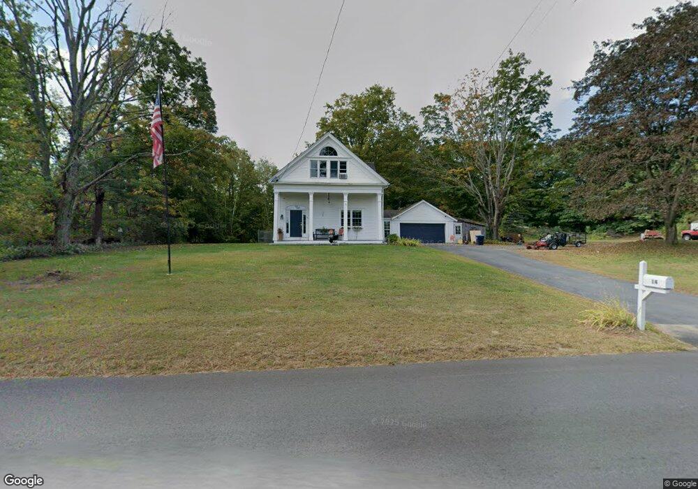
14 Pratts Junction Rd Sterling, MA 01564
Estimated Value: $471,364 - $536,000
3
Beds
2
Baths
1,715
Sq Ft
$300/Sq Ft
Est. Value
About This Home
This home is located at 14 Pratts Junction Rd, Sterling, MA 01564 and is currently estimated at $514,591, approximately $300 per square foot. 14 Pratts Junction Rd is a home located in Worcester County with nearby schools including Wachusett Regional High School, St. Anna Catholic School, and St. Leo School.
Ownership History
Date
Name
Owned For
Owner Type
Purchase Details
Closed on
Sep 29, 2000
Sold by
Knorr David J and Lagasse-Knorr Ellen
Bought by
Fiske Timothy W and Fiske Deborah L
Current Estimated Value
Home Financials for this Owner
Home Financials are based on the most recent Mortgage that was taken out on this home.
Original Mortgage
$181,391
Interest Rate
7.94%
Mortgage Type
Purchase Money Mortgage
Create a Home Valuation Report for This Property
The Home Valuation Report is an in-depth analysis detailing your home's value as well as a comparison with similar homes in the area
Home Values in the Area
Average Home Value in this Area
Purchase History
| Date | Buyer | Sale Price | Title Company |
|---|---|---|---|
| Fiske Timothy W | $182,900 | -- |
Source: Public Records
Mortgage History
| Date | Status | Borrower | Loan Amount |
|---|---|---|---|
| Open | Fiske Timothy W | $180,470 | |
| Closed | Fiske Timothy W | $181,391 |
Source: Public Records
Tax History
| Year | Tax Paid | Tax Assessment Tax Assessment Total Assessment is a certain percentage of the fair market value that is determined by local assessors to be the total taxable value of land and additions on the property. | Land | Improvement |
|---|---|---|---|---|
| 2025 | $4,961 | $385,200 | $123,200 | $262,000 |
| 2024 | $4,983 | $374,400 | $123,200 | $251,200 |
| 2023 | $4,453 | $311,400 | $124,100 | $187,300 |
| 2022 | $4,060 | $266,200 | $112,700 | $153,500 |
| 2021 | $11,777 | $258,400 | $110,500 | $147,900 |
| 2020 | $3,836 | $228,200 | $108,000 | $120,200 |
| 2019 | $4,152 | $240,400 | $108,000 | $132,400 |
| 2018 | $6,043 | $196,000 | $103,400 | $92,600 |
| 2017 | $3,478 | $192,900 | $99,400 | $93,500 |
| 2016 | $3,910 | $213,300 | $99,400 | $113,900 |
| 2015 | $3,621 | $209,400 | $93,700 | $115,700 |
| 2014 | $3,689 | $217,900 | $88,400 | $129,500 |
Source: Public Records
Map
Nearby Homes
- 2 Turtle Ln Unit 2
- 121 &125 Flanagan Hill Rd
- 134 Leominster Rd
- 6A Patriots Way Unit 37
- 675 Willard St
- 90 Tuttle Rd
- 96 Clinton Rd
- 23 Lantern Ln
- 103 Keeneland Cir
- 193 Bayberry Hill Ln
- 5 Pine Woods Ln
- 40 Biscayne St
- 2290 Main St
- 372 Litchfield St
- 851 Lancaster St
- 6 Chapman Place
- 30 Abbey Rd Unit 202
- 45 Neylon St
- 25 Meadow Pond Dr Unit j
- 18 Highfield Dr
- 20 Pratts Junction Rd
- 8 Pratts Junction Rd
- 24 Pratts Junction Rd
- 26 Pratts Junction Rd
- 26 Pratts Junction Rd Unit A
- 6 Pratts Junction Rd
- Lot 1a Legate Hill Rd
- 247 Leominster Rd
- 243 Leominster Rd
- 32 Pratts Junction Rd
- 1 Legate Hill Rd
- 30 Pratts Junction Rd
- 30-32 Pratts Jct Rd
- 253 Leominster Rd
- lot 4 Pratts Jct Rd
- lot 3 Pratts Jct Rd
- 251 Leominster Rd
- Lot 1 N Row Rd
- 258 Leominster Rd
- 233 Leominster Rd
Your Personal Tour Guide
Ask me questions while you tour the home.