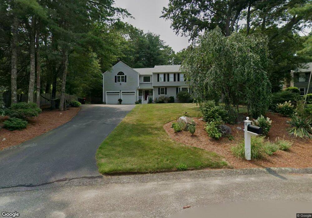
14 Strawstone Ln Norton, MA 02766
Estimated Value: $741,707 - $888,000
5
Beds
3
Baths
2,392
Sq Ft
$328/Sq Ft
Est. Value
About This Home
This home is located at 14 Strawstone Ln, Norton, MA 02766 and is currently estimated at $785,427, approximately $328 per square foot. 14 Strawstone Ln is a home located in Bristol County with nearby schools including J.C. Solmonese Elementary School, Henri A. Yelle Elementary School, and Norton Middle School.
Ownership History
Date
Name
Owned For
Owner Type
Purchase Details
Closed on
Apr 30, 1996
Sold by
Tellen Brain K and Tellen Carolyn W
Bought by
Lerner Adam R and Fitzgerald Stephanie M
Current Estimated Value
Purchase Details
Closed on
Jul 29, 1991
Sold by
Straw Stone Rt
Bought by
Tellen Brian K and Tellen Carolyn W
Create a Home Valuation Report for This Property
The Home Valuation Report is an in-depth analysis detailing your home's value as well as a comparison with similar homes in the area
Home Values in the Area
Average Home Value in this Area
Purchase History
| Date | Buyer | Sale Price | Title Company |
|---|---|---|---|
| Lerner Adam R | $175,000 | -- | |
| Tellen Brian K | $149,900 | -- |
Source: Public Records
Mortgage History
| Date | Status | Borrower | Loan Amount |
|---|---|---|---|
| Open | Tellen Brian K | $295,000 | |
| Closed | Tellen Brian K | $260,000 |
Source: Public Records
Tax History
| Year | Tax Paid | Tax Assessment Tax Assessment Total Assessment is a certain percentage of the fair market value that is determined by local assessors to be the total taxable value of land and additions on the property. | Land | Improvement |
|---|---|---|---|---|
| 2025 | $83 | $639,700 | $219,900 | $419,800 |
| 2024 | $7,850 | $606,200 | $209,400 | $396,800 |
| 2023 | $7,430 | $572,000 | $197,500 | $374,500 |
| 2022 | $7,234 | $507,300 | $179,500 | $327,800 |
| 2021 | $5,252 | $462,600 | $171,000 | $291,600 |
| 2020 | $6,650 | $449,300 | $166,000 | $283,300 |
| 2019 | $5,218 | $430,000 | $159,700 | $270,300 |
| 2018 | $6,361 | $419,600 | $159,700 | $259,900 |
| 2017 | $6,153 | $400,300 | $159,700 | $240,600 |
| 2016 | $5,913 | $378,800 | $159,700 | $219,100 |
| 2015 | $5,742 | $373,100 | $156,500 | $216,600 |
| 2014 | $5,466 | $355,600 | $149,100 | $206,500 |
Source: Public Records
Map
Nearby Homes
- 2 Oak St Unit 2B
- 143 Oak St Unit 10
- 451R Gilbert St
- 71 Richardson Ave
- 44 Surrey Dr
- 10 Anna Way
- 5 Village Way Unit C
- 343 Godfrey Dr
- 101 Godfrey Dr Unit 101
- 250 Mansfield Ave Unit 11
- 17 Village Way Unit F
- 14 Claire Ave
- 345 Richardson Ave
- 157 Mansfield Ave Unit 27
- 157 Mansfield Ave Unit 14
- 49 Pheasant Hill Rd
- 150 Gilbert St
- 933 Pleasant St
- 5 Robin Cir Unit 5
- 123 Pike Ave
- 16 Strawstone Ln
- 12 Strawstone Ln
- 18 Strawstone Ln
- 3 Strawstone Ln
- 10 Strawstone Ln
- 9 Stony Field Rd
- 20 Strawstone Ln
- 15 Stony Field Rd
- 5 Strawstone Ln
- 13 Stony Field Rd
- 1 Strawstone Ln
- 11 Stony Field Rd
- 17 Stony Field Rd
- 7 Stony Field Rd
- 47 Crestwood Dr
- 8 Strawstone Ln
- 6 Brookwood Ln
- 12 Stony Field Rd
- 5 Brookwood Ln
- 10 Stony Field Rd
Your Personal Tour Guide
Ask me questions while you tour the home.