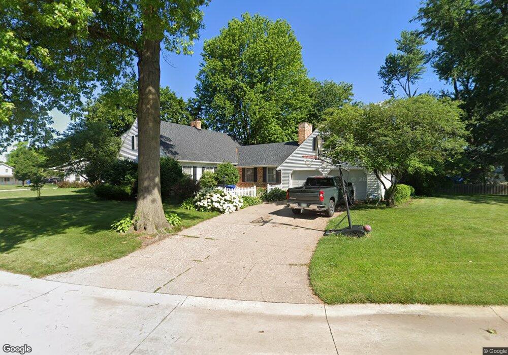
14 Sunset Cir Bettendorf, IA 52722
Downtown Bettendorf NeighborhoodEstimated Value: $386,000 - $418,000
4
Beds
3
Baths
2,346
Sq Ft
$173/Sq Ft
Est. Value
About This Home
This home is located at 14 Sunset Cir, Bettendorf, IA 52722 and is currently estimated at $406,168, approximately $173 per square foot. 14 Sunset Cir is a home located in Scott County with nearby schools including Neil Armstrong Elementary School, Bettendorf Middle School, and Bettendorf High School.
Ownership History
Date
Name
Owned For
Owner Type
Purchase Details
Closed on
Mar 28, 2016
Sold by
Gillette Aaron B and Gillette Meg E
Bought by
Ward Patrick L and Ward Gina M
Current Estimated Value
Home Financials for this Owner
Home Financials are based on the most recent Mortgage that was taken out on this home.
Original Mortgage
$278,910
Outstanding Balance
$220,536
Interest Rate
3.62%
Mortgage Type
VA
Estimated Equity
$185,632
Purchase Details
Closed on
May 27, 2009
Sold by
West Patricia A
Bought by
Gillette Aaron B and Gillette Meg E
Home Financials for this Owner
Home Financials are based on the most recent Mortgage that was taken out on this home.
Original Mortgage
$156,000
Interest Rate
4.84%
Mortgage Type
Purchase Money Mortgage
Create a Home Valuation Report for This Property
The Home Valuation Report is an in-depth analysis detailing your home's value as well as a comparison with similar homes in the area
Home Values in the Area
Average Home Value in this Area
Purchase History
| Date | Buyer | Sale Price | Title Company |
|---|---|---|---|
| Ward Patrick L | -- | None Available | |
| Gillette Aaron B | $226,000 | None Available |
Source: Public Records
Mortgage History
| Date | Status | Borrower | Loan Amount |
|---|---|---|---|
| Open | Ward Patrick L | $278,910 | |
| Previous Owner | Gillette Aaron B | $156,000 |
Source: Public Records
Tax History Compared to Growth
Tax History
| Year | Tax Paid | Tax Assessment Tax Assessment Total Assessment is a certain percentage of the fair market value that is determined by local assessors to be the total taxable value of land and additions on the property. | Land | Improvement |
|---|---|---|---|---|
| 2025 | $5,908 | $447,100 | $76,300 | $370,800 |
| 2024 | $5,856 | $400,700 | $46,300 | $354,400 |
| 2023 | $5,396 | $400,700 | $46,300 | $354,400 |
| 2022 | $5,338 | $318,770 | $46,270 | $272,500 |
| 2021 | $5,338 | $318,770 | $46,270 | $272,500 |
| 2020 | $4,814 | $277,470 | $46,270 | $231,200 |
| 2019 | $4,836 | $270,740 | $46,270 | $224,470 |
| 2018 | $4,832 | $270,740 | $46,270 | $224,470 |
| 2017 | $1,487 | $270,740 | $46,270 | $224,470 |
| 2016 | $4,482 | $249,020 | $0 | $0 |
| 2015 | $4,482 | $238,620 | $0 | $0 |
| 2014 | $4,342 | $237,520 | $0 | $0 |
| 2013 | $4,224 | $0 | $0 | $0 |
| 2012 | -- | $239,850 | $41,110 | $198,740 |
Source: Public Records
Map
Nearby Homes
- 1910 Bellevue Ave
- 2211 Central Ave
- 452 21st St
- 2007 Mississippi Blvd
- 605 16th St
- 2340 Oak St
- 2505 Cody St
- 1834 Anderson Ct
- 1424 23rd St
- 17 Wildwood Trail
- 1316 Glencoe Ln
- 2506 Bayberry Ct
- 16 Wildwood Trail
- 1522 25th St
- 906 28th 1 2 St
- 821 Ten Plus St
- 3970 Orchard Dr
- 2918 Oak St
- 1705 Elmwood Dr
- 1037 Holmes St