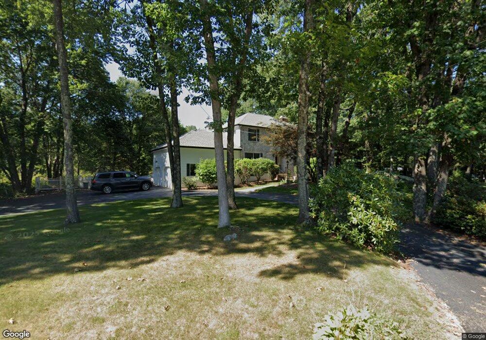
14 Woodside Cir Sturbridge, MA 01566
Estimated Value: $633,549 - $754,000
4
Beds
3
Baths
2,424
Sq Ft
$284/Sq Ft
Est. Value
About This Home
This home is located at 14 Woodside Cir, Sturbridge, MA 01566 and is currently estimated at $688,137, approximately $283 per square foot. 14 Woodside Cir is a home located in Worcester County with nearby schools including Burgess Elementary School, Tantasqua Regional Junior High School, and Tantasqua Regional High School.
Ownership History
Date
Name
Owned For
Owner Type
Purchase Details
Closed on
Oct 28, 2009
Sold by
Roncaioli Charles J and Roncaioli Janice L
Bought by
Borowski Donald P and Borowski Jean M
Current Estimated Value
Home Financials for this Owner
Home Financials are based on the most recent Mortgage that was taken out on this home.
Original Mortgage
$292,800
Outstanding Balance
$191,773
Interest Rate
5.06%
Mortgage Type
Purchase Money Mortgage
Estimated Equity
$496,364
Purchase Details
Closed on
Oct 18, 1999
Sold by
Amirault Nelson L and Amirault Patricia C
Bought by
Roncaioli Charles J and Roncaioli Janice L
Create a Home Valuation Report for This Property
The Home Valuation Report is an in-depth analysis detailing your home's value as well as a comparison with similar homes in the area
Home Values in the Area
Average Home Value in this Area
Purchase History
| Date | Buyer | Sale Price | Title Company |
|---|---|---|---|
| Borowski Donald P | $366,000 | -- | |
| Roncaioli Charles J | $277,500 | -- |
Source: Public Records
Mortgage History
| Date | Status | Borrower | Loan Amount |
|---|---|---|---|
| Open | Borowski Donald P | $292,800 |
Source: Public Records
Tax History Compared to Growth
Tax History
| Year | Tax Paid | Tax Assessment Tax Assessment Total Assessment is a certain percentage of the fair market value that is determined by local assessors to be the total taxable value of land and additions on the property. | Land | Improvement |
|---|---|---|---|---|
| 2025 | $9,340 | $586,300 | $114,200 | $472,100 |
| 2024 | $9,160 | $555,500 | $111,800 | $443,700 |
| 2023 | $8,910 | $493,100 | $97,100 | $396,000 |
| 2022 | $8,583 | $448,200 | $87,700 | $360,500 |
| 2021 | $7,829 | $411,600 | $83,600 | $328,000 |
| 2020 | $7,829 | $411,600 | $83,600 | $328,000 |
| 2019 | $7,329 | $382,700 | $86,000 | $296,700 |
| 2018 | $7,220 | $371,400 | $81,800 | $289,600 |
| 2017 | $6,889 | $355,100 | $78,900 | $276,200 |
| 2016 | $6,599 | $343,500 | $76,500 | $267,000 |
Source: Public Records
Map
Nearby Homes
- 51-A Seneca Ln
- 43 Mountain Brook Rd
- 50 Beach Ave
- 22 Mountain Brook Rd
- 6 Cedar Pond Dr
- 6 Jerry Rd
- 2 Sprucedale Dr
- 73 New Boston Rd
- 24 Cricket Dr
- 146-A. Cedar St
- 146-A Cedar St
- 20 Audubon Way
- 7 Crescent Way Unit 315
- 368 Main St
- 7 Meadow View Ln
- 213 Cedar St
- 7 Haynes St
- 9 Haynes St
- 76 Stallion Hill Rd
- 621 Main St
- 18 Woodside Cir
- 15 Woodside Cir
- 13 Woodside Cir
- 17 Woodside Cir
- 20 Woodside Cir
- 19 Woodside Cir
- 8 Woodside Cir
- 8 Woodside Cir Unit 1
- 6 Woodside Cir
- 11 Woodside Cir
- 21 Woodside Cir
- 24 Woodside Cir
- 4 Woodside Cir
- 23 Woodside Cir
- 9 Woodside Cir
- 7 Woodside Cir
- 26 Woodside Cir
- 3 Woodside Cir
- 3 Woodside Cir
- 2 Woodside Cir