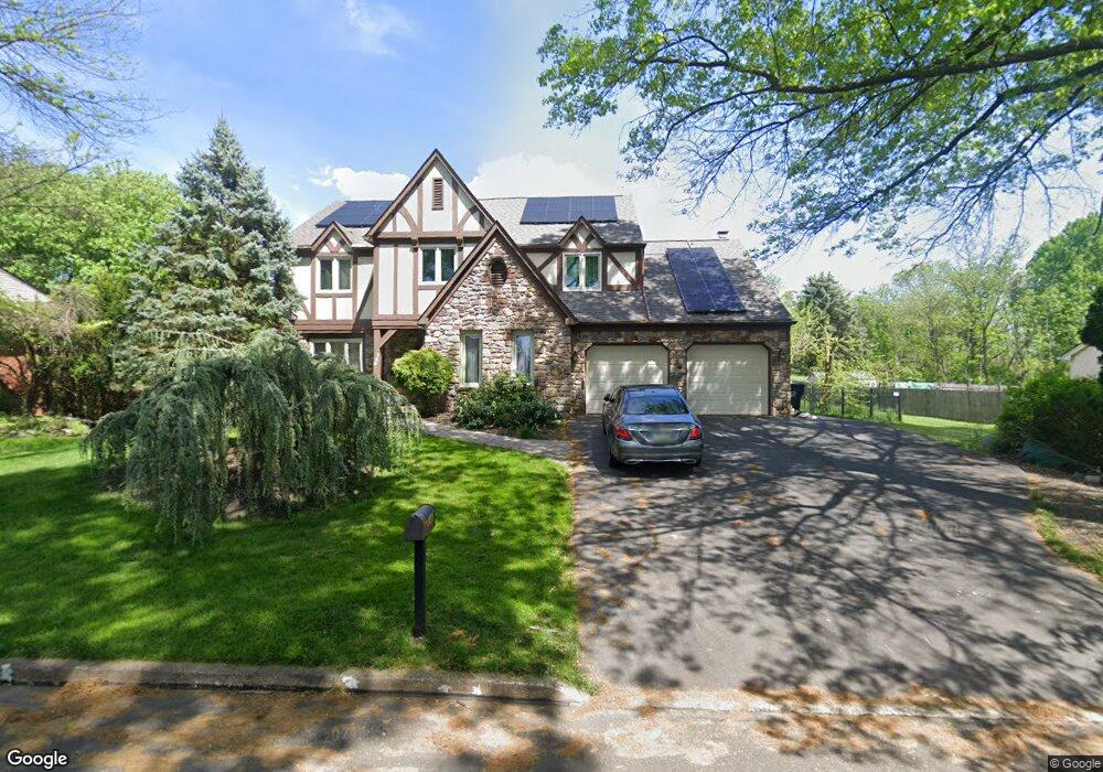
140 Forrest Dr Southampton, PA 18966
Estimated Value: $774,451 - $854,000
4
Beds
3
Baths
3,168
Sq Ft
$259/Sq Ft
Est. Value
About This Home
This home is located at 140 Forrest Dr, Southampton, PA 18966 and is currently estimated at $821,613, approximately $259 per square foot. 140 Forrest Dr is a home located in Bucks County with nearby schools including Hillcrest El School, Holland Middle School, and Council Rock High School - South.
Ownership History
Date
Name
Owned For
Owner Type
Purchase Details
Closed on
Sep 8, 2015
Sold by
Khusid Rudolf and Khusid Nataliya
Bought by
Rudolph & Nataliya Khusid Living Trust and Khusid Nataliya
Current Estimated Value
Purchase Details
Closed on
Sep 11, 1997
Sold by
Locurcio Ralph V and Locurcio Ingrid
Bought by
Khusid Rudolf and Khusid Natalia
Home Financials for this Owner
Home Financials are based on the most recent Mortgage that was taken out on this home.
Original Mortgage
$172,000
Outstanding Balance
$26,281
Interest Rate
7.31%
Estimated Equity
$795,332
Purchase Details
Closed on
Jul 10, 1984
Bought by
Locurcio Ralph and Locurcio Ingrid
Create a Home Valuation Report for This Property
The Home Valuation Report is an in-depth analysis detailing your home's value as well as a comparison with similar homes in the area
Home Values in the Area
Average Home Value in this Area
Purchase History
| Date | Buyer | Sale Price | Title Company |
|---|---|---|---|
| Rudolph & Nataliya Khusid Living Trust | -- | Attorney | |
| Khusid Rudolf | $215,000 | -- | |
| Locurcio Ralph | $144,100 | -- |
Source: Public Records
Mortgage History
| Date | Status | Borrower | Loan Amount |
|---|---|---|---|
| Open | Khusid Rudolf | $172,000 |
Source: Public Records
Tax History Compared to Growth
Tax History
| Year | Tax Paid | Tax Assessment Tax Assessment Total Assessment is a certain percentage of the fair market value that is determined by local assessors to be the total taxable value of land and additions on the property. | Land | Improvement |
|---|---|---|---|---|
| 2025 | $8,105 | $42,080 | $5,720 | $36,360 |
| 2024 | $8,105 | $42,080 | $5,720 | $36,360 |
| 2023 | $7,639 | $42,080 | $5,720 | $36,360 |
| 2022 | $7,569 | $42,080 | $5,720 | $36,360 |
| 2021 | $7,329 | $42,080 | $5,720 | $36,360 |
| 2020 | $7,165 | $42,080 | $5,720 | $36,360 |
| 2019 | $6,858 | $42,080 | $5,720 | $36,360 |
| 2018 | $6,736 | $42,080 | $5,720 | $36,360 |
| 2017 | $6,476 | $42,080 | $5,720 | $36,360 |
| 2016 | $6,476 | $42,080 | $5,720 | $36,360 |
| 2015 | -- | $42,080 | $5,720 | $36,360 |
| 2014 | -- | $42,080 | $5,720 | $36,360 |
Source: Public Records
Map
Nearby Homes
- 41 Grant Dr
- 6 Rolling Hills Dr
- 15 Penn Cir
- 100 E Holland Rd
- 27 Rocking Horse Way
- 21019 Bennett Place Unit 7
- 24 Standing Tree Cir
- 178 Buckshire Dr
- 270 Rocksville Rd
- 302 Independence Dr
- 52 Dalton Way
- 131 Rocksville Rd
- 6 Springwood Place
- 151 Knox Ct
- 327 Hale Dr Unit 801A
- 6 Windy Knoll Dr
- 139 Heather Valley Rd
- 29 Langhorne Ave
- 147 Watergate Dr
- 15 Dover Place
- 146 Forrest Dr
- 136 Forrest Dr
- 150 Forrest Dr
- 132 Forrest Dr
- 149 Forrest Dr
- 271 Woodlake Dr
- 153 Forrest Dr
- 154 Forrest Dr
- 128 Forrest Dr
- 155 Forrest Dr
- 272 Woodlake Dr
- 267 Woodlake Dr
- 127 Forrest Dr
- 122 Forrest Dr
- 158 Forrest Dr
- 35 Crestview Dr
- 161 Forrest Dr
- 263 Woodlake Dr
- 162 Evergreen Ct
- 164 Evergreen Ct