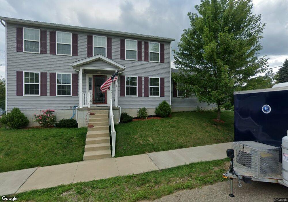
1401 Auld St Alliance, OH 44601
Estimated Value: $128,000 - $182,000
3
Beds
3
Baths
1,872
Sq Ft
$81/Sq Ft
Est. Value
About This Home
This home is located at 1401 Auld St, Alliance, OH 44601 and is currently estimated at $152,421, approximately $81 per square foot. 1401 Auld St is a home located in Stark County with nearby schools including Alliance Elementary School at Rockhill, Alliance Intermediate School at Northside, and Alliance Middle School.
Ownership History
Date
Name
Owned For
Owner Type
Purchase Details
Closed on
Apr 29, 2005
Sold by
Nicholson Vennie Lee
Bought by
Johnson Raymont Y and Johnson Brenda K
Current Estimated Value
Home Financials for this Owner
Home Financials are based on the most recent Mortgage that was taken out on this home.
Original Mortgage
$10,000
Interest Rate
7.75%
Mortgage Type
Credit Line Revolving
Purchase Details
Closed on
Apr 20, 2005
Sold by
Estate Of Oless Nicholson
Bought by
Nicholson Vennie Lee
Home Financials for this Owner
Home Financials are based on the most recent Mortgage that was taken out on this home.
Original Mortgage
$10,000
Interest Rate
7.75%
Mortgage Type
Credit Line Revolving
Create a Home Valuation Report for This Property
The Home Valuation Report is an in-depth analysis detailing your home's value as well as a comparison with similar homes in the area
Home Values in the Area
Average Home Value in this Area
Purchase History
| Date | Buyer | Sale Price | Title Company |
|---|---|---|---|
| Johnson Raymont Y | $12,500 | -- | |
| Nicholson Vennie Lee | -- | -- |
Source: Public Records
Mortgage History
| Date | Status | Borrower | Loan Amount |
|---|---|---|---|
| Previous Owner | Johnson Raymont Y | $10,000 |
Source: Public Records
Tax History
| Year | Tax Paid | Tax Assessment Tax Assessment Total Assessment is a certain percentage of the fair market value that is determined by local assessors to be the total taxable value of land and additions on the property. | Land | Improvement |
|---|---|---|---|---|
| 2025 | -- | $50,300 | $3,360 | $46,940 |
| 2024 | -- | $50,300 | $3,360 | $46,940 |
| 2023 | $1,850 | $46,030 | $3,430 | $42,600 |
| 2022 | $1,862 | $46,030 | $3,430 | $42,600 |
| 2021 | $1,864 | $46,030 | $3,430 | $42,600 |
| 2020 | $1,762 | $40,640 | $2,980 | $37,660 |
| 2019 | $1,780 | $40,640 | $2,980 | $37,660 |
| 2018 | $1,788 | $40,640 | $2,980 | $37,660 |
| 2017 | $1,641 | $36,620 | $2,490 | $34,130 |
| 2016 | $1,453 | $32,170 | $2,490 | $29,680 |
| 2015 | $1,423 | $31,230 | $2,490 | $28,740 |
| 2014 | $691 | $9,040 | $2,280 | $6,760 |
| 2013 | $210 | $9,040 | $2,280 | $6,760 |
Source: Public Records
Map
Nearby Homes
- 1522 Wade Ave
- 935 S Morgan Ave
- 834 Devine St
- 955 E Summit St
- 1350 S Freedom Ave
- 442 S Liberty Ave
- 452 E Summit St
- 390 E College St
- 231 Rosenberry St
- 226 Milner St
- 726 S Arch Ave
- 234 Rosenberry St
- 233 Shadyside Ct
- 167 11th St
- 225 Shadyside Ct
- V/L S Freedom Ave
- 134 11th St
- 46 Rosenberry St
- 847 E Patterson St
- 807 S Union Ave
- 1110 Willow Ave
- 1415 Auld St
- 1132 Willow Ave
- 1329 Auld St
- 1125 Willow Ave
- 1148 Willow Ave
- 1131 Willow Ave
- 1133 S Mahoning Ave
- 1315 Auld St
- 1150 Willow Ave
- 1131 S Mahoning Ave
- 1124 Meadow Ave
- 1132 Meadow Ave
- 1140 Meadow Ave
- 1406 South St
- 1416 South St
- 1185 S Mahoning Ave
- 1340 South St
- 1148 Meadow Ave
- 1130 S Mahoning Ave
Your Personal Tour Guide
Ask me questions while you tour the home.