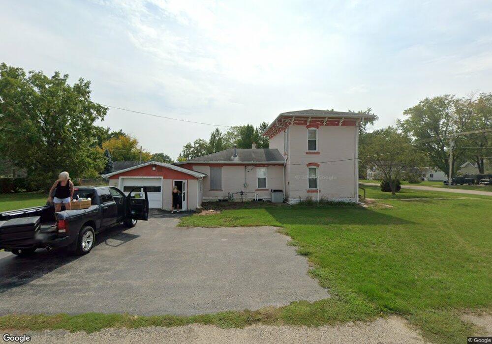
1402 W 3rd Ave Brodhead, WI 53520
Estimated Value: $199,000 - $229,000
3
Beds
1
Bath
1,384
Sq Ft
$152/Sq Ft
Est. Value
About This Home
This home is located at 1402 W 3rd Ave, Brodhead, WI 53520 and is currently estimated at $210,318, approximately $151 per square foot. 1402 W 3rd Ave is a home located in Green County with nearby schools including Ronald R. Albrecht Elementary School, Brodhead Middle School, and Brodhead High School.
Ownership History
Date
Name
Owned For
Owner Type
Purchase Details
Closed on
Sep 30, 2019
Sold by
Colstad Susan A
Bought by
Jamerz Enterprises Llc
Current Estimated Value
Home Financials for this Owner
Home Financials are based on the most recent Mortgage that was taken out on this home.
Original Mortgage
$54,800
Outstanding Balance
$47,578
Interest Rate
3.6%
Mortgage Type
Commercial
Estimated Equity
$162,740
Purchase Details
Closed on
Nov 6, 2017
Sold by
Abrahamson Susan and Hanawait Sally
Bought by
Colstad Susan A
Create a Home Valuation Report for This Property
The Home Valuation Report is an in-depth analysis detailing your home's value as well as a comparison with similar homes in the area
Home Values in the Area
Average Home Value in this Area
Purchase History
| Date | Buyer | Sale Price | Title Company |
|---|---|---|---|
| Jamerz Enterprises Llc | $68,500 | None Available | |
| Colstad Susan A | -- | None Available |
Source: Public Records
Mortgage History
| Date | Status | Borrower | Loan Amount |
|---|---|---|---|
| Open | Jamerz Enterprises Llc | $54,800 |
Source: Public Records
Tax History
| Year | Tax Paid | Tax Assessment Tax Assessment Total Assessment is a certain percentage of the fair market value that is determined by local assessors to be the total taxable value of land and additions on the property. | Land | Improvement |
|---|---|---|---|---|
| 2025 | $3,121 | $152,000 | $24,600 | $127,400 |
| 2024 | $2,926 | $152,000 | $24,600 | $127,400 |
| 2023 | $2,811 | $152,000 | $24,600 | $127,400 |
| 2022 | $2,674 | $136,500 | $18,200 | $118,300 |
| 2021 | $2,202 | $84,900 | $15,700 | $69,200 |
| 2020 | $2,167 | $84,900 | $15,700 | $69,200 |
| 2019 | $1,964 | $84,900 | $15,700 | $69,200 |
| 2018 | $1,882 | $84,900 | $15,700 | $69,200 |
| 2017 | $1,940 | $84,900 | $15,700 | $69,200 |
| 2016 | $1,931 | $84,900 | $15,700 | $69,200 |
| 2014 | $2,040 | $84,900 | $15,700 | $69,200 |
Source: Public Records
Map
Nearby Homes
- 1206 13th St
- 1202 1st Center Ave
- 1104 11th St
- 1504 W 7th Ave
- Lots 5 & 7 15th St E 7th Ave
- 701 E 2nd Ave
- 605 E 4th Ave
- 701 E 5th Ave
- 6 Acres 25th St
- Parcel 2355 1000
- Parcel 2355 2000
- Parcels 2355 1000 and 2355 2000
- N2741 & N2721 Highway 11
- 207 Cedar Ave
- 401 E 6th Ave
- 501 4th St
- 198 Juniper Ave
- 303 E 7th Ave
- N502 1st Center Ave
- N2594 Oak Ridge Rd
Your Personal Tour Guide
Ask me questions while you tour the home.