Estimated Value: $829,000 - $904,000
3
Beds
2
Baths
1,125
Sq Ft
$770/Sq Ft
Est. Value
About This Home
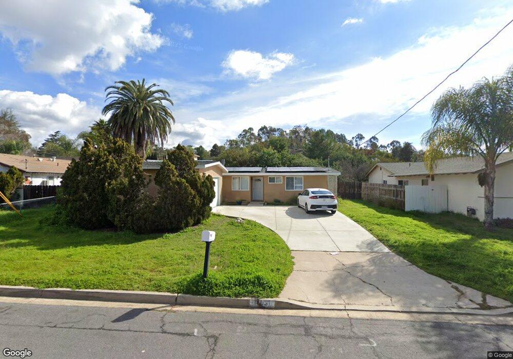
This home is located at 14037 Powers Rd, Poway, CA 92064 and is currently estimated at $866,408, approximately $770 per square foot. 14037 Powers Rd is a home located in San Diego County with nearby schools including Pomerado Elementary, Meadowbrook Middle, and Poway High.
Ownership History
Date
Name
Owned For
Owner Type
Purchase Details
Closed on
Mar 23, 2011
Sold by
Tong Pansy S
Bought by
Ritchie Philip Daniel and Jourdonais Kristen Michelle
Current Estimated Value
Home Financials for this Owner
Home Financials are based on the most recent Mortgage that was taken out on this home.
Original Mortgage
$342,202
Outstanding Balance
$236,342
Interest Rate
4.9%
Mortgage Type
VA
Estimated Equity
$630,066
Purchase Details
Closed on
Mar 26, 2002
Sold by
Tong Peter S and Tong Peter Sing Pui
Bought by
Tong Pansy S
Create a Home Valuation Report for This Property
The Home Valuation Report is an in-depth analysis detailing your home's value as well as a comparison with similar homes in the area
Home Values in the Area
Average Home Value in this Area
Purchase History
| Date | Buyer | Sale Price | Title Company |
|---|---|---|---|
| Ritchie Philip Daniel | $335,000 | Stewart Title Of Ca Inc | |
| Tong Pansy S | $101,500 | Commonwealth Land Title Co |
Source: Public Records
Mortgage History
| Date | Status | Borrower | Loan Amount |
|---|---|---|---|
| Open | Ritchie Philip Daniel | $342,202 |
Source: Public Records
Tax History
| Year | Tax Paid | Tax Assessment Tax Assessment Total Assessment is a certain percentage of the fair market value that is determined by local assessors to be the total taxable value of land and additions on the property. | Land | Improvement |
|---|---|---|---|---|
| 2025 | $4,738 | $429,181 | $352,316 | $76,865 |
| 2024 | $4,738 | $420,766 | $345,408 | $75,358 |
| 2023 | $4,637 | $412,517 | $338,636 | $73,881 |
| 2022 | $4,559 | $404,430 | $331,997 | $72,433 |
| 2021 | $4,500 | $396,501 | $325,488 | $71,013 |
| 2020 | $4,439 | $392,436 | $322,151 | $70,285 |
| 2019 | $4,324 | $384,742 | $315,835 | $68,907 |
| 2018 | $4,203 | $377,199 | $309,643 | $67,556 |
| 2017 | $4,091 | $369,804 | $303,572 | $66,232 |
| 2016 | $4,006 | $362,554 | $297,620 | $64,934 |
| 2015 | $3,947 | $357,109 | $293,150 | $63,959 |
| 2014 | $3,854 | $350,115 | $287,408 | $62,707 |
Source: Public Records
Map
Nearby Homes
- 12311 Witt Rd
- 13824 Powers Rd
- 14109 Arbolitos Dr
- 12834 Rockwell Ct
- 13641 Carriage Rd
- 14138 Brent Wilsey Place Unit 3
- 14110 Brent Wilsey Place Unit 1
- 13442 Mountainside Dr
- 12885 Rockwell Ct
- 11908 Tivoli Park Row Unit 7
- 12614 Orohaven Ln
- 12739 Papago Dr
- 14613 Plumwood St
- 12939 Cree Ct
- 13673 Shoal Summit Dr
- 12450 Robison Blvd
- 13847 Carmel Ridge Rd Unit 1
- 13254 Powers Ct
- 13957 Carmel Ridge Rd
- 12851 Papago Dr
- 14031 Powers Rd
- 14043 Powers Rd
- 14038 Frame Rd
- 14025 Powers Rd
- 14032 Frame Rd
- 14044 Frame Rd
- 14049 Powers Rd
- 14036 Powers Rd
- 14042 Powers Rd
- 14030 Powers Rd
- 14026 Frame Rd
- 14050 Frame Rd
- 14019 Powers Rd
- 14024 Powers Rd
- 14048 Powers Rd
- 14020 Frame Rd
- 14018 Powers Rd
- 14013 Powers Rd
- 14105 Powers Rd
- 14039 Frame Rd
Your Personal Tour Guide
Ask me questions while you tour the home.