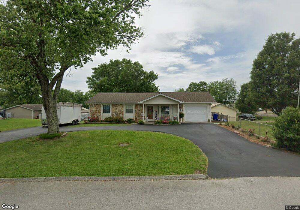
1405 Debi Cir Morristown, TN 37813
Estimated Value: $159,795 - $233,000
--
Bed
2
Baths
984
Sq Ft
$203/Sq Ft
Est. Value
About This Home
This home is located at 1405 Debi Cir, Morristown, TN 37813 and is currently estimated at $199,449, approximately $202 per square foot. 1405 Debi Cir is a home located in Hamblen County with nearby schools including Hillcrest Elementary School, Meadowview Middle School, and Morristown East High School.
Ownership History
Date
Name
Owned For
Owner Type
Purchase Details
Closed on
Oct 19, 1995
Sold by
Snyder Louise T
Bought by
Murphy Joann
Current Estimated Value
Purchase Details
Closed on
Jun 22, 1990
Bought by
Snyder Louise T
Purchase Details
Closed on
Nov 5, 1985
Bought by
King Lester and King Jennifer
Purchase Details
Closed on
Feb 24, 1979
Bought by
Rader Mark Gregory
Create a Home Valuation Report for This Property
The Home Valuation Report is an in-depth analysis detailing your home's value as well as a comparison with similar homes in the area
Home Values in the Area
Average Home Value in this Area
Purchase History
| Date | Buyer | Sale Price | Title Company |
|---|---|---|---|
| Murphy Joann | $44,000 | -- | |
| Snyder Louise T | $39,200 | -- | |
| King Lester | $31,500 | -- | |
| Rader Mark Gregory | $20,000 | -- |
Source: Public Records
Tax History Compared to Growth
Tax History
| Year | Tax Paid | Tax Assessment Tax Assessment Total Assessment is a certain percentage of the fair market value that is determined by local assessors to be the total taxable value of land and additions on the property. | Land | Improvement |
|---|---|---|---|---|
| 2024 | $378 | $21,500 | $4,100 | $17,400 |
| 2023 | $378 | $21,500 | $0 | $0 |
| 2022 | $679 | $21,500 | $4,100 | $17,400 |
| 2021 | $679 | $21,500 | $4,100 | $17,400 |
| 2020 | $678 | $21,500 | $4,100 | $17,400 |
| 2019 | $677 | $19,900 | $3,650 | $16,250 |
| 2018 | $627 | $19,900 | $3,650 | $16,250 |
| 2017 | $597 | $19,275 | $3,650 | $15,625 |
| 2016 | $570 | $19,275 | $3,650 | $15,625 |
| 2015 | $531 | $19,275 | $3,650 | $15,625 |
| 2014 | -- | $19,275 | $3,650 | $15,625 |
| 2013 | -- | $20,350 | $0 | $0 |
Source: Public Records
Map
Nearby Homes
- 1205 Ledford Ave
- 1200 Liberty Hall Dr
- 000 Bacon Ln
- 808 Gaston St
- 0 Russell Cir
- 0 Joe Hall Rd Unit 703714
- 819 Choctaw St
- 816 Choctaw St
- 915 Forgey Ave
- 1670 Oak St
- 525 S Liberty Hill Rd
- Lot 101 Geneva Ln
- Lot 99 Geneva Ln
- 98 Geneva Ln
- Lot 100 Geneva Ln
- 712 Williams St
- 423 Hayter Dr
- 0 S Liberty Hill Rd Unit 703697
- 831 Cave St
- 460 Ash St
- 1220 Joe Hall Rd
- 1401 Debi Cir
- 1216 Joe Hall Rd
- 1223 Ledford Ave
- 1408 Debi Cir
- 1404 Debi Cir
- 1212 Joe Hall Rd
- 1219 Ledford Ave
- 1400 Debi Cir
- 1208 Joe Hall Rd
- 1189 Joe Hall Rd
- 1215 Ledford Ave
- 1212 Ledford Ave
- 1344 Debi Cir
- 1041 Allegiance Way
- 1204 Joe Hall Rd
- 1209 Ledford Ave
- 1101 Bacon Ln
- 1340 Debi Cir
- 1043 Allegiance Way