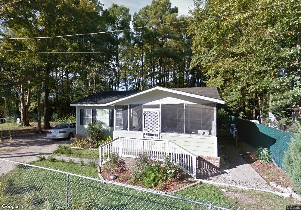
1406 Shavis Ct Myrtle Beach, SC 29577
Downtown Myrtle Beach NeighborhoodEstimated Value: $150,167 - $161,000
3
Beds
1
Bath
816
Sq Ft
$193/Sq Ft
Est. Value
About This Home
This home is located at 1406 Shavis Ct, Myrtle Beach, SC 29577 and is currently estimated at $157,292, approximately $192 per square foot. 1406 Shavis Ct is a home located in Horry County with nearby schools including Myrtle Beach Child Development Center, Myrtle Beach Primary School, and Myrtle Beach Elementary School.
Ownership History
Date
Name
Owned For
Owner Type
Purchase Details
Closed on
Dec 7, 2017
Sold by
Dap Of Mb Llc
Bought by
Hkr Group Llc
Current Estimated Value
Purchase Details
Closed on
Nov 9, 2012
Sold by
Dap Of Mb Llc
Bought by
Dingle John
Purchase Details
Closed on
Sep 14, 2012
Sold by
Anderson Brothers Bank
Bought by
Dap Of Mb Llc
Purchase Details
Closed on
Aug 31, 2012
Sold by
Master In Equity Horry County
Bought by
Anderson Brothers Bank
Purchase Details
Closed on
Oct 6, 2008
Sold by
Graves Ronnie L
Bought by
Grant Joseph K
Purchase Details
Closed on
Jan 18, 2007
Sold by
Mccallum Clara
Bought by
Graves Ronnie L
Create a Home Valuation Report for This Property
The Home Valuation Report is an in-depth analysis detailing your home's value as well as a comparison with similar homes in the area
Home Values in the Area
Average Home Value in this Area
Purchase History
| Date | Buyer | Sale Price | Title Company |
|---|---|---|---|
| Hkr Group Llc | $30,000 | -- | |
| Dingle John | $60,000 | -- | |
| Dap Of Mb Llc | $25,000 | -- | |
| Anderson Brothers Bank | $59,000 | -- | |
| Grant Joseph K | -- | -- | |
| Graves Ronnie L | -- | None Available |
Source: Public Records
Tax History Compared to Growth
Tax History
| Year | Tax Paid | Tax Assessment Tax Assessment Total Assessment is a certain percentage of the fair market value that is determined by local assessors to be the total taxable value of land and additions on the property. | Land | Improvement |
|---|---|---|---|---|
| 2024 | $1,418 | $7,147 | $1,750 | $5,397 |
| 2023 | $1,418 | $4,841 | $335 | $4,506 |
| 2021 | $1,308 | $4,841 | $335 | $4,506 |
| 2020 | $1,247 | $4,841 | $335 | $4,506 |
| 2019 | $1,015 | $4,841 | $335 | $4,506 |
| 2018 | $912 | $5,632 | $224 | $5,408 |
| 2017 | $174 | $3,425 | $335 | $3,090 |
| 2016 | -- | $2,284 | $224 | $2,060 |
| 2015 | $172 | $2,284 | $224 | $2,060 |
| 2014 | $155 | $2,284 | $224 | $2,060 |
Source: Public Records
Map
Nearby Homes
- TBD Acline Ave
- 913 White St
- 1009 3rd Ave N
- (1.5 Acres) 10th Ave N
- 1005 3rd Ave N Unit Multi-family lot
- 850 Maxine Ct Unit 5B
- 904 3rd Ave N
- 1112 Ocala St
- 1102 Spivey Ave
- 1211 Washington St
- 1377 E Highway 501
- 1104 Dunbar St
- 603 Maple St
- 1101 Carver St
- 506 Maple St Unit 508 Maple St.
- 0000 Racepath St
- 503 7th Ave N
- 0 3rd Ave S
- 315 Chapman Place
- 1001 Graham Ave
- 1410 Shavis Ct Unit Canal Sec; Lt 8 Of L
- 1420 Shavis Ct
- 821 Canal St
- 825 Canal St
- 1401 Shavis Ct
- 815 Canal St
- 1618 Andrew Jack Mitchell Ln
- 1612 Andrew Jack Mitchell Ln
- 827 Canal St
- 1600 Andrew Jack Mitchell Ln
- 1314 Dennison Ave
- 1606 Andrew Jack Mitchell Ln
- 823 Canal St
- 828 Canal St
- 911 Canal St
- 900 Canal St
- 824 Canal St
- 851 Grey St
- 826 Canal St
- 831 Canal St