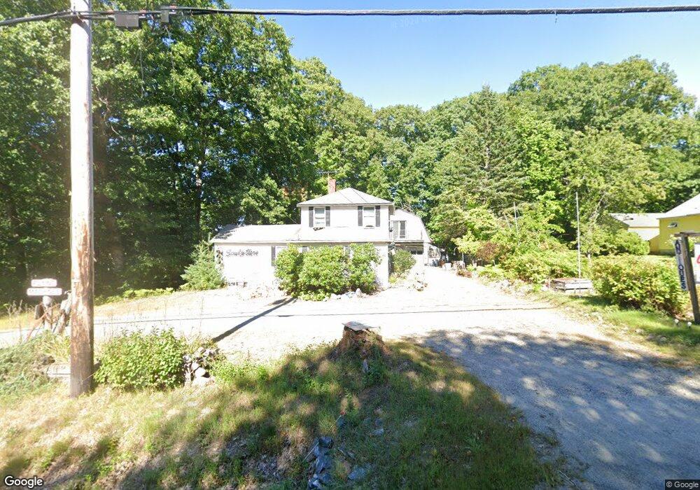
1407 State Highway 102 Bar Harbor, ME 04609
Estimated Value: $314,000 - $487,341
2
Beds
1
Bath
1,940
Sq Ft
$189/Sq Ft
Est. Value
About This Home
This home is located at 1407 State Highway 102, Bar Harbor, ME 04609 and is currently estimated at $366,585, approximately $188 per square foot. 1407 State Highway 102 is a home located in Hancock County with nearby schools including Conners-Emerson School and Mt. Desert Island High School.
Ownership History
Date
Name
Owned For
Owner Type
Purchase Details
Closed on
Apr 17, 2025
Sold by
Abdelnour Ernest P Est and Abdelnour
Bought by
Putnam Kenneth R and Putnam Angelia S
Current Estimated Value
Home Financials for this Owner
Home Financials are based on the most recent Mortgage that was taken out on this home.
Original Mortgage
$290,250
Outstanding Balance
$288,429
Interest Rate
6.63%
Mortgage Type
Purchase Money Mortgage
Estimated Equity
$78,156
Create a Home Valuation Report for This Property
The Home Valuation Report is an in-depth analysis detailing your home's value as well as a comparison with similar homes in the area
Home Values in the Area
Average Home Value in this Area
Purchase History
| Date | Buyer | Sale Price | Title Company |
|---|---|---|---|
| Putnam Kenneth R | $322,500 | None Available | |
| Putnam Kenneth R | $322,500 | None Available | |
| Putnam Kenneth R | $322,500 | None Available |
Source: Public Records
Mortgage History
| Date | Status | Borrower | Loan Amount |
|---|---|---|---|
| Open | Putnam Kenneth R | $290,250 | |
| Closed | Putnam Kenneth R | $290,250 |
Source: Public Records
Tax History Compared to Growth
Tax History
| Year | Tax Paid | Tax Assessment Tax Assessment Total Assessment is a certain percentage of the fair market value that is determined by local assessors to be the total taxable value of land and additions on the property. | Land | Improvement |
|---|---|---|---|---|
| 2024 | $3,713 | $369,800 | $184,900 | $184,900 |
| 2023 | $3,210 | $369,800 | $184,900 | $184,900 |
| 2022 | $2,915 | $312,800 | $156,400 | $156,400 |
| 2021 | $2,770 | $284,400 | $142,200 | $142,200 |
| 2020 | $2,722 | $228,700 | $120,100 | $108,600 |
| 2019 | $2,683 | $226,400 | $118,900 | $107,500 |
| 2018 | $2,617 | $226,400 | $118,900 | $107,500 |
| 2017 | $2,481 | $226,400 | $118,900 | $107,500 |
| 2016 | $2,429 | $226,400 | $118,900 | $107,500 |
| 2015 | $2,398 | $226,400 | $118,900 | $107,500 |
| 2014 | $2,314 | $226,400 | $118,900 | $107,500 |
| 2012 | $2,228 | $226,400 | $118,900 | $107,500 |
Source: Public Records
Map
Nearby Homes
- 38 Indian Point Rd
- Lot 79-01 Knox Rd
- 27 M J Ln
- 14 Island Woods Rd
- Lot 38 Arrowhead Rd
- 16 Blodgett Ln
- 16 Blodgett Dr
- 34 Frenchmans Hill E
- 1427 State Highway 3
- 39 Kitteridge Brook Rd
- Lot 3 Belle Grande Dr
- Lot 4 Belle Grande Dr
- Lot #9-4 Oak Hill Rd
- 0 Country Way
- Lot 5 Bluff Rd
- Lot 001 Crooked Rd
- 28 Winding Brook Rd
- 37 Hanna Dr
- 71 Bay View Dr
- 001-108 Oak Point Rd
- 1403 State Highway 102
- 1397 State Highway 102
- 1408 State Highway 102
- 1414 State Highway 102
- 1402 State Highway 102
- 1402 State Highway 102
- 1420 State Highway 102
- 1402 State Highway 102
- 0 W Eden Ave
- Lot 1 Indian Point Rd
- 3 Indian Point Rd
- 5 Indian Point Rd
- 18 Eden Way
- 16 Eden Way Unit 16
- 12 Eden Way Unit 12
- Lot 2 Indian Point Rd
- 1388 Maine 102
- 4 Off Indian Pt Rd-Aunt Mollys Beach
- 1388 State Highway 102
- 0 Eden Way