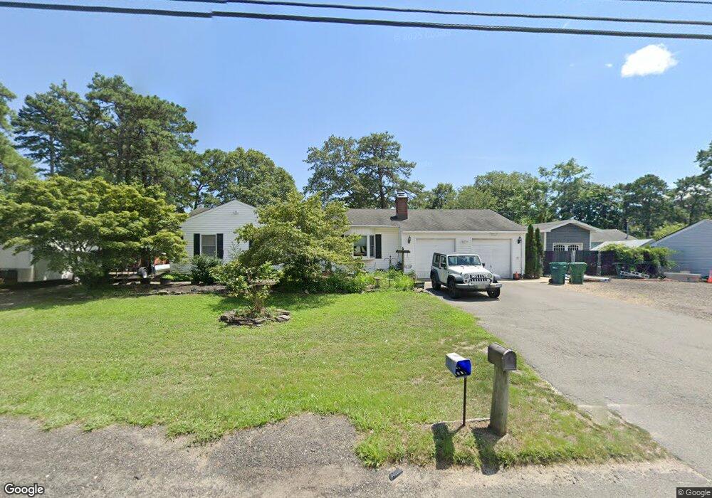
1408 Commonwealth Blvd Toms River, NJ 08757
Manchester Township NeighborhoodEstimated Value: $497,769 - $592,000
3
Beds
2
Baths
2,782
Sq Ft
$198/Sq Ft
Est. Value
About This Home
This home is located at 1408 Commonwealth Blvd, Toms River, NJ 08757 and is currently estimated at $550,442, approximately $197 per square foot. 1408 Commonwealth Blvd is a home located in Ocean County with nearby schools including Manchester Township High School and Ocean County Christian Academy.
Ownership History
Date
Name
Owned For
Owner Type
Purchase Details
Closed on
Feb 16, 2005
Sold by
Peters Timothy
Bought by
Peters Timothy
Current Estimated Value
Purchase Details
Closed on
Aug 31, 2004
Sold by
Wilmot Cheryl L and Peters Cheryl L
Bought by
Peters Timothy
Purchase Details
Closed on
Jul 5, 1994
Sold by
Huttenloc Terry
Bought by
Peters Timothy and Peters Cheryl
Home Financials for this Owner
Home Financials are based on the most recent Mortgage that was taken out on this home.
Original Mortgage
$57,000
Interest Rate
8.19%
Create a Home Valuation Report for This Property
The Home Valuation Report is an in-depth analysis detailing your home's value as well as a comparison with similar homes in the area
Home Values in the Area
Average Home Value in this Area
Purchase History
| Date | Buyer | Sale Price | Title Company |
|---|---|---|---|
| Peters Timothy | -- | -- | |
| Peters Timothy | $125,000 | None Available | |
| Peters Timothy | $63,000 | -- |
Source: Public Records
Mortgage History
| Date | Status | Borrower | Loan Amount |
|---|---|---|---|
| Previous Owner | Peters Timothy | $57,000 |
Source: Public Records
Tax History Compared to Growth
Tax History
| Year | Tax Paid | Tax Assessment Tax Assessment Total Assessment is a certain percentage of the fair market value that is determined by local assessors to be the total taxable value of land and additions on the property. | Land | Improvement |
|---|---|---|---|---|
| 2025 | $7,053 | $533,600 | $308,800 | $224,800 |
| 2024 | $6,694 | $287,300 | $95,000 | $192,300 |
| 2023 | $6,364 | $287,300 | $95,000 | $192,300 |
| 2022 | $6,364 | $287,300 | $95,000 | $192,300 |
| 2021 | $6,226 | $287,300 | $95,000 | $192,300 |
| 2020 | $6,062 | $287,300 | $95,000 | $192,300 |
| 2019 | $6,266 | $244,300 | $95,000 | $149,300 |
| 2018 | $6,242 | $244,300 | $95,000 | $149,300 |
| 2017 | $6,266 | $244,300 | $95,000 | $149,300 |
| 2016 | $6,191 | $244,300 | $95,000 | $149,300 |
| 2015 | $6,076 | $241,600 | $95,000 | $146,600 |
| 2014 | $5,885 | $241,600 | $95,000 | $146,600 |
Source: Public Records
Map
Nearby Homes
- 1325 12th Ave
- 1200 Pemberton St
- 1309 Ninth Ave
- 1400 9th Ave
- 1212 Pemberton St
- 1305 8th Ave
- 1536 11th Ave
- 1408 Lawrence Ave
- 1541 Commonwealth Blvd
- 1516 9th Ave
- 1440 Lawrence Ave
- 1517 7th Ave
- 1300 Parkview Blvd
- 1112 Larchmont St
- 1200 Wellington Ave
- 1333 Monmouth Ave
- 1517 5th Ave
- 732 Ninth Ave
- 1517 Monmouth Ave
- 1625 7th Ave
- 1417 11th Ave
- 1400 Commonwealth Blvd
- 1401 11th Ave
- 1416 Commonwealth Blvd
- 1425 11th Ave
- 1417 Commonwealth Blvd
- 1401 Commonwealth Blvd
- 1113 Burnside St
- 1408 11th Ave
- 1424 Commonwealth Blvd
- 1416 11th Ave
- 1012 Burnside St
- 1341 11th Ave
- 1425 Commonwealth Blvd
- 1432 11th Ave
- 1113 Oakdale St
- 1162 Burnside St
- 1341 Commonwealth Blvd
- 1424 12th Ave
- 1013 Burnside St