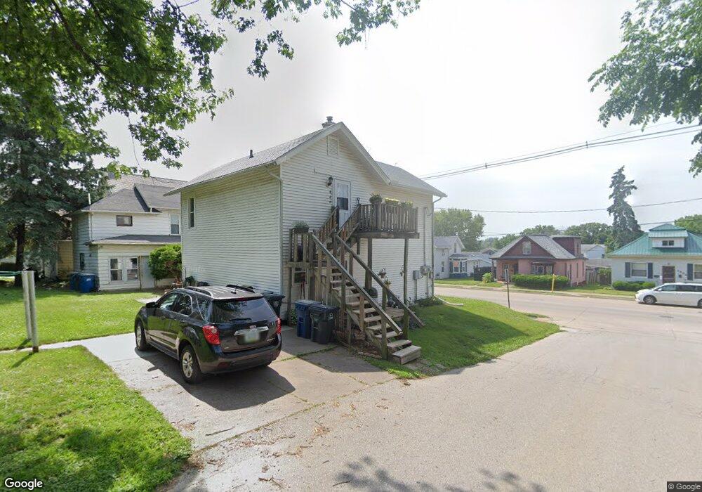
1409 Hershey Ave Muscatine, IA 52761
Estimated Value: $78,000 - $124,840
3
Beds
2
Baths
1,408
Sq Ft
$76/Sq Ft
Est. Value
About This Home
This home is located at 1409 Hershey Ave, Muscatine, IA 52761 and is currently estimated at $106,460, approximately $75 per square foot. 1409 Hershey Ave is a home located in Muscatine County with nearby schools including Franklin Elementary School, Susan Clark Junior High School, and Muscatine High School.
Ownership History
Date
Name
Owned For
Owner Type
Purchase Details
Closed on
Aug 30, 2019
Sold by
Wilson David A and Wilson Diana K
Bought by
Shipp Jerry E and Shipp Diane D
Current Estimated Value
Home Financials for this Owner
Home Financials are based on the most recent Mortgage that was taken out on this home.
Original Mortgage
$60,000
Outstanding Balance
$52,549
Interest Rate
3.7%
Mortgage Type
New Conventional
Estimated Equity
$53,911
Create a Home Valuation Report for This Property
The Home Valuation Report is an in-depth analysis detailing your home's value as well as a comparison with similar homes in the area
Home Values in the Area
Average Home Value in this Area
Purchase History
| Date | Buyer | Sale Price | Title Company |
|---|---|---|---|
| Shipp Jerry E | $80,000 | None Available |
Source: Public Records
Mortgage History
| Date | Status | Borrower | Loan Amount |
|---|---|---|---|
| Open | Shipp Jerry E | $60,000 |
Source: Public Records
Tax History Compared to Growth
Tax History
| Year | Tax Paid | Tax Assessment Tax Assessment Total Assessment is a certain percentage of the fair market value that is determined by local assessors to be the total taxable value of land and additions on the property. | Land | Improvement |
|---|---|---|---|---|
| 2025 | $1,826 | $101,790 | $13,600 | $88,190 |
| 2024 | $1,826 | $100,670 | $13,600 | $87,070 |
| 2023 | $1,686 | $96,831 | $13,568 | $83,263 |
| 2022 | $1,668 | $86,950 | $12,800 | $74,150 |
| 2021 | $1,668 | $81,750 | $12,800 | $68,950 |
| 2020 | $1,600 | $76,170 | $10,940 | $65,230 |
| 2019 | $1,776 | $80,410 | $0 | $0 |
| 2018 | $1,614 | $74,100 | $0 | $0 |
| 2017 | $1,590 | $70,380 | $0 | $0 |
| 2016 | $1,592 | $70,380 | $0 | $0 |
| 2015 | $1,592 | $64,010 | $0 | $0 |
| 2014 | $1,458 | $64,010 | $0 | $0 |
Source: Public Records
Map
Nearby Homes
- 0 Parcel 1302108019 (Busch St)
- 900 W 3rd St
- 1827 Hershey Ave
- LOTS 30-34 Evans St
- 1603 Lucas St
- 1903 Hershey Ave
- 609 Liberty St
- 111 Gilbert St
- 701 W Mississippi Dr
- 0 High Street Parcel
- 613 W 5th St
- 836 Newell Ave
- 410 Spruce St
- 511 W 7th St
- 1143 Logan St
- 315 W 3rd St
- 2108 Breese Ave
- 213 W 3rd St
- 2207 Lucas St
- 208 Fletcher Ave
- 1407 Hershey Ave
- 1405 Hershey Ave
- 1503 Hershey Ave
- 510 Main St
- 1505 Hershey Ave
- 1408 Hershey Ave
- 1403 Hershey Ave
- 508 Main St
- 512 Main St
- 1504 Hershey Ave
- 1412 Hershey Ave
- 1506 Hershey Ave
- 1507 Hershey Ave
- 1510 Hershey Ave
- 514 Main St
- 1509 Hershey Ave
- 1512 Hershey Ave
- 1404 Hershey Ave
- 507 Main St
- 1309 Hershey Ave