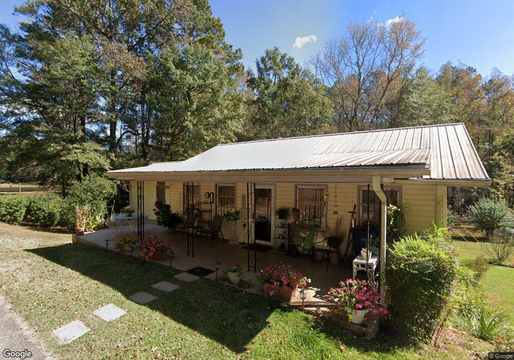
141 Avery Ln Lagrange, GA 30240
Estimated Value: $130,000 - $183,000
3
Beds
2
Baths
1,216
Sq Ft
$130/Sq Ft
Est. Value
About This Home
This home is located at 141 Avery Ln, Lagrange, GA 30240 and is currently estimated at $157,654, approximately $129 per square foot. 141 Avery Ln is a home located in Troup County with nearby schools including Berta Weathersbee Elementary School, Whitesville Road Elementary School, and Long Cane Elementary School.
Ownership History
Date
Name
Owned For
Owner Type
Purchase Details
Closed on
Jul 30, 2012
Sold by
Stanley Sarah Mcclure
Bought by
Freeman Thomas Edward
Current Estimated Value
Purchase Details
Closed on
Sep 29, 1995
Sold by
William R Stanley By Ex
Bought by
Stanley Sarah Margaret M
Purchase Details
Closed on
May 9, 1995
Sold by
William R Stanley
Bought by
William R Stanley By Ex
Purchase Details
Closed on
Oct 29, 1985
Bought by
William R Stanley
Create a Home Valuation Report for This Property
The Home Valuation Report is an in-depth analysis detailing your home's value as well as a comparison with similar homes in the area
Purchase History
| Date | Buyer | Sale Price | Title Company |
|---|---|---|---|
| Freeman Thomas Edward | -- | -- | |
| Stanley Sarah Margaret M | -- | -- | |
| William R Stanley By Ex | -- | -- | |
| William R Stanley | $23,500 | -- | |
| William R Stanley | $23,500 | -- |
Source: Public Records
Tax History
| Year | Tax Paid | Tax Assessment Tax Assessment Total Assessment is a certain percentage of the fair market value that is determined by local assessors to be the total taxable value of land and additions on the property. | Land | Improvement |
|---|---|---|---|---|
| 2025 | $1,241 | $51,880 | $10,560 | $41,320 |
| 2024 | $1,241 | $45,520 | $10,560 | $34,960 |
| 2023 | $1,244 | $2,375 | $0 | $2,375 |
| 2022 | $1,215 | $43,520 | $10,560 | $32,960 |
| 2021 | $875 | $29,000 | $3,960 | $25,040 |
| 2020 | $875 | $29,000 | $3,960 | $25,040 |
| 2019 | $743 | $24,640 | $5,200 | $19,440 |
| 2018 | $743 | $24,640 | $5,200 | $19,440 |
| 2017 | $743 | $24,640 | $5,200 | $19,440 |
| 2016 | $736 | $24,388 | $5,220 | $19,168 |
| 2015 | $731 | $24,185 | $5,220 | $18,965 |
| 2014 | $702 | $23,187 | $5,220 | $17,967 |
| 2013 | -- | $24,169 | $5,220 | $18,949 |
Source: Public Records
Map
Nearby Homes
- 3 Reed Dr
- 0 Unit 10514554
- 0 Bradfield Dr Unit 10568803
- 229 W Lakeview Dr
- 427 Fling Rd
- 509 Connie Dr
- 223 Pinehaven Dr
- 808 S Fling Rd
- 336 Whitaker Rd
- 167 S Kight Dr
- 114 Westgate Dr
- 117 Brookwood Dr
- 101 Crown St Unit LOT 5
- 102 Crown St Unit LOT 1
- The Rhodes Plan at Crown Street Cottages
- The Truitt Plan at Crown Street Cottages
- The Callaway Plan at Crown Street Cottages
- 205 Grady St
- 104 Spring Valley Dr
- 608 Wilburn Ave