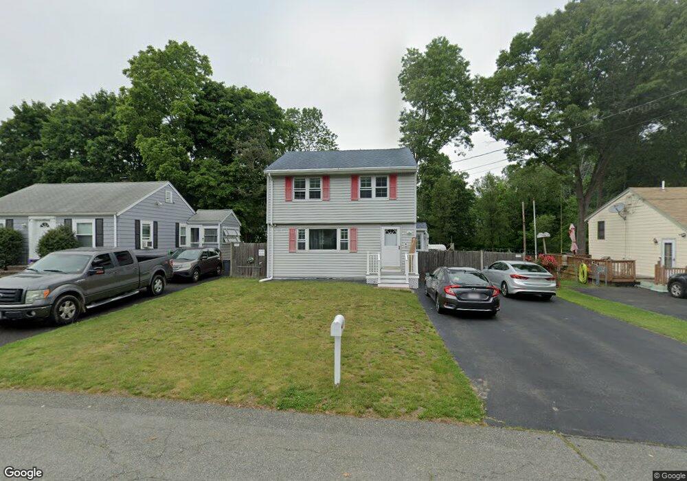
141 Hubbard Ave Brockton, MA 02301
Campello NeighborhoodEstimated Value: $466,000 - $515,000
3
Beds
2
Baths
1,316
Sq Ft
$372/Sq Ft
Est. Value
About This Home
This home is located at 141 Hubbard Ave, Brockton, MA 02301 and is currently estimated at $489,701, approximately $372 per square foot. 141 Hubbard Ave is a home located in Plymouth County with nearby schools including Gilmore Elementary School, Davis K-8 School, and John F. Kennedy Elementary School.
Ownership History
Date
Name
Owned For
Owner Type
Purchase Details
Closed on
Jul 13, 2000
Sold by
Dragone Priscilla M
Bought by
Dang Tuong V and Huynh Mai L
Current Estimated Value
Home Financials for this Owner
Home Financials are based on the most recent Mortgage that was taken out on this home.
Original Mortgage
$128,742
Interest Rate
8.5%
Mortgage Type
Purchase Money Mortgage
Create a Home Valuation Report for This Property
The Home Valuation Report is an in-depth analysis detailing your home's value as well as a comparison with similar homes in the area
Home Values in the Area
Average Home Value in this Area
Purchase History
| Date | Buyer | Sale Price | Title Company |
|---|---|---|---|
| Dang Tuong V | $139,900 | -- |
Source: Public Records
Mortgage History
| Date | Status | Borrower | Loan Amount |
|---|---|---|---|
| Open | Dang Tuong V | $100,000 | |
| Closed | Dang Tuong V | $127,717 | |
| Closed | Dang Tuong V | $128,164 | |
| Closed | Dang Tuong V | $128,742 |
Source: Public Records
Tax History Compared to Growth
Tax History
| Year | Tax Paid | Tax Assessment Tax Assessment Total Assessment is a certain percentage of the fair market value that is determined by local assessors to be the total taxable value of land and additions on the property. | Land | Improvement |
|---|---|---|---|---|
| 2025 | $4,918 | $406,100 | $153,600 | $252,500 |
| 2024 | $4,558 | $379,200 | $153,600 | $225,600 |
| 2023 | $4,843 | $373,100 | $103,600 | $269,500 |
| 2022 | $4,665 | $333,900 | $94,100 | $239,800 |
| 2021 | $4,407 | $303,900 | $85,300 | $218,600 |
| 2020 | $3,915 | $258,400 | $75,700 | $182,700 |
| 2019 | $4,084 | $262,800 | $71,400 | $191,400 |
| 2018 | $3,707 | $230,800 | $71,400 | $159,400 |
| 2017 | $3,360 | $208,700 | $71,400 | $137,300 |
| 2016 | $3,281 | $189,000 | $68,200 | $120,800 |
| 2015 | $3,153 | $173,700 | $68,200 | $105,500 |
| 2014 | $2,730 | $150,600 | $68,200 | $82,400 |
Source: Public Records
Map
Nearby Homes
- 358 Copeland St
- 15 Longworth Ave Unit 231
- 13 Finny's Way
- 35 Longworth Ave Unit 17
- 15 Fieldstone Dr
- 47 Southworth St
- 1 Fairway Dr
- 1435 Main St
- 57 Copeland St
- 21 Roosevelt Ave
- 15 Otto St
- 115 Market St
- 163 S Leyden St
- 16 Friendship Dr
- 223 Clinton St Unit 10
- 223 Clinton St Unit 3
- 223 Clinton St Unit 16
- 65 Tremont St
- 1036 Ash St
- 137 Channing Ave
- 147 Hubbard Ave
- 137 Hubbard Ave
- 151 Hubbard Ave
- 30 Langdon St
- 142 Hubbard Ave
- 148 Hubbard Ave
- 138 Hubbard Ave
- 184 Hubbard Ave
- 133 Hubbard Ave
- 330 Copeland St
- 350 Copeland St
- 328 Copeland St
- 89 Glendale Ave
- 87 Glendale Ave
- 130 Hubbard Ave
- 326 Copeland St
- 81 Glendale Ave
- 31 Langdon St
- 362 Copeland St
- 12 Oakside Ave