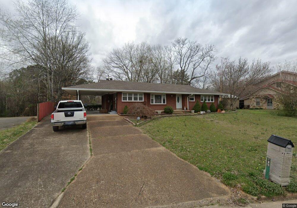
141 N Forrest Ave Camden, TN 38320
Estimated Value: $180,000 - $222,000
--
Bed
2
Baths
1,560
Sq Ft
$127/Sq Ft
Est. Value
About This Home
This home is located at 141 N Forrest Ave, Camden, TN 38320 and is currently estimated at $198,140, approximately $127 per square foot. 141 N Forrest Ave is a home located in Benton County with nearby schools including Camden Elementary School, Briarwood School, and Camden Junior High School.
Ownership History
Date
Name
Owned For
Owner Type
Purchase Details
Closed on
Nov 15, 2024
Sold by
Ross Rebecca Joan
Bought by
Ross Amanda S
Current Estimated Value
Purchase Details
Closed on
Aug 31, 2007
Sold by
Ross Larry
Bought by
Ross Rebecca J
Purchase Details
Closed on
Apr 2, 2002
Bought by
Ross Larry
Purchase Details
Closed on
May 28, 1991
Bought by
Stockard Finis and Stockard Sudie
Purchase Details
Closed on
Jul 5, 1984
Bought by
Holland James H and Holland Mildred
Create a Home Valuation Report for This Property
The Home Valuation Report is an in-depth analysis detailing your home's value as well as a comparison with similar homes in the area
Home Values in the Area
Average Home Value in this Area
Purchase History
| Date | Buyer | Sale Price | Title Company |
|---|---|---|---|
| Ross Amanda S | -- | None Listed On Document | |
| Ross Amanda S | -- | None Listed On Document | |
| Ross Rebecca J | -- | -- | |
| Ross Larry | $31,500 | -- | |
| Stockard Finis | $66,000 | -- | |
| Holland James H | -- | -- |
Source: Public Records
Tax History Compared to Growth
Tax History
| Year | Tax Paid | Tax Assessment Tax Assessment Total Assessment is a certain percentage of the fair market value that is determined by local assessors to be the total taxable value of land and additions on the property. | Land | Improvement |
|---|---|---|---|---|
| 2024 | $1,266 | $34,525 | $3,250 | $31,275 |
| 2023 | $1,266 | $34,525 | $3,250 | $31,275 |
| 2022 | $1,168 | $31,875 | $3,250 | $28,625 |
| 2021 | $1,168 | $31,875 | $3,250 | $28,625 |
| 2020 | $1,169 | $31,875 | $3,250 | $28,625 |
| 2019 | $1,014 | $25,650 | $3,250 | $22,400 |
| 2018 | $1,014 | $25,650 | $3,250 | $22,400 |
| 2017 | $1,014 | $25,650 | $3,250 | $22,400 |
| 2016 | $1,014 | $25,650 | $3,250 | $22,400 |
| 2015 | $1,023 | $25,650 | $3,250 | $22,400 |
| 2014 | $993 | $25,650 | $3,250 | $22,400 |
| 2013 | $993 | $25,195 | $0 | $0 |
Source: Public Records
Map
Nearby Homes
- 136 N Forrest Ave
- 121 Washington Ave
- 125 Washington Ave
- 116 N Church Ave
- 119 Maple Ave
- 116 Magnolia St
- 1 Maple Ave
- 154 Mcrae St
- 156 W Main St
- 121 Davidson St
- 0 Forrest Ave N
- 129 S Forrest Ave
- 111 Melton Ave
- 107 Melton Ave
- 215 Woodside St
- 1762 Washington Ave
- 197 Stigall St
- 144 Post Oak Ave
- 180 Post Oak Ave
- 000 Wyly St
- 143 N Forrest Ave
- 138 N Forrest Ave
- 112 W Lockhart St
- 135 N Forrest Ave
- 140 N Church Ave
- 114 W Lockhart St
- 133 N Forrest Ave
- 142 N Church Ave
- 138 N Church Ave
- 130 N Forrest Ave
- 144 N Church Ave
- 136 N Church Ave
- 134 N Church Ave
- 153 Forrest and Poplar
- 132 N Church Ave
- 105 Green St
- 131 N Forrest Ave
- 155 N Forrest Ave
- 133 Hall Ave
- 129 N Forrest Ave