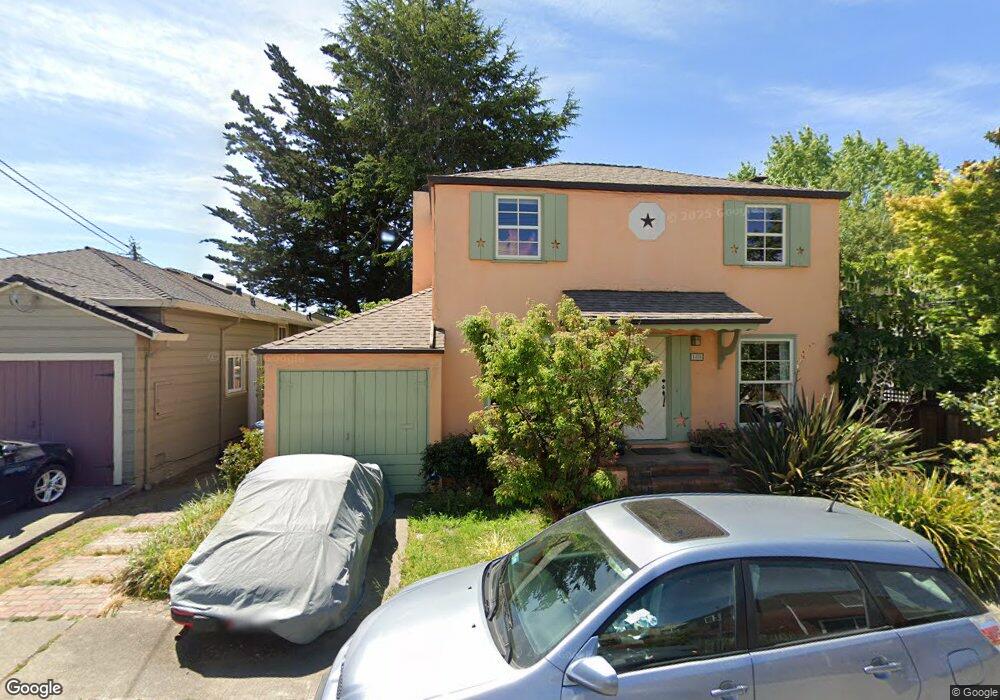
1410 Keoncrest Dr Berkeley, CA 94702
West Berkeley NeighborhoodEstimated Value: $1,110,000 - $1,531,000
2
Beds
1
Bath
1,040
Sq Ft
$1,227/Sq Ft
Est. Value
About This Home
This home is located at 1410 Keoncrest Dr, Berkeley, CA 94702 and is currently estimated at $1,275,799, approximately $1,226 per square foot. 1410 Keoncrest Dr is a home located in Alameda County with nearby schools including Ruth Acty Elementary, Berkeley Arts Magnet at Whittier School, and Thousand Oaks Elementary School.
Ownership History
Date
Name
Owned For
Owner Type
Purchase Details
Closed on
Aug 18, 2011
Sold by
Sexton Emily D
Bought by
Livin Sexton Emily D and Livin Emily D Sexton Revocable
Current Estimated Value
Purchase Details
Closed on
Jul 24, 2000
Sold by
Taniguchi Kinya and Taniguchi Jean N
Bought by
Sexton Emily D
Home Financials for this Owner
Home Financials are based on the most recent Mortgage that was taken out on this home.
Original Mortgage
$280,800
Outstanding Balance
$99,696
Interest Rate
8.12%
Estimated Equity
$1,176,103
Create a Home Valuation Report for This Property
The Home Valuation Report is an in-depth analysis detailing your home's value as well as a comparison with similar homes in the area
Home Values in the Area
Average Home Value in this Area
Purchase History
| Date | Buyer | Sale Price | Title Company |
|---|---|---|---|
| Livin Sexton Emily D | -- | None Available | |
| Sexton Emily D | $351,000 | Placer Title Company |
Source: Public Records
Mortgage History
| Date | Status | Borrower | Loan Amount |
|---|---|---|---|
| Open | Sexton Emily D | $280,800 | |
| Closed | Sexton Emily D | $35,100 |
Source: Public Records
Tax History
| Year | Tax Paid | Tax Assessment Tax Assessment Total Assessment is a certain percentage of the fair market value that is determined by local assessors to be the total taxable value of land and additions on the property. | Land | Improvement |
|---|---|---|---|---|
| 2025 | $7,107 | $428,079 | $127,964 | $307,115 |
| 2024 | $7,107 | $419,549 | $125,455 | $301,094 |
| 2023 | $6,952 | $418,187 | $122,996 | $295,191 |
| 2022 | $6,814 | $402,989 | $120,585 | $289,404 |
| 2021 | $6,819 | $394,952 | $118,221 | $283,731 |
| 2020 | $6,436 | $397,832 | $117,009 | $280,823 |
| 2019 | $6,160 | $390,033 | $114,715 | $275,318 |
| 2018 | $6,049 | $382,387 | $112,466 | $269,921 |
| 2017 | $5,822 | $374,891 | $110,262 | $264,629 |
| 2016 | $5,615 | $367,541 | $108,100 | $259,441 |
| 2015 | $5,538 | $362,022 | $106,477 | $255,545 |
| 2014 | $5,492 | $354,930 | $104,391 | $250,539 |
Source: Public Records
Map
Nearby Homes
- 1564 Sacramento St
- 1322 Virginia St
- 1436 Delaware St
- 1516 Belvedere Ave
- 1813 Sacramento St
- 1411 Hearst Ave Unit 2
- 1529 Ada St
- 1207 Francisco St
- 1207 Francisco St Unit 2
- 1728 Curtis St
- 1261 Hearst Ave
- 1400 Santa fe Ave
- 1128 Delaware St
- 1919 Curtis St
- 1808 Cedar St
- 1509 Francis St
- 1815 Vine St
- 1120 Curtis St
- 1230 Addison St
- 2118 California St
- 1539 Acton St
- 1420 Keoncrest Dr
- 1545 Acton St
- 1430 Keoncrest Dr
- 1549 Acton St
- 1415 Keoncrest Dr
- 1529 Acton St
- 1419 Cedar St
- 1440 Keoncrest Dr
- 1415 Cedar St
- 1429 Cedar St
- 1555 Acton St
- 1525 Acton St
- 1431 Catherine Dr
- 1439 Cedar St
- 1450 Keoncrest Dr
- 1544 Acton St
- 1538 Acton St
- 1548 Acton St
- 1521 Acton St
Your Personal Tour Guide
Ask me questions while you tour the home.