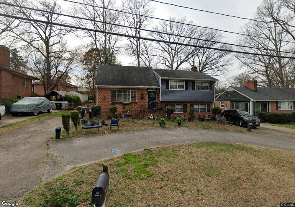
1412 Huntland Rd Richmond, VA 23225
Cedarhurst NeighborhoodEstimated Value: $333,830 - $389,000
4
Beds
3
Baths
1,785
Sq Ft
$207/Sq Ft
Est. Value
About This Home
This home is located at 1412 Huntland Rd, Richmond, VA 23225 and is currently estimated at $370,208, approximately $207 per square foot. 1412 Huntland Rd is a home located in Richmond City with nearby schools including Southampton Elementary School, Lucille M. Brown Middle, and Huguenot High School.
Ownership History
Date
Name
Owned For
Owner Type
Purchase Details
Closed on
Jun 29, 2001
Sold by
Brown Lowell S
Bought by
Barr Oscar W and Barr Pamela M
Current Estimated Value
Home Financials for this Owner
Home Financials are based on the most recent Mortgage that was taken out on this home.
Original Mortgage
$106,050
Outstanding Balance
$40,869
Interest Rate
7.14%
Mortgage Type
New Conventional
Estimated Equity
$329,339
Purchase Details
Closed on
Jan 21, 2000
Sold by
Wade Amigo R and Wade Ojeda R
Bought by
Brown Lowell S and Brown Sylvia K
Home Financials for this Owner
Home Financials are based on the most recent Mortgage that was taken out on this home.
Original Mortgage
$90,000
Interest Rate
7.84%
Mortgage Type
New Conventional
Create a Home Valuation Report for This Property
The Home Valuation Report is an in-depth analysis detailing your home's value as well as a comparison with similar homes in the area
Home Values in the Area
Average Home Value in this Area
Purchase History
| Date | Buyer | Sale Price | Title Company |
|---|---|---|---|
| Barr Oscar W | $104,000 | -- | |
| Brown Lowell S | $95,000 | -- |
Source: Public Records
Mortgage History
| Date | Status | Borrower | Loan Amount |
|---|---|---|---|
| Open | Barr Oscar W | $106,050 | |
| Previous Owner | Brown Lowell S | $90,000 |
Source: Public Records
Tax History Compared to Growth
Tax History
| Year | Tax Paid | Tax Assessment Tax Assessment Total Assessment is a certain percentage of the fair market value that is determined by local assessors to be the total taxable value of land and additions on the property. | Land | Improvement |
|---|---|---|---|---|
| 2025 | $3,300 | $275,000 | $63,000 | $212,000 |
| 2024 | $3,144 | $262,000 | $50,000 | $212,000 |
| 2023 | $2,988 | $249,000 | $50,000 | $199,000 |
| 2022 | $2,472 | $206,000 | $38,000 | $168,000 |
| 2021 | $2,196 | $185,000 | $30,000 | $155,000 |
| 2020 | $2,196 | $183,000 | $30,000 | $153,000 |
| 2019 | $2,016 | $168,000 | $30,000 | $138,000 |
| 2018 | $1,908 | $159,000 | $30,000 | $129,000 |
| 2017 | $1,884 | $157,000 | $30,000 | $127,000 |
| 2016 | $1,884 | $157,000 | $30,000 | $127,000 |
| 2015 | $1,956 | $155,000 | $30,000 | $125,000 |
| 2014 | $1,956 | $163,000 | $35,000 | $128,000 |
Source: Public Records
Map
Nearby Homes
- 1112 Blandy Ave
- 5612 Southern Pine Dr
- 1937 Lansing Ave
- 5955 Wainwright Dr
- 5504 Riverside Heights Way
- 2021 Cedarhurst Dr
- 5600 Riverside Heights Way
- 2024 Cedarhurst Dr
- 6119 Primrose Place
- 6117 Primrose Place
- 1025 Forest View School Dr
- 1704 German School Rd
- 5636 Forest Hill Ave
- 1722 Leicester Rd
- 2320 Pineway Dr
- 6713 N Grand Brook Cir
- 816 Faye St
- 6739 S Grand Brook Cir
- 5204 Forest Hill Ave
- 2324 N Riverside Dr
- 1406 Huntland Rd
- 1418 Huntland Rd
- 6114 Merrifield Dr
- 1400 Huntland Rd
- 6115 Westower Dr
- 1424 Huntland Rd
- 6120 Merrifield Dr
- 1413 Huntland Rd
- 1407 Huntland Rd
- 1419 Huntland Rd
- 6123 Westower Dr
- 1425 Huntland Rd
- 6128 Merrifield Dr
- 1401 Huntland Rd
- 1332 Huntland Rd
- 6109 Merrifield Dr
- 6115 Merrifield Dr
- 6108 Westower Dr
- 6100 Westower Dr
- 6116 Westower Dr