Estimated Value: $325,000 - $520,000
--
Bed
1
Bath
2,880
Sq Ft
$145/Sq Ft
Est. Value
About This Home
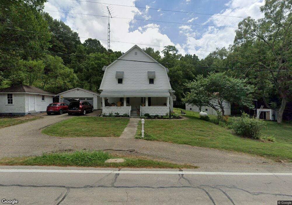
This home is located at 14136 State Route 93 S, Logan, OH 43138 and is currently estimated at $416,333, approximately $144 per square foot. 14136 State Route 93 S is a home located in Hocking County with nearby schools including Union Furnace Elementary School, Logan Christian School, and St. John the Evangelist School.
Ownership History
Date
Name
Owned For
Owner Type
Purchase Details
Closed on
Jan 1, 2023
Sold by
Rickmer Family Trust
Bought by
Craine Andrew J
Current Estimated Value
Home Financials for this Owner
Home Financials are based on the most recent Mortgage that was taken out on this home.
Original Mortgage
$200,000
Outstanding Balance
$193,481
Interest Rate
6.31%
Mortgage Type
New Conventional
Estimated Equity
$222,852
Purchase Details
Closed on
Jan 19, 2022
Sold by
Peterson Richard J and Peterson Merry C
Bought by
Rickmer Family Trust
Purchase Details
Closed on
Mar 13, 2007
Sold by
Hughes K Howard and Hughes Aurora
Bought by
Peterson Richard and Peterson Merry
Home Financials for this Owner
Home Financials are based on the most recent Mortgage that was taken out on this home.
Original Mortgage
$176,000
Interest Rate
6.27%
Mortgage Type
New Conventional
Create a Home Valuation Report for This Property
The Home Valuation Report is an in-depth analysis detailing your home's value as well as a comparison with similar homes in the area
Home Values in the Area
Average Home Value in this Area
Purchase History
| Date | Buyer | Sale Price | Title Company |
|---|---|---|---|
| Craine Andrew J | -- | Hocking Valley Title | |
| Rickmer Family Trust | -- | None Listed On Document | |
| Peterson Richard | $220,000 | None Available |
Source: Public Records
Mortgage History
| Date | Status | Borrower | Loan Amount |
|---|---|---|---|
| Open | Craine Andrew J | $200,000 | |
| Previous Owner | Peterson Richard | $176,000 |
Source: Public Records
Tax History Compared to Growth
Tax History
| Year | Tax Paid | Tax Assessment Tax Assessment Total Assessment is a certain percentage of the fair market value that is determined by local assessors to be the total taxable value of land and additions on the property. | Land | Improvement |
|---|---|---|---|---|
| 2024 | $431 | $11,190 | $11,190 | $0 |
| 2023 | $431 | $289,810 | $257,940 | $31,870 |
| 2022 | $2,209 | $57,230 | $25,360 | $31,870 |
| 2021 | $1,895 | $47,020 | $18,110 | $28,910 |
| 2020 | $1,887 | $47,020 | $18,110 | $28,910 |
| 2019 | $1,903 | $50,390 | $21,480 | $28,910 |
| 2018 | $1,680 | $42,850 | $13,940 | $28,910 |
| 2017 | $1,649 | $42,850 | $13,940 | $28,910 |
| 2016 | $1,637 | $42,850 | $13,940 | $28,910 |
| 2015 | $1,628 | $41,010 | $17,730 | $23,280 |
| 2014 | $1,628 | $41,010 | $17,730 | $23,280 |
| 2013 | $1,634 | $41,010 | $17,730 | $23,280 |
Source: Public Records
Map
Nearby Homes
- 0 Redbud Ln Unit LOT 62 224020754
- 32366 Lilac Ln
- 32268 Cedar Ln
- 743 Summit Dr
- 849 Mohican Ave
- 875 Walhonding Ave
- 111 Falls St
- 953 Marla Ave
- 28583 Hawthorne Way
- 787 Huntley Ave
- 741 Huntley Ave
- 1139 Old McArthur Rd
- 67 W Front St
- 597 Henrietta Ave
- 331 Short St
- 385 W Main St
- State Route 328
- 15050 Old McArthur Rd
- 150 Wood St
- 171 Warner Ave
- 14092 Hemlock Pkwy
- 14116 Hemlock Pkwy Unit Lot 49
- 14054 Hemlock Pkwy
- 14115 Hemlock Pkwy
- 14097 Hemlock Pkwy
- 14105 State Route 93 S
- 14035 Hemlock Pkwy
- 32321 Redbud Ln
- 32310 Redbud Ln
- 32356 Redbud Ln
- Lot 61 Redbud Ln
- Lot 60 Redbud Ln
- Lot 62 Redbud Ln
- Lot 63 Redbud Ln
- Lot 64 Redbud Ln
- Lot 57 Redbud Ln
- Lot 58 Redbud Ln
- Lot 59 Redbud Ln
- 0 Redbud Ln Unit 222009774
- 0 Redbud Ln Unit 221009554