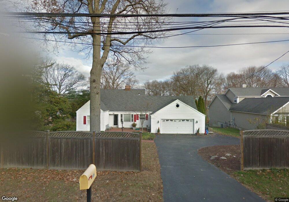
1414 N Benson Rd Fairfield, CT 06824
University NeighborhoodEstimated Value: $1,127,000 - $1,256,000
4
Beds
4
Baths
2,656
Sq Ft
$450/Sq Ft
Est. Value
About This Home
This home is located at 1414 N Benson Rd, Fairfield, CT 06824 and is currently estimated at $1,194,388, approximately $449 per square foot. 1414 N Benson Rd is a home located in Fairfield County with nearby schools including Osborn Hill Elementary School, Fairfield Woods Middle School, and Fairfield Ludlowe High School.
Ownership History
Date
Name
Owned For
Owner Type
Purchase Details
Closed on
Jan 15, 1999
Sold by
Brennan Sean J and Brennan Judith A
Bought by
Hahn Ann P and Hahn Ann D
Current Estimated Value
Purchase Details
Closed on
May 22, 1988
Sold by
Wanda Mazur Est
Bought by
Brennan Sean J
Create a Home Valuation Report for This Property
The Home Valuation Report is an in-depth analysis detailing your home's value as well as a comparison with similar homes in the area
Home Values in the Area
Average Home Value in this Area
Purchase History
| Date | Buyer | Sale Price | Title Company |
|---|---|---|---|
| Hahn Ann P | $365,900 | -- | |
| Hahn Ann P | $365,900 | -- | |
| Brennan Sean J | $230,000 | -- |
Source: Public Records
Mortgage History
| Date | Status | Borrower | Loan Amount |
|---|---|---|---|
| Open | Brennan Sean J | $160,000 | |
| Closed | Brennan Sean J | $160,000 | |
| Closed | Brennan Sean J | $155,000 |
Source: Public Records
Tax History Compared to Growth
Tax History
| Year | Tax Paid | Tax Assessment Tax Assessment Total Assessment is a certain percentage of the fair market value that is determined by local assessors to be the total taxable value of land and additions on the property. | Land | Improvement |
|---|---|---|---|---|
| 2025 | $12,679 | $446,600 | $317,450 | $129,150 |
| 2024 | $12,460 | $446,600 | $317,450 | $129,150 |
| 2023 | $12,286 | $446,600 | $317,450 | $129,150 |
| 2022 | $12,165 | $446,600 | $317,450 | $129,150 |
| 2021 | $12,049 | $446,600 | $317,450 | $129,150 |
| 2020 | $10,198 | $380,660 | $237,720 | $142,940 |
| 2019 | $10,198 | $380,660 | $237,720 | $142,940 |
| 2018 | $10,034 | $380,660 | $237,720 | $142,940 |
| 2017 | $9,829 | $380,660 | $237,720 | $142,940 |
| 2016 | $9,688 | $380,660 | $237,720 | $142,940 |
| 2015 | $9,981 | $402,640 | $250,180 | $152,460 |
| 2014 | $9,824 | $402,640 | $250,180 | $152,460 |
Source: Public Records
Map
Nearby Homes
- 45 Robin Cir
- 42 Robin Cir
- 44 Deer Run Rd
- 68 Figlar Ave
- 478 Crestwood Rd
- 359 Reid St
- 338 Orchard Hill Ln
- 105 Charter Oak Rd
- 1207 Stillson Rd
- 133 Green Acre Ln
- 2107 N Benson Rd
- 66 Adams Rd
- 109 Jeniford Rd
- 1165 Stillson Rd
- 1137 Stillson Rd
- 33 Middlebrook Place
- 115 Mayfair Rd
- 25 Millspaugh Dr
- 79 Mayfair Rd
- 15 Barton Rd
- 1436 N Benson Rd
- 1400 N Benson Rd
- 1356 N Benson Rd
- 1454 N Benson Rd
- 221 Knollwood Dr
- 47 Mailands Rd
- 1462 N Benson Rd
- 65 Mailands Rd
- 201 Knollwood Dr
- 241 Knollwood Dr
- 261 Knollwood Dr
- 181 Knollwood Dr
- 77 Mailands Rd
- 1320 N Benson Rd
- 55 Mailands Rd
- 301 Knollwood Dr
- 159 Knollwood Dr
- 1334 N Benson Rd
- 252 Knollwood Dr
- 200 Rock Major Rd