1415 Park St Palmer, MA 01069
Estimated payment $1,285/month
Highlights
- Pond View
- No HOA
- Level Lot
- 1.45 Acre Lot
- Property is near schools
About This Lot
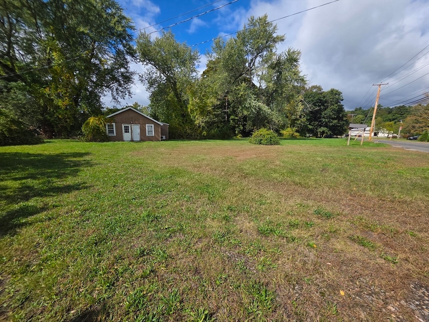
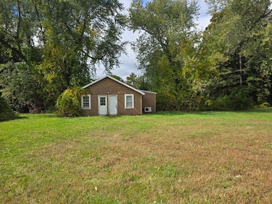
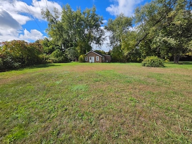
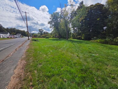
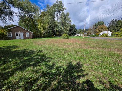
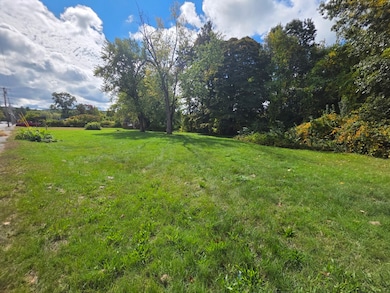
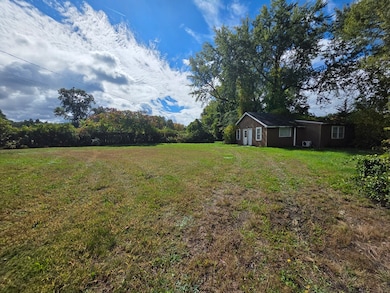
Opportunity awaits with this 1.45-acre parcel zoned General Business on Route 20 in Palmer! Backing up to a small body of water and offering great road frontage on well-traveled street Route 20 just minutes from the Mass Pike exit, this property delivers both convenience and a natural setting. The existing structure was previously used as an office and is in need of repair—could be ideal for a tear-down to start fresh or for a buyer ready to take on a full renovation project. While currently zoned General Business, this lot offers plenty of potential such as retail, offices, and a variety of other businesses, or could be for those looking to create a unique residential retreat or explore development options (buyer to confirm allowable uses with the town). With its size, visibility, and location, this land could be the perfect foundation for your next project.
Property Details
Property Type
- Land
Est. Annual Taxes
- $2,826
Lot Details
- 1.45 Acre Lot
- Level Lot
- Cleared Lot
- Property is zoned GB
Utilities
- Electricity To Lot Line
- Natural Gas Not Available
Additional Features
- Pond Views
- Property is near schools
Community Details
- No Home Owners Association
Listing and Financial Details
- Assessor Parcel Number M:2 B:96,3144558
Map
Home Values in the Area
Average Home Value in this Area
Tax History
| Year | Tax Paid | Tax Assessment Tax Assessment Total Assessment is a certain percentage of the fair market value that is determined by local assessors to be the total taxable value of land and additions on the property. | Land | Improvement |
|---|---|---|---|---|
| 2025 | $2,826 | $155,700 | $101,700 | $54,000 |
| 2024 | $2,647 | $141,800 | $92,500 | $49,300 |
| 2023 | $2,720 | $139,900 | $92,500 | $47,400 |
| 2022 | $2,688 | $125,600 | $81,300 | $44,300 |
| 2021 | $2,799 | $123,700 | $90,500 | $33,200 |
| 2020 | $2,820 | $123,700 | $90,500 | $33,200 |
| 2019 | $2,739 | $123,700 | $90,500 | $33,200 |
| 2018 | $2,656 | $120,300 | $87,800 | $32,500 |
| 2017 | $2,595 | $120,300 | $87,800 | $32,500 |
| 2016 | $2,559 | $120,300 | $85,200 | $35,100 |
| 2015 | $2,482 | $120,300 | $85,200 | $35,100 |
Property History
| Date | Event | Price | List to Sale | Price per Sq Ft |
|---|---|---|---|---|
| 10/23/2025 10/23/25 | Price Changed | $200,000 | -11.1% | -- |
| 09/26/2025 09/26/25 | For Sale | $225,000 | -- | -- |
Purchase History
| Date | Type | Sale Price | Title Company |
|---|---|---|---|
| Deed | $75,000 | -- | |
| Deed | $95,000 | -- |
Mortgage History
| Date | Status | Loan Amount | Loan Type |
|---|---|---|---|
| Previous Owner | $85,500 | Commercial | |
| Previous Owner | $4,750 | Commercial |
Source: MLS Property Information Network (MLS PIN)
MLS Number: 73436369
APN: PALM-000002-000000-000096
Disclaimer: Certain information contained herein is derived from information provided by parties other than Homes.com. All information provided is deemed reliable, but is not guaranteed to be accurate and should be independently verified.
![]() The property listing data and information, or the Images, set forth herein were provided to MLS Property Information Network, Inc. from third party sources, including sellers, lessors and public records, and were compiled by MLS Property Information Network, Inc. The property listing data and information, and the Images, are for the personal, non-commercial use of consumers having a good faith interest in purchasing or leasing listed properties of the type displayed to them and may not be used for any purpose other than to identify prospective properties which such consumers may have a good faith interest in purchasing or leasing. MLS Property Information Network, Inc. and its subscribers disclaim any and all representations and warranties as to the accuracy of the property listing data and information, or as to the accuracy of any of the Images, set forth herein.
The property listing data and information, or the Images, set forth herein were provided to MLS Property Information Network, Inc. from third party sources, including sellers, lessors and public records, and were compiled by MLS Property Information Network, Inc. The property listing data and information, and the Images, are for the personal, non-commercial use of consumers having a good faith interest in purchasing or leasing listed properties of the type displayed to them and may not be used for any purpose other than to identify prospective properties which such consumers may have a good faith interest in purchasing or leasing. MLS Property Information Network, Inc. and its subscribers disclaim any and all representations and warranties as to the accuracy of the property listing data and information, or as to the accuracy of any of the Images, set forth herein.
- 11 Allen St
- 268 Palmer Rd Unit 59
- 268 Palmer Rd Unit 44
- 268 Palmer Rd Unit 27
- 268 Palmer Rd Unit 2
- 7 Cedar Hill St
- 1 Pioneer Dr
- 160 Breckenridge St
- 72 Quaboag Valley Co Op St Unit 70
- 207 Breckenridge St
- 1018-1020 Maple St
- 98 Mason St
- 0 Flynt St
- 44 Converse St
- 135 Thompson St
- Lot 8 Breckenridge St
- 0 Palmer Rd
- L 65-35-1 Pine Hill Dr
- 0 St Unit 73414881
- 0 Hovey Rd
- 200 Brimfield Rd
- 24 Margaret St Unit 24L
- 4068 Hill St Unit 4068
- 371 Wilbraham St Unit 1
- 2020 Palmer Rd
- 2009 High St Unit 2013
- 1 Lariviere Ave
- 101 Minechoag Heights Unit 103
- 203 Wales Rd Unit A
- 77 W Main St
- 77 W Main St Unit 77 West Main Street
- 356 East St Unit 358
- 358 East St Unit 358
- 50 North St
- 93 Pleasant St Unit D
- 93 Pleasant St
- 93 Pleasant St
- 24 1/2 Pine St Unit A
- 20 Sherwin St Unit A
- 97 Winsor St Unit 10
