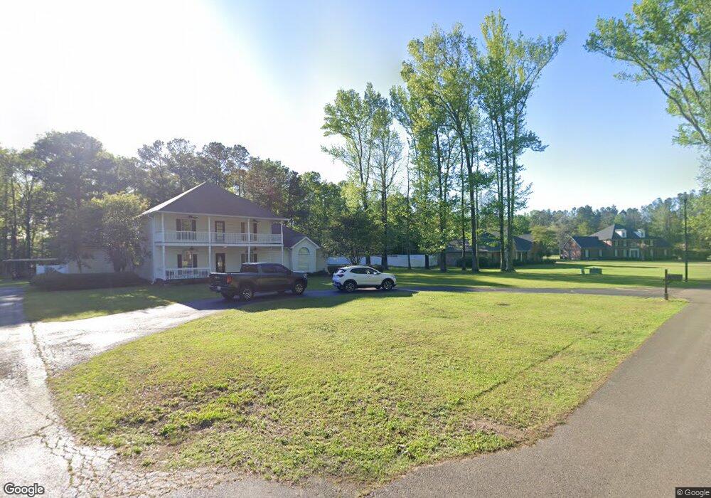
1415 Stevens Grove Rd West Point, MS 39773
Estimated Value: $387,000 - $597,000
4
Beds
--
Bath
3,848
Sq Ft
$122/Sq Ft
Est. Value
About This Home
This home is located at 1415 Stevens Grove Rd, West Point, MS 39773 and is currently estimated at $469,673, approximately $122 per square foot. 1415 Stevens Grove Rd is a home located in Clay County with nearby schools including East Side Elementary School, West Clay Elementary School, and Church Hill Elementary School.
Ownership History
Date
Name
Owned For
Owner Type
Purchase Details
Closed on
Jul 29, 2021
Sold by
Davis James K and Davis Patricia S
Bought by
Cowart William Ray and Cowart Amy Michele
Current Estimated Value
Home Financials for this Owner
Home Financials are based on the most recent Mortgage that was taken out on this home.
Original Mortgage
$309,294
Outstanding Balance
$280,027
Interest Rate
2.9%
Mortgage Type
FHA
Estimated Equity
$189,646
Create a Home Valuation Report for This Property
The Home Valuation Report is an in-depth analysis detailing your home's value as well as a comparison with similar homes in the area
Home Values in the Area
Average Home Value in this Area
Purchase History
| Date | Buyer | Sale Price | Title Company |
|---|---|---|---|
| Cowart William Ray | -- | None Available |
Source: Public Records
Mortgage History
| Date | Status | Borrower | Loan Amount |
|---|---|---|---|
| Open | Cowart William Ray | $309,294 |
Source: Public Records
Tax History Compared to Growth
Tax History
| Year | Tax Paid | Tax Assessment Tax Assessment Total Assessment is a certain percentage of the fair market value that is determined by local assessors to be the total taxable value of land and additions on the property. | Land | Improvement |
|---|---|---|---|---|
| 2024 | $1,622 | $32,679 | $4,500 | $28,179 |
| 2023 | $3,769 | $27,186 | $4,500 | $22,686 |
| 2022 | $1,332 | $27,186 | $4,500 | $22,686 |
| 2021 | $2,217 | $40,779 | $6,750 | $34,029 |
| 2020 | $2,216 | $40,779 | $6,750 | $34,029 |
| 2019 | $2,092 | $40,471 | $6,750 | $33,721 |
| 2018 | $965 | $26,981 | $4,500 | $22,481 |
| 2017 | $965 | $26,981 | $4,500 | $22,481 |
| 2016 | $928 | $26,981 | $4,500 | $22,481 |
| 2015 | $908 | $25,924 | $4,500 | $21,424 |
| 2014 | $963 | $25,924 | $4,500 | $21,424 |
| 2013 | $963 | $25,924 | $4,500 | $21,424 |
Source: Public Records
Map
Nearby Homes
- 0 Old Tibbee Rd
- 161 Mapleview Rd
- 219 Mapleview Rd
- 389 Mapleview Rd
- 15 David St
- 3986 E Church Hill Rd
- 1046 E Brame Ave
- 44 Torbert Dr
- 9 Scotland Yard
- 472 S Eshman Ave
- 249 Waverly Dr
- 329 Converse Dr
- 223 Waverly Dr
- 402 Cromwell St
- 346 E Brame Ave
- 278 Converse Dr
- 164 Belvedere Ave
- 145 Waverly Dr
- 238 Calhoun St
- Lot 31 Waverly Dr
- 1419 Stevens Grove Rd
- 1417 Stevens Grove Rd
- 1405 Stevens Grove Rd
- 425 Stevens Grove Rd
- 1407 Stevens Grove Rd
- 235 Stevens Grove Rd
- 716 Waverly Rd
- 1409 Stevens Grove Rd
- 640 Waverly Rd
- 278 Stevens Grove Rd
- 693 Waverly Rd
- 547 Waverly Rd
- 1015 Waverly Rd
- 1068 Section Cir
- 4040 Old Tibbee Rd
- 1230 Hickory Dr
- 305 Section Cir
- 1218 Hickory Dr
- 1232 Hickory Dr
- 1211 Hickory Dr