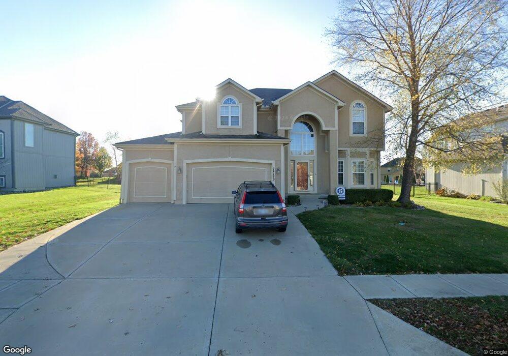
14150 Belrive Cir Basehor, KS 66007
Estimated Value: $607,000 - $734,000
5
Beds
5
Baths
2,710
Sq Ft
$241/Sq Ft
Est. Value
About This Home
This home is located at 14150 Belrive Cir, Basehor, KS 66007 and is currently estimated at $654,147, approximately $241 per square foot. 14150 Belrive Cir is a home located in Leavenworth County with nearby schools including Basehor Elementary School, Basehor-Linwood Middle School, and Basehor-Linwood High School.
Ownership History
Date
Name
Owned For
Owner Type
Purchase Details
Closed on
Jan 16, 2008
Sold by
J Right Inc
Bought by
Guerra Jose and Guerra Sharon
Current Estimated Value
Home Financials for this Owner
Home Financials are based on the most recent Mortgage that was taken out on this home.
Original Mortgage
$318,100
Outstanding Balance
$200,267
Interest Rate
6.11%
Mortgage Type
New Conventional
Estimated Equity
$453,880
Create a Home Valuation Report for This Property
The Home Valuation Report is an in-depth analysis detailing your home's value as well as a comparison with similar homes in the area
Home Values in the Area
Average Home Value in this Area
Purchase History
| Date | Buyer | Sale Price | Title Company |
|---|---|---|---|
| Guerra Jose | $423,073 | Stewart Title |
Source: Public Records
Mortgage History
| Date | Status | Borrower | Loan Amount |
|---|---|---|---|
| Open | Guerra Jose | $318,100 |
Source: Public Records
Tax History Compared to Growth
Tax History
| Year | Tax Paid | Tax Assessment Tax Assessment Total Assessment is a certain percentage of the fair market value that is determined by local assessors to be the total taxable value of land and additions on the property. | Land | Improvement |
|---|---|---|---|---|
| 2025 | $9,116 | $65,605 | $10,711 | $54,894 |
| 2024 | $8,577 | $63,694 | $10,711 | $52,983 |
| 2023 | $8,577 | $62,445 | $9,216 | $53,229 |
| 2022 | $7,830 | $54,453 | $7,419 | $47,034 |
| 2021 | $7,249 | $50,531 | $7,419 | $43,112 |
| 2020 | $7,248 | $49,657 | $7,419 | $42,238 |
| 2019 | $7,168 | $49,657 | $4,706 | $44,951 |
| 2018 | $7,155 | $45,747 | $4,706 | $41,041 |
| 2017 | $6,752 | $42,760 | $4,706 | $38,054 |
| 2016 | $6,388 | $40,469 | $4,706 | $35,763 |
| 2015 | $6,197 | $40,469 | $4,706 | $35,763 |
| 2014 | $5,814 | $38,128 | $3,988 | $34,140 |
Source: Public Records
Map
Nearby Homes
- 4310 N 141st Place
- 4418 Tee Box Dr
- 4151 Lake Shore Dr
- 4145 Lake Shore Dr
- 4248 Lake Shore Dr
- 4250 Aspen Dr
- 4270 Lake Shore Dr
- 4417 N 141st St
- 4271 Aspen Dr
- The Azalea I Plan at The Communities of Falcon Lakes - Falcon Lakes
- 14574 Aurora Ln
- 4282 Lake Shore Dr
- 4377 Tee Box Dr
- 4343-4501 N 139th St
- Yorkshire V Plan at The Communities of Falcon Lakes - The Communities at Falcon Lakes
- Ashwood Plan at The Communities of Falcon Lakes - The Communities at Falcon Lakes
- Cypress II Plan at The Communities of Falcon Lakes - The Communities at Falcon Lakes
- The York Plan at The Communities of Falcon Lakes - The Communties of Falcon Lakes
- The Wyndham V Plan at The Communities of Falcon Lakes - The Communties of Falcon Lakes
- The Wyndham II Plan at The Communities of Falcon Lakes - The Communties of Falcon Lakes
- 14144 Belrive Cir
- 14154 Belrive Cir
- 0 Belrive Cir
- 4108 N 141st St
- 14160 Belrive Cir
- 14138 Belrive Cir
- 14110 Belrive Cir
- 14108 Belrive Cir
- 14147 Belrive Cir
- 14151 Belrive Cir
- 4112 N 141st St
- 4106 N 141st St
- 14155 Belrive Cir
- 14143 Belrive Cir
- 14104 Belrive Cir
- 4116 N 141st St
- 14159 Belrive Cir
- 14139 Belrive Cir
- 4100 N 141st St
- 14163 Belrive Cir