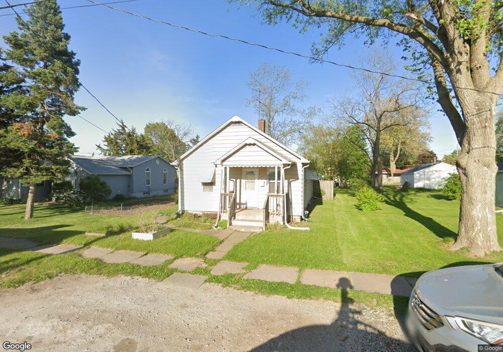
1419 1st Ave Muscatine, IA 52761
Estimated Value: $102,000 - $111,000
2
Beds
1
Bath
880
Sq Ft
$120/Sq Ft
Est. Value
About This Home
This home is located at 1419 1st Ave, Muscatine, IA 52761 and is currently estimated at $105,277, approximately $119 per square foot. 1419 1st Ave is a home located in Muscatine County with nearby schools including Madison Elementary School, Central Middle School, and Susan Clark Junior High School.
Ownership History
Date
Name
Owned For
Owner Type
Purchase Details
Closed on
Oct 13, 2023
Sold by
Roos Diaan and Roos Michelle
Bought by
Roos Real Estate Llc
Current Estimated Value
Purchase Details
Closed on
Mar 14, 2017
Sold by
Genung Brittany N and Alfanso Roberto
Bought by
Roos Michelle
Purchase Details
Closed on
Mar 20, 2009
Sold by
Wakeland Toni L
Bought by
Genung Joshua L and Genung Brittany N
Home Financials for this Owner
Home Financials are based on the most recent Mortgage that was taken out on this home.
Original Mortgage
$73,107
Interest Rate
5.2%
Mortgage Type
FHA
Purchase Details
Closed on
Sep 22, 2008
Sold by
Wakeland Josep T
Bought by
Wakeland Toni L
Create a Home Valuation Report for This Property
The Home Valuation Report is an in-depth analysis detailing your home's value as well as a comparison with similar homes in the area
Home Values in the Area
Average Home Value in this Area
Purchase History
| Date | Buyer | Sale Price | Title Company |
|---|---|---|---|
| Roos Real Estate Llc | -- | None Listed On Document | |
| Roos Michelle | $54,300 | None Available | |
| Genung Joshua L | $74,500 | None Available | |
| Wakeland Toni L | -- | None Available |
Source: Public Records
Mortgage History
| Date | Status | Borrower | Loan Amount |
|---|---|---|---|
| Previous Owner | Genung Joshua L | $73,107 |
Source: Public Records
Tax History Compared to Growth
Tax History
| Year | Tax Paid | Tax Assessment Tax Assessment Total Assessment is a certain percentage of the fair market value that is determined by local assessors to be the total taxable value of land and additions on the property. | Land | Improvement |
|---|---|---|---|---|
| 2025 | $1,590 | $87,020 | $11,390 | $75,630 |
| 2024 | $1,590 | $87,650 | $11,390 | $76,260 |
| 2023 | $1,690 | $97,064 | $11,374 | $85,690 |
| 2022 | $1,666 | $84,360 | $10,730 | $73,630 |
| 2021 | $1,666 | $81,650 | $10,730 | $70,920 |
| 2020 | $1,486 | $76,190 | $10,730 | $65,460 |
| 2019 | $1,564 | $70,760 | $0 | $0 |
| 2018 | $1,540 | $70,650 | $0 | $0 |
| 2017 | $1,540 | $68,840 | $0 | $0 |
| 2016 | $1,360 | $68,840 | $0 | $0 |
| 2015 | $1,360 | $68,190 | $0 | $0 |
| 2014 | $1,354 | $68,190 | $0 | $0 |
Source: Public Records
Map
Nearby Homes
- 1416 Lincoln Blvd
- 1414 Lincoln Blvd
- 416 Jackson St
- 1509 Lincoln Blvd
- 514 Jackson St
- 1507 Grand Ave
- 504 Adams St
- 318 Monroe St
- 1707 Lincoln Blvd
- 630 Jackson St
- 2016 Lincoln Blvd
- 0 Fillmore St Parcel
- 503 Mcarthur St
- 613 Lake Park Blvd
- 1903 Park Ave
- 1903 Park Ave
- 1554 Washington St
- 1708 Cobblestone Dr
- 140 Sheridan St
- 1110 E 10th St