Estimated Value: $223,000 - $237,000
3
Beds
2
Baths
1,386
Sq Ft
$165/Sq Ft
Est. Value
About This Home
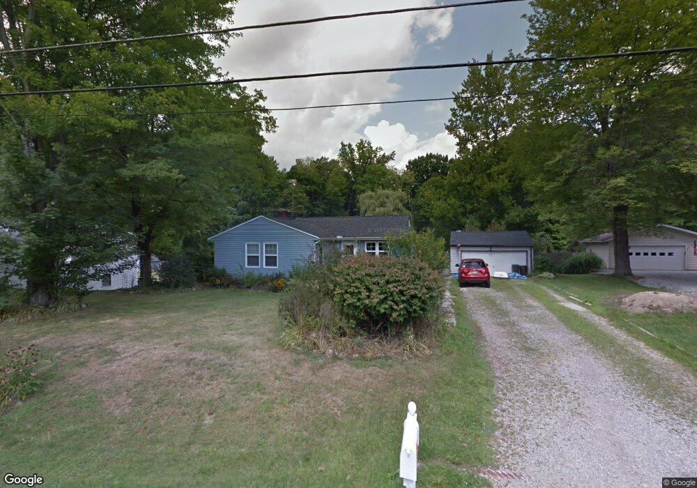
This home is located at 1419 Mctaggart Rd, Stow, OH 44224 and is currently estimated at $228,796, approximately $165 per square foot. 1419 Mctaggart Rd is a home located in Summit County with nearby schools including Stow-Munroe Falls High School, Primrose School of Hudson, and Holy Family Elementary School.
Ownership History
Date
Name
Owned For
Owner Type
Purchase Details
Closed on
Mar 22, 2005
Sold by
Prudential Residential Services Lp
Bought by
Desessa Erin M and Desessa Heather A
Current Estimated Value
Home Financials for this Owner
Home Financials are based on the most recent Mortgage that was taken out on this home.
Original Mortgage
$124,200
Outstanding Balance
$62,966
Interest Rate
5.61%
Mortgage Type
Purchase Money Mortgage
Estimated Equity
$165,830
Purchase Details
Closed on
Mar 8, 2005
Sold by
Penberthy Thomas R and Santora Joyce A
Bought by
Prudential Residential Services Lp
Home Financials for this Owner
Home Financials are based on the most recent Mortgage that was taken out on this home.
Original Mortgage
$124,200
Outstanding Balance
$62,966
Interest Rate
5.61%
Mortgage Type
Purchase Money Mortgage
Estimated Equity
$165,830
Purchase Details
Closed on
Aug 8, 1995
Sold by
Shrf Arthur C Coffey Pr
Bought by
Penberthy Thomas R and Santora Joyce A
Create a Home Valuation Report for This Property
The Home Valuation Report is an in-depth analysis detailing your home's value as well as a comparison with similar homes in the area
Home Values in the Area
Average Home Value in this Area
Purchase History
| Date | Buyer | Sale Price | Title Company |
|---|---|---|---|
| Desessa Erin M | $138,000 | Chicago Title Insurance Comp | |
| Prudential Residential Services Lp | $138,000 | Chicago Title Insurance Comp | |
| Penberthy Thomas R | $69,000 | -- |
Source: Public Records
Mortgage History
| Date | Status | Borrower | Loan Amount |
|---|---|---|---|
| Open | Desessa Erin M | $124,200 |
Source: Public Records
Tax History
| Year | Tax Paid | Tax Assessment Tax Assessment Total Assessment is a certain percentage of the fair market value that is determined by local assessors to be the total taxable value of land and additions on the property. | Land | Improvement |
|---|---|---|---|---|
| 2024 | $3,273 | $57,684 | $11,333 | $46,351 |
| 2023 | $3,273 | $57,684 | $11,333 | $46,351 |
| 2022 | $3,037 | $47,226 | $9,216 | $38,010 |
| 2021 | $2,721 | $47,226 | $9,216 | $38,010 |
| 2020 | $2,675 | $47,230 | $9,220 | $38,010 |
| 2019 | $2,738 | $45,220 | $11,570 | $33,650 |
| 2018 | $2,693 | $45,220 | $11,570 | $33,650 |
| 2017 | $2,603 | $45,220 | $11,570 | $33,650 |
| 2016 | $2,679 | $42,460 | $11,570 | $30,890 |
| 2015 | $2,603 | $42,460 | $11,570 | $30,890 |
| 2014 | $2,606 | $42,460 | $11,570 | $30,890 |
| 2013 | $2,428 | $39,750 | $11,570 | $28,180 |
Source: Public Records
Map
Nearby Homes
- 1525 Spruce Hill Dr
- 0 Hibbard Dr
- 5123 Sodalite Dr
- 4623 Cox Dr
- 5091 Ridge Meadow Dr
- 2279 Becket Cir
- 2352 Becket Cir
- 1921-1929 Ritchie Rd
- V/L Norton Rd
- 5150 Bayside Lake Blvd
- V/L Housley Rd
- 2221 Crockett Cir
- 1953 Arndale Rd
- 5163 Beckett Ridge
- 1995 Weston Dr
- 4424 Timberdale Dr Unit 4428
- 734 Barlow Rd
- 5866 Ogilby Dr
- 2055-2059 Bryn Mawr Dr
- 2344 Echo Valley Dr
- 1429 Mctaggart Rd
- 1422 Mctaggart Rd
- 1418 Mctaggart Rd Unit 1422
- 1412 Mctaggart Rd
- 1395 Mctaggart Rd Unit 1397
- 1428 Mctaggart Rd
- 1408 Mctaggart Rd Unit 1412
- 1439 Mctaggart Rd
- 1440 Mctaggart Rd
- 1447 Mctaggart Rd
- 1451 Mctaggart Rd
- 1387 Mctaggart Rd
- 1385 Mctaggart Rd Unit 1387
- 1345 Mac Dr
- 1381 Mac Dr
- 1460 Mctaggart Rd
- 1391 Mac Dr
- 1457 Mctaggart Rd
- 1464 Mctaggart Rd Unit 1466
- 1343 Mac Dr
Your Personal Tour Guide
Ask me questions while you tour the home.