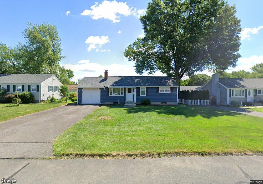
142 Brookside Cir Wethersfield, CT 06109
Estimated Value: $214,000 - $315,848
3
Beds
1
Bath
888
Sq Ft
$313/Sq Ft
Est. Value
About This Home
This home is located at 142 Brookside Cir, Wethersfield, CT 06109 and is currently estimated at $277,962, approximately $313 per square foot. 142 Brookside Cir is a home located in Hartford County with nearby schools including Emerson-Williams School, Silas Deane Middle School, and Wethersfield High School.
Ownership History
Date
Name
Owned For
Owner Type
Purchase Details
Closed on
Dec 30, 2005
Sold by
Est Philippon Jane E and Schoenborn Odila J
Bought by
Philippon Peter F
Current Estimated Value
Home Financials for this Owner
Home Financials are based on the most recent Mortgage that was taken out on this home.
Original Mortgage
$99,000
Interest Rate
6.39%
Purchase Details
Closed on
Sep 17, 2001
Sold by
Bouzko Anna Marie
Bought by
Philippon Jane M
Purchase Details
Closed on
Oct 30, 1992
Sold by
Fastiggi David F and Defilippo Ann
Bought by
Satterlee Anna Marie and Satterlee Theresa
Purchase Details
Closed on
Jul 16, 1990
Sold by
Prain Wanda
Bought by
Fastiggi David
Create a Home Valuation Report for This Property
The Home Valuation Report is an in-depth analysis detailing your home's value as well as a comparison with similar homes in the area
Home Values in the Area
Average Home Value in this Area
Purchase History
| Date | Buyer | Sale Price | Title Company |
|---|---|---|---|
| Philippon Peter F | $110,000 | -- | |
| Philippon Jane M | $145,000 | -- | |
| Satterlee Anna Marie | $140,000 | -- | |
| Fastiggi David | $128,500 | -- |
Source: Public Records
Mortgage History
| Date | Status | Borrower | Loan Amount |
|---|---|---|---|
| Open | Fastiggi David | $184,500 | |
| Closed | Fastiggi David | $99,000 | |
| Previous Owner | Fastiggi David | $15,000 |
Source: Public Records
Tax History
| Year | Tax Paid | Tax Assessment Tax Assessment Total Assessment is a certain percentage of the fair market value that is determined by local assessors to be the total taxable value of land and additions on the property. | Land | Improvement |
|---|---|---|---|---|
| 2025 | $7,287 | $176,780 | $63,170 | $113,610 |
| 2024 | $5,156 | $119,290 | $57,520 | $61,770 |
| 2023 | $4,984 | $119,290 | $57,520 | $61,770 |
| 2022 | $4,900 | $119,290 | $57,520 | $61,770 |
| 2021 | $4,852 | $119,290 | $57,520 | $61,770 |
| 2020 | $4,854 | $119,290 | $57,520 | $61,770 |
| 2019 | $4,860 | $119,290 | $57,520 | $61,770 |
| 2018 | $4,555 | $111,700 | $54,200 | $57,500 |
| 2017 | $4,442 | $111,700 | $54,200 | $57,500 |
| 2016 | $4,305 | $111,700 | $54,200 | $57,500 |
| 2015 | $4,266 | $111,700 | $54,200 | $57,500 |
| 2014 | $4,104 | $111,700 | $54,200 | $57,500 |
Source: Public Records
Map
Nearby Homes
- 1 Brussels Ave
- 19 Albert Ave
- 1 Bristol St
- 219-221 Jordan Ln
- 192 Wolcott Hill Rd
- 295 Ridge Rd Unit 8
- 55 Rutledge Rd
- 166 George St
- 28 Bolton St
- 144 Brown St
- 107 Harmund Place
- 43 Yale St
- 51 Hanmer St
- 23 Hillcrest Ave
- 18 Avalon Place
- 208 Mountain St
- 183-185 Cheshire St
- 167 Campfield Ave
- 317-319 Garden St
- 1 Fernwood St
- 132 Brookside Cir
- 148 Brookside Cir
- 21 Brookside Cir
- 27 Brookside Cir
- 17 Brookside Cir
- 128 Brookside Cir
- 154 Brookside Cir
- 141 Brookside Cir
- 133 Brookside Cir
- 33 Brookside Cir
- 147 Brookside Cir
- 11 Brookside Cir
- 127 Brookside Cir
- 122 Brookside Cir
- 149 Brookside Cir
- 39 Brookside Cir
- 391 Jordan Ln
- 387 Jordan Ln
- 22 Brookside Cir
- 16 Brookside Cir
Your Personal Tour Guide
Ask me questions while you tour the home.