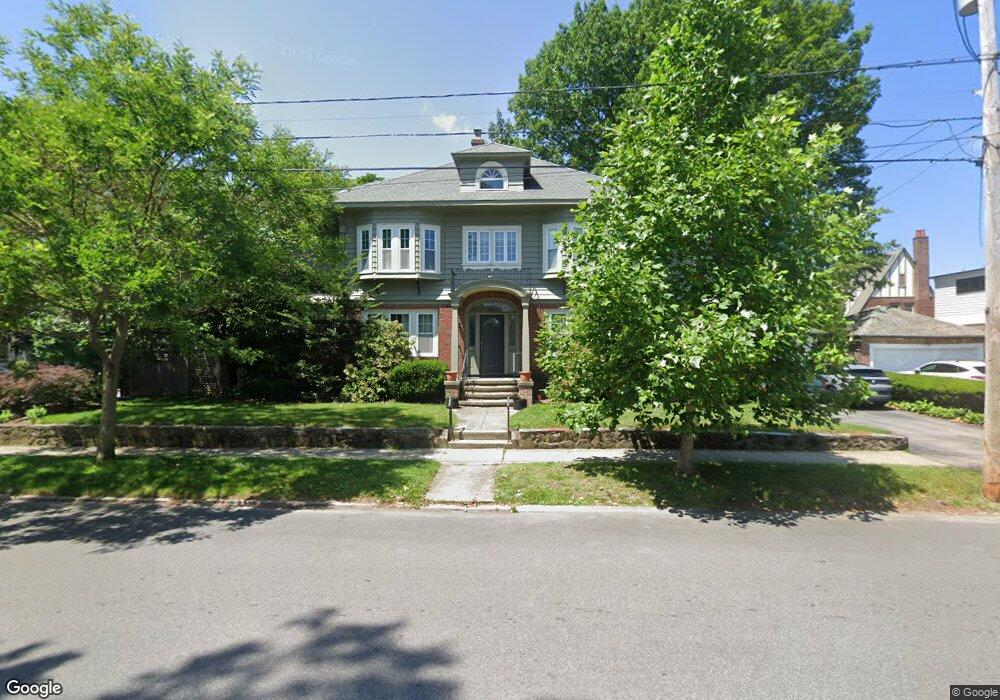
142 Cole Ave Providence, RI 02906
Blackstone NeighborhoodEstimated Value: $1,467,000 - $1,564,000
3
Beds
3
Baths
3,085
Sq Ft
$487/Sq Ft
Est. Value
About This Home
This home is located at 142 Cole Ave, Providence, RI 02906 and is currently estimated at $1,503,191, approximately $487 per square foot. 142 Cole Ave is a home located in Providence County with nearby schools including Asa Messer Elementary School, Charles N. Fortes Elementary School, and Veazie Street Elementary School.
Ownership History
Date
Name
Owned For
Owner Type
Purchase Details
Closed on
Jun 1, 2011
Sold by
Goacharov Alexander B and Goacharova Yelena
Bought by
Resta Giuseppe
Current Estimated Value
Home Financials for this Owner
Home Financials are based on the most recent Mortgage that was taken out on this home.
Original Mortgage
$376,000
Interest Rate
4.85%
Mortgage Type
Purchase Money Mortgage
Purchase Details
Closed on
May 28, 1999
Sold by
Marcovich Shlomo P and Marcovich Nina
Bought by
Goncharou Alexander B and Goncharou Yelena
Create a Home Valuation Report for This Property
The Home Valuation Report is an in-depth analysis detailing your home's value as well as a comparison with similar homes in the area
Home Values in the Area
Average Home Value in this Area
Purchase History
| Date | Buyer | Sale Price | Title Company |
|---|---|---|---|
| Resta Giuseppe | $470,000 | -- | |
| Goncharou Alexander B | $321,000 | -- |
Source: Public Records
Mortgage History
| Date | Status | Borrower | Loan Amount |
|---|---|---|---|
| Open | Goncharou Alexander B | $149,900 | |
| Open | Goncharou Alexander B | $372,162 | |
| Closed | Goncharou Alexander B | $376,000 | |
| Closed | Goncharou Alexander B | $376,000 |
Source: Public Records
Tax History Compared to Growth
Tax History
| Year | Tax Paid | Tax Assessment Tax Assessment Total Assessment is a certain percentage of the fair market value that is determined by local assessors to be the total taxable value of land and additions on the property. | Land | Improvement |
|---|---|---|---|---|
| 2025 | $10,805 | $1,286,300 | $547,000 | $739,300 |
| 2024 | $19,117 | $1,041,800 | $365,300 | $676,500 |
| 2023 | $19,117 | $1,041,800 | $365,300 | $676,500 |
| 2022 | $18,544 | $1,041,800 | $365,300 | $676,500 |
| 2021 | $19,415 | $790,500 | $292,000 | $498,500 |
| 2020 | $17,280 | $703,600 | $292,000 | $411,600 |
| 2019 | $17,280 | $703,600 | $292,000 | $411,600 |
| 2018 | $19,023 | $595,200 | $265,500 | $329,700 |
| 2017 | $17,054 | $533,600 | $265,500 | $268,100 |
| 2016 | $17,054 | $533,600 | $265,500 | $268,100 |
| 2015 | $16,596 | $501,400 | $256,200 | $245,200 |
| 2014 | $16,922 | $501,400 | $256,200 | $245,200 |
| 2013 | $16,922 | $501,400 | $256,200 | $245,200 |
Source: Public Records
Map
Nearby Homes
- 189 Laurel Ave Unit 189
- 160 Slater Ave
- 234 President Ave Unit 16
- 188 Blackstone Blvd
- 140 Freeman Pkwy
- 22 Miles Ave Unit 1
- 134 Irving Ave
- 184 Irving Ave Unit 1
- 80 Clarendon Ave
- 294 Cole Ave
- 296 Cole Ave
- 125 Taber Ave
- 141 Elton St
- 201 Arlington Ave
- 360 Taber Ave
- 41 Stadium Rd
- 41 Taber Ave
- 537 Angell St Unit 3
- 30 S Angell St Unit 2
- 20 Taber Ave
- 186 Laurel Ave
- 235 Freeman Pkwy
- 187 Laurel Ave
- 187 Laurel Ave Unit 2
- 198 Laurel Ave
- 185 Laurel Ave
- 189 Laurel Ave
- 185 Laurel Ave Unit 3
- 189 Laurel Ave Unit 1
- 182 Laurel Ave
- 141 Cole Ave
- 225 Freeman Pkwy
- 183 Laurel Ave
- 133 Cole Ave
- 205 Laurel Ave
- 181 Laurel Ave
- 181 Laurel Ave Unit 5
- 177 Laurel Ave
- 179 Laurel Ave
- 175 Laurel Ave