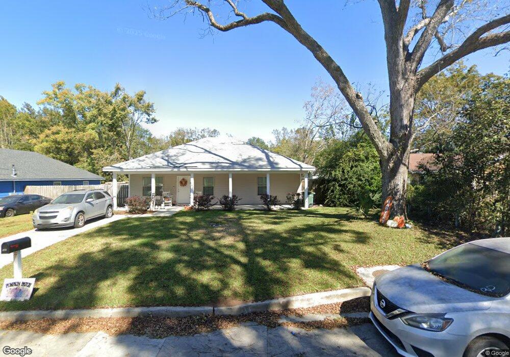
142 Darling St Savannah, GA 31408
Woodville NeighborhoodEstimated Value: $236,000 - $259,839
3
Beds
2
Baths
--
Sq Ft
8,276
Sq Ft Lot
About This Home
This home is located at 142 Darling St, Savannah, GA 31408 and is currently estimated at $248,710. 142 Darling St is a home located in Chatham County with nearby schools including Otis J. Brock, III Elementary School, Mercer Middle School, and Groves High School.
Ownership History
Date
Name
Owned For
Owner Type
Purchase Details
Closed on
Dec 19, 2022
Sold by
The Coastal Empire Habitat For Humanity
Bought by
Jackson Brittany D
Current Estimated Value
Home Financials for this Owner
Home Financials are based on the most recent Mortgage that was taken out on this home.
Original Mortgage
$20,000
Outstanding Balance
$19,333
Interest Rate
6.61%
Mortgage Type
New Conventional
Estimated Equity
$229,377
Purchase Details
Closed on
Apr 30, 2020
Sold by
Chatham County City Of Savannah Land Ban
Bought by
The Coastal Empire Habitat For Humanity
Purchase Details
Closed on
Jul 1, 2008
Sold by
Not Provided
Bought by
Chatham County City Of Savanna and Land Bank Authority Inc
Create a Home Valuation Report for This Property
The Home Valuation Report is an in-depth analysis detailing your home's value as well as a comparison with similar homes in the area
Home Values in the Area
Average Home Value in this Area
Purchase History
| Date | Buyer | Sale Price | Title Company |
|---|---|---|---|
| Jackson Brittany D | $210,000 | -- | |
| The Coastal Empire Habitat For Humanity | $25,000 | -- | |
| Chatham County City Of Savanna | -- | -- |
Source: Public Records
Mortgage History
| Date | Status | Borrower | Loan Amount |
|---|---|---|---|
| Open | Jackson Brittany D | $20,000 | |
| Closed | Jackson Brittany D | $7,000 |
Source: Public Records
Tax History
| Year | Tax Paid | Tax Assessment Tax Assessment Total Assessment is a certain percentage of the fair market value that is determined by local assessors to be the total taxable value of land and additions on the property. | Land | Improvement |
|---|---|---|---|---|
| 2025 | $2,486 | $83,880 | $16,000 | $67,880 |
| 2024 | $23 | $82,480 | $16,000 | $66,480 |
| 2023 | $2,307 | $79,000 | $10,400 | $68,600 |
| 2022 | $0 | $5,200 | $5,200 | $0 |
| 2021 | $0 | $5,200 | $5,200 | $0 |
| 2020 | $0 | $5,200 | $5,200 | $0 |
| 2019 | $0 | $5,200 | $5,200 | $0 |
| 2018 | $0 | $5,200 | $5,200 | $0 |
| 2017 | $0 | $5,200 | $5,200 | $0 |
| 2016 | -- | $5,200 | $5,200 | $0 |
| 2015 | -- | $5,240 | $5,240 | $0 |
| 2014 | -- | $5,240 | $0 | $0 |
Source: Public Records
Map
Nearby Homes
- 118 King St
- 156 Darling St
- 121 King St
- 124 Wright St
- 248 Fair St
- 121 Roberts St
- 0 Old Louisville Rd Unit SA333709
- 0 Fair St
- 4124 4th St
- 110 W Lathrop Ave
- 1725 Dunn St
- 259 Brittany St
- 1723 Dunn St
- 1711 Stratford St
- 2016 Eppinger St
- 221 Baker St
- 2114 Weldon St
- O U S 80
- 306 Chatham Villa Dr
- 229 Millen St
Your Personal Tour Guide
Ask me questions while you tour the home.