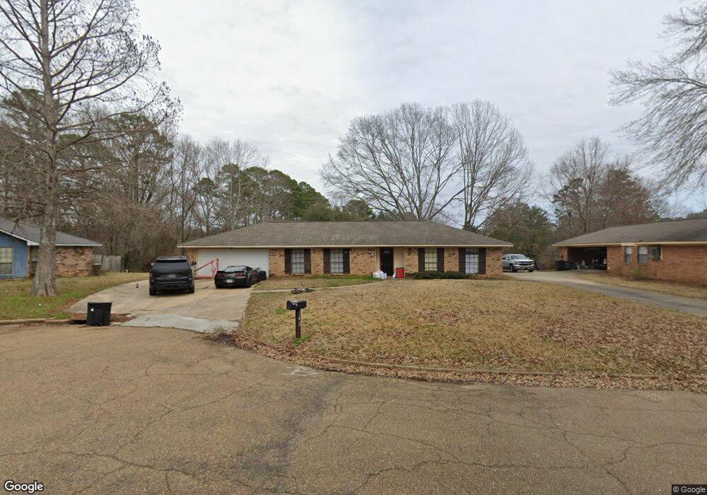
142 Long Meadow Rd Brandon, MS 39042
Estimated Value: $250,881 - $266,000
4
Beds
2
Baths
1,978
Sq Ft
$130/Sq Ft
Est. Value
About This Home
This home is located at 142 Long Meadow Rd, Brandon, MS 39042 and is currently estimated at $257,970, approximately $130 per square foot. 142 Long Meadow Rd is a home located in Rankin County with nearby schools including Rouse Elementary School, Brandon Elementary School, and Stonebridge Elementary School.
Ownership History
Date
Name
Owned For
Owner Type
Purchase Details
Closed on
Sep 22, 2021
Sold by
Mccann Daniel Aaron and Mccann Cynthia S
Bought by
Bsfr Iii Owner I Llc
Current Estimated Value
Purchase Details
Closed on
Dec 27, 2017
Sold by
Mccann Daniel Aaron
Bought by
Mccann Daniel Aaron and Mccann Cynthia Sue
Purchase Details
Closed on
Nov 17, 2014
Sold by
Evans James Odell
Bought by
Turnure Janet Evans and Sieving Sheila Evans
Purchase Details
Closed on
Dec 6, 2011
Sold by
Evans James Odell
Bought by
Evans Turnure Janet Evans and Evans Sueving Sheila
Purchase Details
Closed on
Apr 29, 2010
Sold by
Jean Tommie Jean Tommie
Bought by
Evans James Odell and Chapman Tommie Jean
Create a Home Valuation Report for This Property
The Home Valuation Report is an in-depth analysis detailing your home's value as well as a comparison with similar homes in the area
Home Values in the Area
Average Home Value in this Area
Purchase History
| Date | Buyer | Sale Price | Title Company |
|---|---|---|---|
| Bsfr Iii Owner I Llc | -- | None Listed On Document | |
| Mccann Daniel Aaron | -- | None Available | |
| Turnure Janet Evans | -- | None Available | |
| Evans Turnure Janet Evans | -- | -- | |
| Evans James Odell | -- | -- |
Source: Public Records
Tax History
| Year | Tax Paid | Tax Assessment Tax Assessment Total Assessment is a certain percentage of the fair market value that is determined by local assessors to be the total taxable value of land and additions on the property. | Land | Improvement |
|---|---|---|---|---|
| 2024 | $3,121 | $23,909 | $0 | $0 |
| 2023 | $2,503 | $19,175 | $0 | $0 |
| 2022 | $2,474 | $19,175 | $0 | $0 |
| 2021 | $1,349 | $12,783 | $0 | $0 |
| 2020 | $1,349 | $12,783 | $0 | $0 |
| 2019 | $1,521 | $11,479 | $0 | $0 |
| 2018 | $1,190 | $11,479 | $0 | $0 |
| 2017 | $2,235 | $17,219 | $0 | $0 |
| 2016 | $2,011 | $16,646 | $0 | $0 |
| 2015 | $434 | $11,097 | $0 | $0 |
| 2014 | $427 | $11,097 | $0 | $0 |
| 2013 | -- | $11,097 | $0 | $0 |
Source: Public Records
Map
Nearby Homes
- 100 Fairdale Place
- 111 Hickory Hill Place
- 705 Heartwood Ln
- 104 Shelby Mae Cir
- 119 Fern Valley Rd
- 116 Oakhill Place
- 102 Sunline Dr
- 92 Fern Valley Rd
- 123 Woodgate Dr
- 36 Pebble Hill Dr
- 135 Fawnwood Dr
- 0 Luckney Rd Unit 4087485
- 0 Quail Hill Rd Unit 4137695
- 1230 Crossview Ct
- 70 Crossgates Dr
- 22 Pebble Hill Dr
- 66 Terrapin Dr
- 501 Asbury Lane Dr
- 2046 S Cobblestone Cove
- 0 Asbury Lane Dr Unit 4124886
- 142 Longmeadow Rd
- 140 Long Meadow Rd
- 179 Summit Ridge Dr
- 175 Summit Ridge Dr
- 174 Summit Ridge Dr
- 137 Ridge Cove
- 173 Summit Ridge Dr
- 138 Long Meadow Rd
- 139 Longmeadow Rd
- 139 Long Meadow Rd
- 172 Summit Ridge Dr
- 133 Ridge Cove
- 171 Summit Ridge Dr
- 137 Long Meadow Rd
- 136 Long Meadow Rd
- 134 Ridge Cove
- 103 Ridge Rd
- 136 Ridge Cove
- 126 Post Hill Cove
- 170 Summit Ridge Dr
Your Personal Tour Guide
Ask me questions while you tour the home.