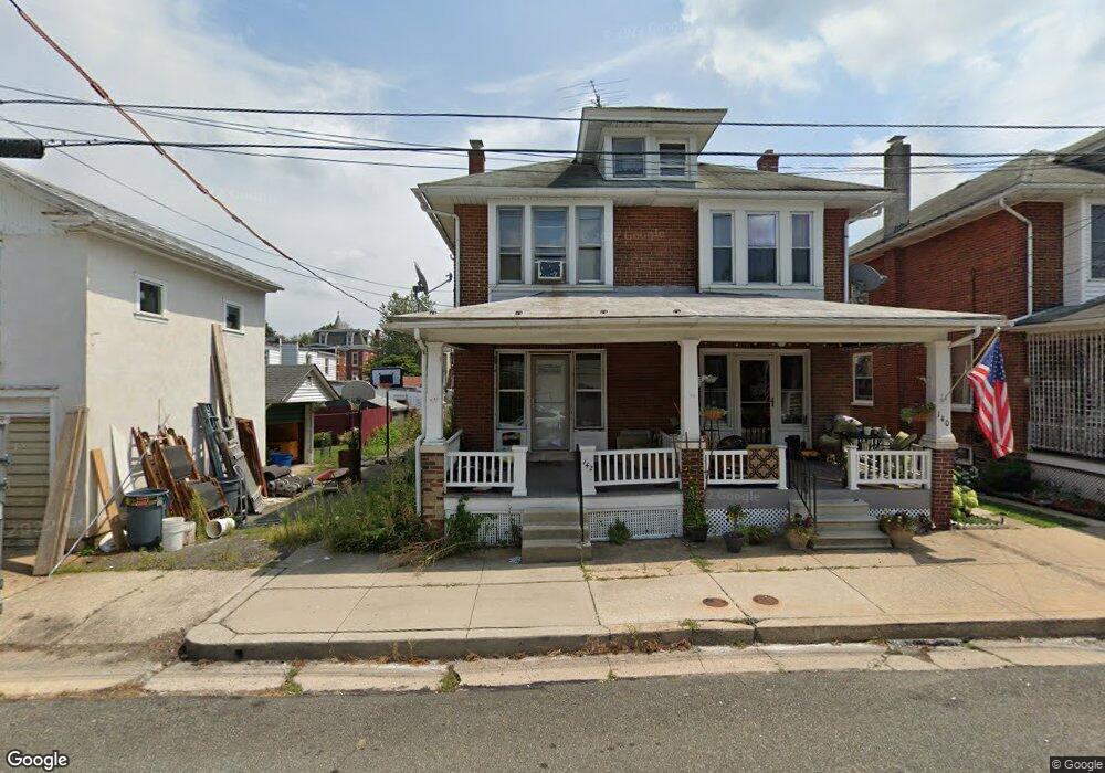
142 N Walnut St Boyertown, PA 19512
Estimated Value: $233,000 - $264,000
3
Beds
2
Baths
1,381
Sq Ft
$179/Sq Ft
Est. Value
About This Home
This home is located at 142 N Walnut St, Boyertown, PA 19512 and is currently estimated at $246,643, approximately $178 per square foot. 142 N Walnut St is a home located in Berks County with nearby schools including Boyertown Area Senior High School and Brookeside Montessori School.
Ownership History
Date
Name
Owned For
Owner Type
Purchase Details
Closed on
Apr 24, 2020
Sold by
Ds Group Llc
Bought by
Lias Timothy
Current Estimated Value
Home Financials for this Owner
Home Financials are based on the most recent Mortgage that was taken out on this home.
Original Mortgage
$160,050
Outstanding Balance
$141,516
Interest Rate
3.3%
Mortgage Type
New Conventional
Estimated Equity
$105,127
Purchase Details
Closed on
Jan 23, 2020
Sold by
Mccarthy Philip and Mccarthy Stephenie
Bought by
Ds Group Llc
Purchase Details
Closed on
Nov 21, 2008
Sold by
Bechtel Gloria F
Bought by
Mccarthy Philip S and Mccarthy Stephanie
Home Financials for this Owner
Home Financials are based on the most recent Mortgage that was taken out on this home.
Original Mortgage
$154,063
Interest Rate
6.11%
Mortgage Type
FHA
Create a Home Valuation Report for This Property
The Home Valuation Report is an in-depth analysis detailing your home's value as well as a comparison with similar homes in the area
Home Values in the Area
Average Home Value in this Area
Purchase History
| Date | Buyer | Sale Price | Title Company |
|---|---|---|---|
| Lias Timothy | $165,000 | Sentry Abstract Company | |
| Ds Group Llc | $102,000 | None Available | |
| Mccarthy Philip S | $154,900 | First American Title Ins Co |
Source: Public Records
Mortgage History
| Date | Status | Borrower | Loan Amount |
|---|---|---|---|
| Open | Lias Timothy | $160,050 | |
| Previous Owner | Mccarthy Philip S | $154,063 |
Source: Public Records
Tax History Compared to Growth
Tax History
| Year | Tax Paid | Tax Assessment Tax Assessment Total Assessment is a certain percentage of the fair market value that is determined by local assessors to be the total taxable value of land and additions on the property. | Land | Improvement |
|---|---|---|---|---|
| 2025 | $1,691 | $87,600 | $35,600 | $52,000 |
| 2024 | $4,222 | $87,600 | $35,600 | $52,000 |
| 2023 | $4,048 | $87,600 | $35,600 | $52,000 |
| 2022 | $3,933 | $87,600 | $35,600 | $52,000 |
| 2021 | $3,797 | $87,600 | $35,600 | $52,000 |
| 2020 | $3,708 | $87,600 | $35,600 | $52,000 |
| 2019 | $3,567 | $87,600 | $35,600 | $52,000 |
| 2018 | $3,418 | $87,600 | $35,600 | $52,000 |
| 2017 | $3,310 | $87,600 | $35,600 | $52,000 |
| 2016 | $1,117 | $87,600 | $35,600 | $52,000 |
| 2015 | $1,117 | $87,600 | $35,600 | $52,000 |
| 2014 | $1,074 | $87,600 | $35,600 | $52,000 |
Source: Public Records
Map
Nearby Homes
- 119 Schaeffer St
- 0 W Philadelphia Ave
- 0 Red Shale Dr Unit PABK2066086
- 231 N Franklin St
- 100 College St
- 151 S Reading Ave
- 626 N Reading Ave
- 332 S Reading Ave
- 622 Rhoads Ave
- 201 Henry Ave
- 1028 Weisstown Rd
- Norris Plan at Spring Garden Meadows
- 241 Sweinhart Rd
- 34 Chestnut Ln
- 910 Clover Ln
- 280 Indian Ln
- 60 Foxwood Dr
- 0 Spring Garden Dr
- 160-A Spring Garden Dr
- 23 Foxwood Dr