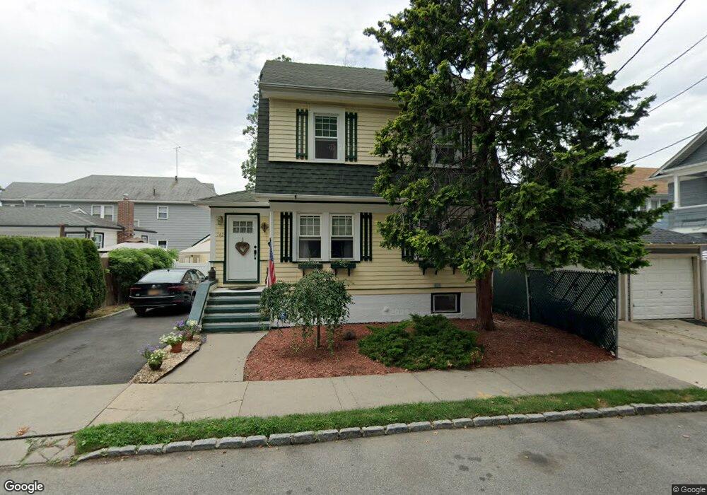
142 Neal Dow Ave Staten Island, NY 10314
Westerleigh NeighborhoodEstimated Value: $608,853 - $793,000
--
Bed
--
Bath
1,092
Sq Ft
$665/Sq Ft
Est. Value
About This Home
This home is located at 142 Neal Dow Ave, Staten Island, NY 10314 and is currently estimated at $726,213, approximately $665 per square foot. 142 Neal Dow Ave is a home located in Richmond County with nearby schools including P.S. 30 Westerleigh, I.S. 51 Edwin Markham, and Port Richmond High School.
Ownership History
Date
Name
Owned For
Owner Type
Purchase Details
Closed on
Dec 20, 2022
Sold by
Benevento Paulette J
Bought by
Benevento Paulette J and Benevento Zachary L
Current Estimated Value
Purchase Details
Closed on
Oct 25, 2004
Sold by
Benevento John and Benevento Doreen F
Bought by
Benevento Paulette J
Purchase Details
Closed on
Mar 31, 1998
Sold by
Hickey Helen V
Bought by
Benevento John and Benevento Doreen F
Create a Home Valuation Report for This Property
The Home Valuation Report is an in-depth analysis detailing your home's value as well as a comparison with similar homes in the area
Home Values in the Area
Average Home Value in this Area
Purchase History
| Date | Buyer | Sale Price | Title Company |
|---|---|---|---|
| Benevento Paulette J | -- | -- | |
| Benevento Paulette J | -- | -- | |
| Benevento John | $150,000 | -- |
Source: Public Records
Tax History Compared to Growth
Tax History
| Year | Tax Paid | Tax Assessment Tax Assessment Total Assessment is a certain percentage of the fair market value that is determined by local assessors to be the total taxable value of land and additions on the property. | Land | Improvement |
|---|---|---|---|---|
| 2025 | $6,433 | $37,440 | $12,210 | $25,230 |
| 2024 | $6,445 | $35,700 | $12,416 | $23,284 |
| 2023 | $6,120 | $31,536 | $10,130 | $21,406 |
| 2022 | $5,836 | $37,080 | $13,260 | $23,820 |
| 2021 | $6,105 | $33,240 | $13,260 | $19,980 |
| 2020 | $5,785 | $32,040 | $13,260 | $18,780 |
| 2019 | $5,534 | $30,060 | $13,260 | $16,800 |
| 2018 | $5,060 | $26,280 | $12,653 | $13,627 |
| 2017 | $4,911 | $25,560 | $13,260 | $12,300 |
| 2016 | $4,763 | $25,376 | $12,892 | $12,484 |
| 2015 | $4,150 | $23,940 | $14,100 | $9,840 |
| 2014 | $4,150 | $23,214 | $13,537 | $9,677 |
Source: Public Records
Map
Nearby Homes
- 116 Bidwell Ave
- 184 Dickie Ave
- 151 Clinton B Fisk Ave
- 153 Clinton B Fisk Ave
- 262 Maine Ave
- 159 North Ave
- 32 Dickie Ave
- 349 College Ave
- 36 Shaw Place
- 60 North Ave
- 325 College Ave
- 615 Jewett Ave
- 40 North Ave
- 78 Burnside Ave
- 304 Kingsley Ave
- 279 Saint John Ave
- 751 Jewett Ave Unit 17
- 751 Jewett Ave
- 282 Willard Ave
- 75 Muller Ave
- 145 Garrison Ave
- 141 Garrison Ave
- 151 Garrison Ave
- 340 Maine Ave
- 344 Maine Ave
- 153 Garrison Ave
- 348 Maine Ave
- 352 Maine Ave
- 157 Garrison Ave
- 356 Maine Ave
- 152 Garrison Ave
- 159 Garrison Ave
- 144 Garrison Ave
- 360 Maine Ave
- 158 Neal Dow Ave
- 156 Garrison Ave Unit 158
- 156-158 Garrison Ave
- 161 Garrison Ave
- 347 Maine Ave Unit 1
- 347 Maine Ave Unit 2