Estimated Value: $209,000 - $238,000
3
Beds
2
Baths
1,402
Sq Ft
$159/Sq Ft
Est. Value
About This Home
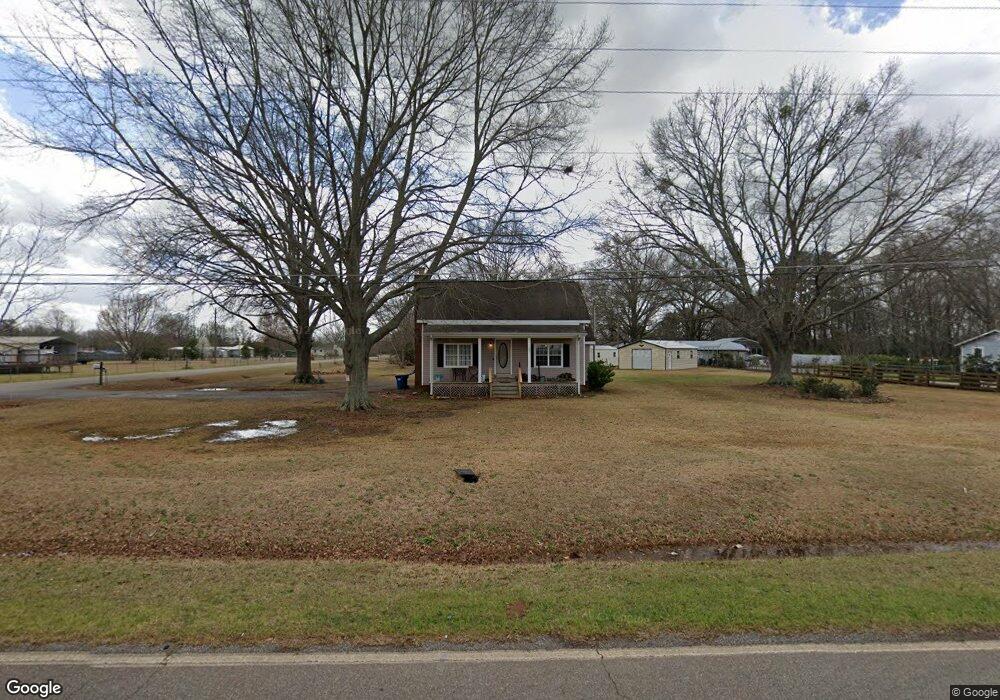
This home is located at 142 Todd Rd, Perry, GA 31069 and is currently estimated at $222,762, approximately $158 per square foot. 142 Todd Rd is a home located in Houston County with nearby schools including Langston Road Elementary School, Mossy Creek Middle School, and Perry High School.
Ownership History
Date
Name
Owned For
Owner Type
Purchase Details
Closed on
Feb 18, 2004
Sold by
Snell Darrell G
Bought by
Snell Diane D
Current Estimated Value
Purchase Details
Closed on
Dec 1, 1993
Bought by
Snell Darrell G and Snell Diane D
Purchase Details
Closed on
Jul 2, 1993
Sold by
Bellflower Diane D
Bought by
Snell Darrell G and Snell Diane D
Purchase Details
Closed on
Dec 18, 1989
Sold by
Bellflower Cleveland Jr
Bought by
Bellflower Diane D
Purchase Details
Closed on
Jun 24, 1983
Bought by
Bellflower Cleveland Jr & Diane D
Create a Home Valuation Report for This Property
The Home Valuation Report is an in-depth analysis detailing your home's value as well as a comparison with similar homes in the area
Home Values in the Area
Average Home Value in this Area
Purchase History
| Date | Buyer | Sale Price | Title Company |
|---|---|---|---|
| Snell Diane D | -- | -- | |
| Snell Darrell G | -- | -- | |
| Snell Darrell G | -- | -- | |
| Bellflower Diane D | -- | -- | |
| Bellflower Cleveland Jr & Diane D | -- | -- |
Source: Public Records
Tax History
| Year | Tax Paid | Tax Assessment Tax Assessment Total Assessment is a certain percentage of the fair market value that is determined by local assessors to be the total taxable value of land and additions on the property. | Land | Improvement |
|---|---|---|---|---|
| 2025 | $1,337 | $61,200 | $14,320 | $46,880 |
| 2024 | $1,404 | $58,680 | $14,320 | $44,360 |
| 2023 | $1,232 | $50,960 | $14,200 | $36,760 |
| 2022 | $1,183 | $48,960 | $14,200 | $34,760 |
| 2021 | $918 | $37,800 | $6,880 | $30,920 |
| 2020 | $820 | $33,600 | $6,440 | $27,160 |
| 2019 | $820 | $33,600 | $6,440 | $27,160 |
| 2018 | $820 | $33,600 | $6,440 | $27,160 |
| 2017 | $821 | $33,600 | $6,440 | $27,160 |
| 2016 | $824 | $33,600 | $6,440 | $27,160 |
| 2015 | $824 | $33,600 | $6,440 | $27,160 |
| 2014 | -- | $33,600 | $6,440 | $27,160 |
| 2013 | -- | $33,600 | $6,440 | $27,160 |
Source: Public Records
Map
Nearby Homes
- 309 Bermuda Ridge
- 108 Chimney Rock Rd
- 105 Senimor Ct
- 501 Longhorn Trail
- 204 Greylock Dr
- 124 Lake Lillian Dr
- 103 Denali Dr
- 502 Arons Ct
- 150 MacK Thompson Rd
- 0 MacK Thompson Rd Unit 253661
- 149 MacK Thompson Road Common
- 127 Bramblewood Ln
- 117 Bramblewood Ln
- 119 Bramblewood Ln
- 115 Bramblewood Ln
- 0 Hwy 41 & Langston Rd Unit M170042
- 0 Langston Rd Unit 16828609
- 111 Breakwater Way
- 118 Bramblewood Way
- 2327 Us Hwy 41
Your Personal Tour Guide
Ask me questions while you tour the home.