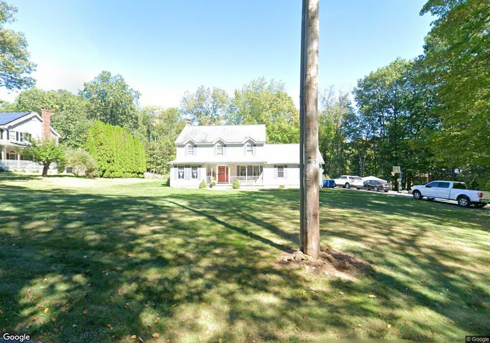
1420 Morgan Rd West Springfield, MA 01089
Estimated Value: $503,000 - $710,000
4
Beds
3
Baths
2,004
Sq Ft
$281/Sq Ft
Est. Value
About This Home
This home is located at 1420 Morgan Rd, West Springfield, MA 01089 and is currently estimated at $562,286, approximately $280 per square foot. 1420 Morgan Rd is a home located in Hampden County with nearby schools including Hampden Charter School of Science West and St Thomas The Apostle School.
Ownership History
Date
Name
Owned For
Owner Type
Purchase Details
Closed on
Aug 5, 2011
Sold by
Connor 3Rd Gerard P and Connor Ann Ma
Bought by
Balboni Matthew A and Balboni Laurie A
Current Estimated Value
Home Financials for this Owner
Home Financials are based on the most recent Mortgage that was taken out on this home.
Original Mortgage
$262,800
Outstanding Balance
$180,145
Interest Rate
4.51%
Mortgage Type
Purchase Money Mortgage
Estimated Equity
$382,141
Purchase Details
Closed on
Aug 25, 2009
Sold by
Connor Gerard Paul and Connor Ann Marie A
Bought by
Couture Mario B and Couture Denyse A
Create a Home Valuation Report for This Property
The Home Valuation Report is an in-depth analysis detailing your home's value as well as a comparison with similar homes in the area
Home Values in the Area
Average Home Value in this Area
Purchase History
| Date | Buyer | Sale Price | Title Company |
|---|---|---|---|
| Balboni Matthew A | $328,500 | -- | |
| Couture Mario B | -- | -- |
Source: Public Records
Mortgage History
| Date | Status | Borrower | Loan Amount |
|---|---|---|---|
| Open | Balboni Matthew A | $262,800 |
Source: Public Records
Tax History Compared to Growth
Tax History
| Year | Tax Paid | Tax Assessment Tax Assessment Total Assessment is a certain percentage of the fair market value that is determined by local assessors to be the total taxable value of land and additions on the property. | Land | Improvement |
|---|---|---|---|---|
| 2025 | $6,518 | $438,300 | $146,200 | $292,100 |
| 2024 | $6,164 | $416,200 | $146,200 | $270,000 |
| 2023 | $6,039 | $388,600 | $153,400 | $235,200 |
| 2022 | $5,519 | $350,200 | $139,600 | $210,600 |
| 2021 | $5,596 | $331,100 | $133,000 | $198,100 |
| 2020 | $5,615 | $330,500 | $133,000 | $197,500 |
| 2019 | $5,605 | $330,500 | $133,000 | $197,500 |
| 2018 | $5,635 | $330,500 | $133,000 | $197,500 |
| 2017 | $5,635 | $330,500 | $133,000 | $197,500 |
| 2016 | $5,668 | $333,600 | $127,900 | $205,700 |
| 2015 | $5,561 | $327,300 | $125,500 | $201,800 |
| 2014 | $1,352 | $327,300 | $125,500 | $201,800 |
Source: Public Records
Map
Nearby Homes
- 86 Birnie Ave
- 34 High Meadow Dr
- 11 Annie's Way
- 59 Clayton Dr
- 283 Forest Glen
- 50 Overlook Dr
- 31 Stone Path Ln
- 39 Bonnie Brae Dr
- 514 Dewey St
- 80 Brush Hill Ave Unit 28
- 80 Brush Hill Ave Unit 32
- 36 Shady Brook
- 846 E Mountain Rd
- 89-111 Whitney Ave
- 32 Windpath E
- 17 Laurence Dr
- 287 Whitney Ave
- 81 Laurence Dr
- lot b Homestead Ave
- 260 Wolcott Ave
- 1436 Morgan Rd
- 1410 Morgan Rd
- 1452 Morgan Rd
- 1400 Morgan Rd
- 1466 Morgan Rd
- 1407 Morgan Rd
- 1362 Morgan Rd
- 1482 Morgan Rd
- 1359 Morgan Rd
- 1492 Morgan Rd
- 1360 Morgan Rd
- 1510 Morgan Rd
- 1500 Morgan Rd
- 1520 Morgan Rd
- 1350 Morgan Rd
- 1413 Morgan Rd
- 1528 Morgan Rd
- 1320 Morgan Rd
- 1321 Morgan Rd
- 150 Hannoush Dr