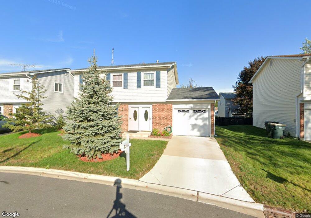
1420 Sturbridge Ct Hoffman Estates, IL 60192
South Ridge NeighborhoodEstimated Value: $373,000 - $447,000
3
Beds
2
Baths
1,606
Sq Ft
$257/Sq Ft
Est. Value
About This Home
This home is located at 1420 Sturbridge Ct, Hoffman Estates, IL 60192 and is currently estimated at $412,738, approximately $256 per square foot. 1420 Sturbridge Ct is a home located in Cook County with nearby schools including Thomas Jefferson Elementary School, Frank C. Whiteley Elementary School, and William Fremd High School.
Ownership History
Date
Name
Owned For
Owner Type
Purchase Details
Closed on
Nov 19, 2018
Sold by
Klimchenko Lesya
Bought by
Klimchenko Lesya and Lesya Klimchenko Living Trust
Current Estimated Value
Purchase Details
Closed on
Sep 23, 2009
Sold by
Klimchenko Lesya
Bought by
Klimchenko Lesya
Purchase Details
Closed on
Jul 10, 1997
Sold by
Kotorynsky Michael
Bought by
Kotorynsky Michael and Michael Kotorynsky Trust
Purchase Details
Closed on
Jul 28, 1994
Bought by
Kotorynsky Michael and Kotorynsky Helen
Create a Home Valuation Report for This Property
The Home Valuation Report is an in-depth analysis detailing your home's value as well as a comparison with similar homes in the area
Home Values in the Area
Average Home Value in this Area
Purchase History
| Date | Buyer | Sale Price | Title Company |
|---|---|---|---|
| Klimchenko Lesya | -- | Attorney | |
| Klimchenko Lesya | -- | Atg | |
| Kotorynsky Michael | -- | -- | |
| Kotorynsky Michael | $142,000 | -- |
Source: Public Records
Tax History
| Year | Tax Paid | Tax Assessment Tax Assessment Total Assessment is a certain percentage of the fair market value that is determined by local assessors to be the total taxable value of land and additions on the property. | Land | Improvement |
|---|---|---|---|---|
| 2025 | $7,211 | $35,000 | $4,424 | $30,576 |
| 2024 | $7,211 | $26,839 | $3,792 | $23,047 |
| 2023 | $6,939 | $26,839 | $3,792 | $23,047 |
| 2022 | $6,939 | $26,839 | $3,792 | $23,047 |
| 2021 | $6,947 | $24,075 | $2,633 | $21,442 |
| 2020 | $6,868 | $24,075 | $2,633 | $21,442 |
| 2019 | $6,799 | $26,691 | $2,633 | $24,058 |
| 2018 | $6,431 | $23,734 | $2,422 | $21,312 |
| 2017 | $6,330 | $23,734 | $2,422 | $21,312 |
| 2016 | $6,128 | $23,734 | $2,422 | $21,312 |
| 2015 | $6,136 | $22,366 | $2,211 | $20,155 |
| 2014 | $6,037 | $22,366 | $2,211 | $20,155 |
| 2013 | $5,866 | $22,366 | $2,211 | $20,155 |
Source: Public Records
Map
Nearby Homes
- 1478 W Sapphire Dr
- 4480 Thornbark Dr
- 1690 Cape Breton Ct
- 1280 Clover Ln
- 4100 N Victoria Dr
- 1213 Silver Pine Dr
- 3881 Bordeaux Dr
- 3830 Anjou Ln
- 4950 Tarrington Dr
- 4990 Rochester Dr
- 61 E Rd
- 61 E Rd
- 61 E Palatine #4 Rd
- 5190 Chambers Dr
- 61 E Palatine Rd
- 1030 Ridgeview Dr
- 2072 Palatine Rd
- 2204 Shetland Rd
- 1120 Ashley Ln
- 1115 Ashley Ln
- 1430 Sturbridge Ct
- 1425 Sturbridge Ct
- 4370 N Stone Harbor Dr
- 4360 N Stone Harbor Dr
- 4380 N Stone Harbor Dr
- 1440 Sturbridge Ct
- 1435 Sturbridge Ct
- 4350 N Stone Harbor Dr
- 1425 Westbury Dr
- 1450 Sturbridge Ct
- 4390 N Stone Harbor Dr
- 1435 Westbury Dr
- 1410 W Stone Harbor Dr
- 1445 Sturbridge Ct
- 1420 W Stone Harbor Dr
- 1455 Sturbridge Ct
- 1445 Westbury Dr
- 1390 Gloucester Ct
- 1395 Gloucester Ct
- 1430 W Stone Harbor Dr
Your Personal Tour Guide
Ask me questions while you tour the home.