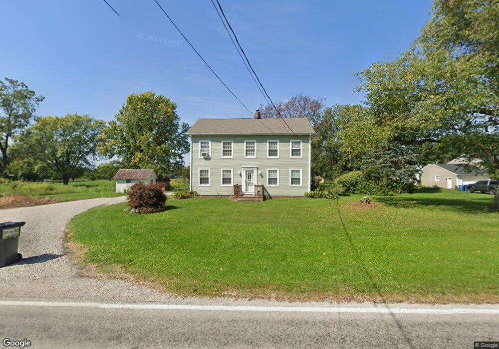
14213 Mason Rd Vermilion, OH 44089
Estimated Value: $274,675 - $338,000
3
Beds
2
Baths
2,016
Sq Ft
$150/Sq Ft
Est. Value
About This Home
This home is located at 14213 Mason Rd, Vermilion, OH 44089 and is currently estimated at $302,419, approximately $150 per square foot. 14213 Mason Rd is a home located in Erie County with nearby schools including Vermilion Elementary School, Sailorway Middle School, and Vermilion High School.
Ownership History
Date
Name
Owned For
Owner Type
Purchase Details
Closed on
Nov 9, 2021
Sold by
Bongalis Jeffrey D
Bought by
Manning Mark M
Current Estimated Value
Home Financials for this Owner
Home Financials are based on the most recent Mortgage that was taken out on this home.
Original Mortgage
$5,301
Outstanding Balance
$4,859
Interest Rate
3.01%
Mortgage Type
New Conventional
Estimated Equity
$297,560
Purchase Details
Closed on
Jan 7, 2000
Sold by
Farr James A
Bought by
Bongalis Jeffrey D
Purchase Details
Closed on
Sep 13, 1996
Sold by
Butcher Wyett M
Bought by
Farr James A and Farr Debra A
Home Financials for this Owner
Home Financials are based on the most recent Mortgage that was taken out on this home.
Original Mortgage
$108,000
Interest Rate
8.63%
Mortgage Type
New Conventional
Create a Home Valuation Report for This Property
The Home Valuation Report is an in-depth analysis detailing your home's value as well as a comparison with similar homes in the area
Home Values in the Area
Average Home Value in this Area
Purchase History
| Date | Buyer | Sale Price | Title Company |
|---|---|---|---|
| Manning Mark M | $230,000 | None Available | |
| Bongalis Jeffrey D | $149,000 | -- | |
| Farr James A | $140,000 | -- |
Source: Public Records
Mortgage History
| Date | Status | Borrower | Loan Amount |
|---|---|---|---|
| Open | Manning Mark M | $5,301 | |
| Previous Owner | Farr James A | $108,000 | |
| Closed | Bongalis Jeffrey D | -- |
Source: Public Records
Tax History Compared to Growth
Tax History
| Year | Tax Paid | Tax Assessment Tax Assessment Total Assessment is a certain percentage of the fair market value that is determined by local assessors to be the total taxable value of land and additions on the property. | Land | Improvement |
|---|---|---|---|---|
| 2024 | $2,111 | $56,941 | $13,160 | $43,781 |
| 2023 | $2,111 | $45,010 | $10,388 | $34,622 |
| 2022 | $1,850 | $45,010 | $10,388 | $34,622 |
| 2021 | $1,877 | $45,010 | $10,390 | $34,620 |
| 2020 | $1,747 | $40,830 | $10,390 | $30,440 |
| 2019 | $1,819 | $40,830 | $10,390 | $30,440 |
| 2018 | $1,821 | $40,830 | $10,390 | $30,440 |
| 2017 | $1,679 | $36,520 | $12,120 | $24,400 |
| 2016 | $1,668 | $36,520 | $12,120 | $24,400 |
| 2015 | $1,643 | $36,520 | $12,120 | $24,400 |
| 2014 | $1,657 | $36,520 | $12,120 | $24,400 |
| 2013 | $1,634 | $36,520 | $12,120 | $24,400 |
Source: Public Records
Map
Nearby Homes
- 14307 Mason Rd
- 13917 Mason Rd
- 9220 Cherry Rd
- V/L Darrow Rd
- 9708 Harrison Rd
- 15617 Sperry Rd
- 13612 Thompson Rd
- 9719 Angling Rd
- 3102 Ohio 60
- 12214 Thompson Rd
- 9113 Dean Rd
- 0 Darrow Rd Unit 5130066
- 0 Darrow Rd Unit 5130064
- 52808 N Ridge Rd
- 14611 Ohio 113
- 13514 State Route 113
- 7218 State Route 60
- 5860 Haber Rd
- 11815 W Lake Rd
- 1419 Sanford St
- 14301 Mason Rd
- 14203 Mason Rd
- 14208 Mason Rd
- 14116 Mason Rd
- 14212 Mason Rd
- 14313 Mason Rd
- 14115 Mason Rd
- 14308 Mason Rd
- 14112 Mason Rd
- 8303 Cemetery Rd
- 14120 Mason Rd
- 14220 Mason Rd
- 14303 Mason Rd
- 14103 Mason Rd
- 14106 Mason Rd
- 8209 Cemetery Rd
- 14416 Mason Rd
- 14015 Mason Rd
- 8203 Cemetery Rd
- 14014 Mason Rd