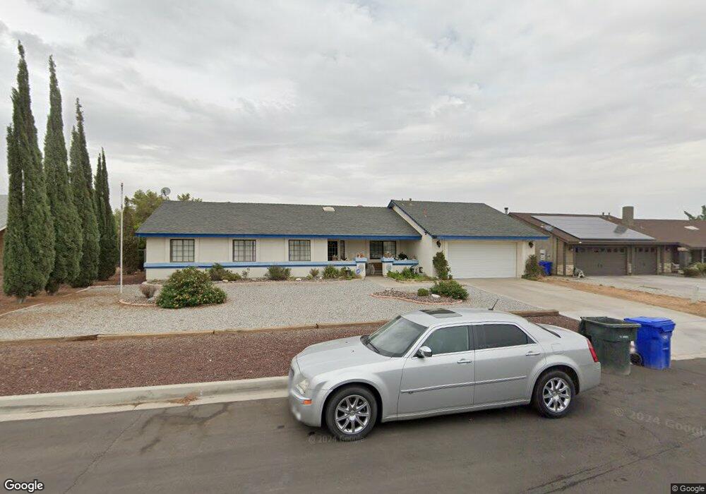
14236 Fort Apache Ct Victorville, CA 92392
Estimated Value: $389,105 - $418,000
4
Beds
2
Baths
1,560
Sq Ft
$259/Sq Ft
Est. Value
About This Home
This home is located at 14236 Fort Apache Ct, Victorville, CA 92392 and is currently estimated at $404,276, approximately $259 per square foot. 14236 Fort Apache Ct is a home located in San Bernardino County with nearby schools including Liberty Elementary School, Park View Elementary School, and Imogene Garner Hook Junior High School.
Ownership History
Date
Name
Owned For
Owner Type
Purchase Details
Closed on
Dec 20, 2021
Sold by
Johnson Arlene T
Bought by
Arlene Tingig Johnson Family Trust
Current Estimated Value
Purchase Details
Closed on
Feb 1, 2003
Sold by
Johnson Richard Allen
Bought by
Johnson Richard A and Johnson Arlene T
Home Financials for this Owner
Home Financials are based on the most recent Mortgage that was taken out on this home.
Original Mortgage
$97,000
Interest Rate
5.6%
Purchase Details
Closed on
Jun 13, 1997
Sold by
Shier Gary A and Shier Janet M
Bought by
Johnson Richard Allan
Home Financials for this Owner
Home Financials are based on the most recent Mortgage that was taken out on this home.
Original Mortgage
$82,829
Interest Rate
7.83%
Mortgage Type
FHA
Create a Home Valuation Report for This Property
The Home Valuation Report is an in-depth analysis detailing your home's value as well as a comparison with similar homes in the area
Home Values in the Area
Average Home Value in this Area
Purchase History
| Date | Buyer | Sale Price | Title Company |
|---|---|---|---|
| Arlene Tingig Johnson Family Trust | -- | None Listed On Document | |
| Johnson Richard A | -- | American | |
| Johnson Richard Allan | $83,000 | First American Title Ins Co |
Source: Public Records
Mortgage History
| Date | Status | Borrower | Loan Amount |
|---|---|---|---|
| Previous Owner | Johnson Richard A | $97,000 | |
| Previous Owner | Johnson Richard Allan | $82,829 |
Source: Public Records
Tax History Compared to Growth
Tax History
| Year | Tax Paid | Tax Assessment Tax Assessment Total Assessment is a certain percentage of the fair market value that is determined by local assessors to be the total taxable value of land and additions on the property. | Land | Improvement |
|---|---|---|---|---|
| 2025 | $1,606 | $141,896 | $31,935 | $109,961 |
| 2024 | $1,606 | $139,114 | $31,309 | $107,805 |
| 2023 | $1,481 | $127,385 | $30,694 | $96,691 |
| 2022 | $1,454 | $124,887 | $30,092 | $94,795 |
| 2021 | $1,425 | $122,438 | $29,502 | $92,936 |
| 2020 | $1,399 | $121,182 | $29,199 | $91,983 |
| 2019 | $1,374 | $118,805 | $28,626 | $90,179 |
| 2018 | $1,461 | $116,476 | $28,065 | $88,411 |
| 2017 | $1,430 | $114,192 | $27,515 | $86,677 |
| 2016 | $1,399 | $111,952 | $26,975 | $84,977 |
| 2015 | $1,349 | $110,271 | $26,570 | $83,701 |
| 2014 | $1,322 | $108,111 | $26,050 | $82,061 |
Source: Public Records
Map
Nearby Homes
- 12610 Alta Mar Way
- 14133 Pacoima Cir
- 14230 Hillsborough Dr
- 14390 Northstar Ave
- 12441 Petaluma Rd
- 12761 Paso Robles Dr
- 12471 Pacoima Rd
- 14389 Las Flores Dr
- 14200 La Mirada St
- 12867 Banyon Tree Ln
- 14535 Owens River Rd
- 13847 Galaxy Way
- 12668 Galaxy St
- 14583 Owens River Rd
- 12977 Dusty Rd
- 14195 Whispering Sands Dr
- 12452 Mount Baldy Dr
- 12831 Stage Coach Dr
- 12446 Mount Baldy Dr
- 12941 Bullet Ave
- 14224 Fort Apache Ct
- 14250 Fort Apache Ct
- 12614 Petaluma Rd
- 14210 Fort Apache Ct
- 12628 Petaluma Rd
- 14189 Deer Trail Ct
- 14198 Fort Apache Ct
- 14235 Fort Apache Ct
- 14249 Fort Apache Ct
- 14223 Fort Apache Ct
- 14197 Deer Trail Ct
- 12591 Petaluma Rd
- 12605 Petaluma Rd
- 12577 Petaluma Rd
- 14211 Fort Apache Ct
- 12617 Petaluma Rd
- 12642 Petaluma Rd
- 12565 Petaluma Rd
- 14197 Fort Apache Ct
- 14183 Deer Trail Ct