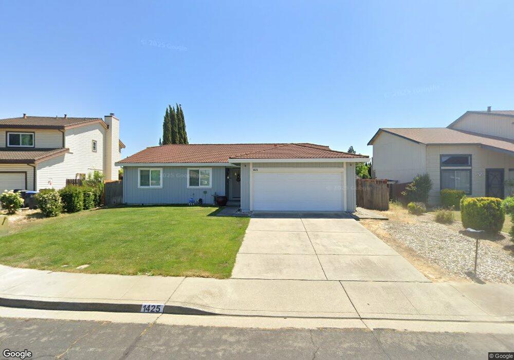
1425 Monitor Ave Suisun City, CA 94585
Estimated Value: $516,000 - $582,000
3
Beds
2
Baths
1,492
Sq Ft
$364/Sq Ft
Est. Value
About This Home
This home is located at 1425 Monitor Ave, Suisun City, CA 94585 and is currently estimated at $542,897, approximately $363 per square foot. 1425 Monitor Ave is a home located in Solano County with nearby schools including Dan O. Root Elementary School, Crystal Middle School, and Armijo High School.
Ownership History
Date
Name
Owned For
Owner Type
Purchase Details
Closed on
Mar 8, 2022
Sold by
Valarie Baker
Bought by
Valarie Baker Revocable Trust
Current Estimated Value
Purchase Details
Closed on
Oct 30, 2012
Sold by
Davis Margaret A
Bought by
Baker Valarie
Home Financials for this Owner
Home Financials are based on the most recent Mortgage that was taken out on this home.
Original Mortgage
$161,029
Interest Rate
3.5%
Mortgage Type
FHA
Create a Home Valuation Report for This Property
The Home Valuation Report is an in-depth analysis detailing your home's value as well as a comparison with similar homes in the area
Home Values in the Area
Average Home Value in this Area
Purchase History
| Date | Buyer | Sale Price | Title Company |
|---|---|---|---|
| Valarie Baker Revocable Trust | -- | Martin Dezanie A | |
| Baker Valarie | $164,000 | Fidelity National Title Co |
Source: Public Records
Mortgage History
| Date | Status | Borrower | Loan Amount |
|---|---|---|---|
| Previous Owner | Baker Valarie | $161,029 |
Source: Public Records
Tax History Compared to Growth
Tax History
| Year | Tax Paid | Tax Assessment Tax Assessment Total Assessment is a certain percentage of the fair market value that is determined by local assessors to be the total taxable value of land and additions on the property. | Land | Improvement |
|---|---|---|---|---|
| 2025 | $2,291 | $201,944 | $61,567 | $140,377 |
| 2024 | $2,291 | $197,985 | $60,360 | $137,625 |
| 2023 | $2,221 | $194,104 | $59,177 | $134,927 |
| 2022 | $2,192 | $190,299 | $58,017 | $132,282 |
| 2021 | $2,169 | $186,569 | $56,880 | $129,689 |
| 2020 | $2,119 | $184,657 | $56,297 | $128,360 |
| 2019 | $2,065 | $181,038 | $55,194 | $125,844 |
| 2018 | $2,145 | $177,489 | $54,112 | $123,377 |
| 2017 | $2,050 | $174,009 | $53,051 | $120,958 |
| 2016 | $2,166 | $170,598 | $52,011 | $118,587 |
| 2015 | $2,189 | $168,036 | $51,230 | $116,806 |
| 2014 | $2,174 | $164,745 | $50,227 | $114,518 |
Source: Public Records
Map
Nearby Homes
- 1201 Deanza Ct
- 1504 El Morro Ln
- 1416 Prospect Way
- 1411 Klamath Dr
- 1415 Pelican Way
- 610 Placer Ln
- 819 Bluejay Dr
- 1109 Canary Dr
- 1651 Little Rock Cir
- 1309 Hall Ln
- 607 Crested Dr
- 1756 Keesler Cir
- 1413 Spence Ct
- 1280 Mayfield Cir
- 330 Engell Ct
- 301 Childs Ct
- 808 Pochard Way
- 616 Emperor Dr
- 906 Trumpeter Ct
- 412 Craven Dr
- 1423 Monitor Ave
- 1427 Monitor Ave
- 1421 Monitor Ave
- 1429 Monitor Ave
- 1426 Monitor Ave
- 1404 Ebbetts Ct
- 1424 Monitor Ave
- 1424 Monitor Ave
- 1431 Monitor Ave
- 1406 Ebbetts Ct
- 1402 Ebbetts Ct
- 1423 Pintail Dr Unit 9
- 1433 Monitor Ave
- 1434 Monitor Ave
- 1421 Pintail Dr
- 805 Whitney Ave
- 800 Whitney Ave
- 1407 Ebbetts Ct
- 802 Whitney Ave