Estimated Value: $240,000 - $300,000
3
Beds
3
Baths
1,744
Sq Ft
$151/Sq Ft
Est. Value
About This Home
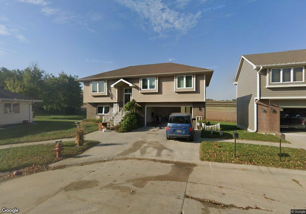
This home is located at 1426 Jones Cir, Logan, IA 51546 and is currently estimated at $262,689, approximately $150 per square foot. 1426 Jones Cir is a home located in Harrison County with nearby schools including Logan-Magnolia Elementary School and Logan-Magnolia Junior/Senior High School.
Ownership History
Date
Name
Owned For
Owner Type
Purchase Details
Closed on
May 24, 2022
Sold by
Empire Wholesale Llc
Bought by
Doman Daryl D and Deman Hazel
Current Estimated Value
Purchase Details
Closed on
Mar 2, 2022
Sold by
United States Of America
Bought by
Empire Wholesale Llc
Purchase Details
Closed on
Mar 22, 2019
Sold by
Usda
Bought by
Usda
Purchase Details
Closed on
Aug 23, 2012
Sold by
Jones Kenneth W and Jones Carla J
Bought by
Arndt Austin K and Arndt Linday M
Home Financials for this Owner
Home Financials are based on the most recent Mortgage that was taken out on this home.
Original Mortgage
$123,750
Interest Rate
3.54%
Mortgage Type
USDA
Purchase Details
Closed on
Sep 19, 2011
Sold by
Jones Kennith W and Jones Carla J
Bought by
Arndt Austin K and Arndt Lindsey M
Home Financials for this Owner
Home Financials are based on the most recent Mortgage that was taken out on this home.
Original Mortgage
$41,250
Interest Rate
4.4%
Mortgage Type
Purchase Money Mortgage
Create a Home Valuation Report for This Property
The Home Valuation Report is an in-depth analysis detailing your home's value as well as a comparison with similar homes in the area
Home Values in the Area
Average Home Value in this Area
Purchase History
| Date | Buyer | Sale Price | Title Company |
|---|---|---|---|
| Doman Daryl D | $195,000 | Blair Abstract Title | |
| Empire Wholesale Llc | $104,069 | Huizenga Law Firm Pc | |
| Usda | $155,689 | -- | |
| Arndt Austin K | $165,000 | None Available | |
| Arndt Austin K | $165,000 | None Available |
Source: Public Records
Mortgage History
| Date | Status | Borrower | Loan Amount |
|---|---|---|---|
| Previous Owner | Arndt Austin K | $123,750 | |
| Previous Owner | Arndt Austin K | $41,250 |
Source: Public Records
Tax History Compared to Growth
Tax History
| Year | Tax Paid | Tax Assessment Tax Assessment Total Assessment is a certain percentage of the fair market value that is determined by local assessors to be the total taxable value of land and additions on the property. | Land | Improvement |
|---|---|---|---|---|
| 2025 | $3,896 | $239,130 | $21,000 | $218,130 |
| 2024 | $3,896 | $221,680 | $21,000 | $200,680 |
| 2023 | $3,760 | $221,680 | $21,000 | $200,680 |
| 2022 | $3,252 | $166,799 | $21,000 | $145,799 |
| 2021 | $3,252 | $166,799 | $21,000 | $145,799 |
| 2020 | $2,968 | $159,119 | $21,000 | $138,119 |
| 2019 | $2,508 | $156,661 | $21,000 | $135,661 |
| 2018 | $2,553 | $133,686 | $0 | $0 |
| 2017 | $2,452 | $133,686 | $0 | $0 |
| 2016 | $2,570 | $133,686 | $0 | $0 |
| 2015 | $2,570 | $120,438 | $0 | $0 |
| 2014 | $2,246 | $120,438 | $0 | $0 |
Source: Public Records
Map
Nearby Homes
- 124 Glen Ave
- 1010 Skyline Dr
- 114 E 10th St
- Lot 18 Mulligan Trail
- 2144 Norton Ave
- LOT 27 Mulligan Trail
- 2484 280th St
- LOT 26 Lmvcc Estates
- 2464 Mulligan Trail
- LOT 20 Lmvcc Estates
- LOT 17 Lmvcc Estates
- Lot 17 Lmvcc Estates Trail
- LOT 15 Mulligan Trail
- 2853 Preston Place
- 0 Preston Place
- 0 Preston Place 2 Parcels
- LOT 45 Shadow Hill Estates
- Lot 45 & 45A Shadow Hill Estates
- 3131 U S 30
- LOT 30 Shadow Hill Estates
- LOT 7 Jones Cir
- LOT 8 Jones Cir
- LOT 6 Jones Cir
- LOT 5 Jones Cir
- 1425 Jones Cir
- 1414 Jones Cir
- 1413 Jones Cir
- 1408 Jones Cir
- 1408 Jones Cir
- 1407 Jones Cir
- 1420 Jones Cir
- 1402 Jones Cir
- 1401 Jones Cir
- 2703 Highway 127
- 2707 Highway 127
- 1207 Industrial Dr
- 1200 N 2nd Ave
- 1200 N 2nd Ave
- 2748 Highway 127
- 2748 Highway 127