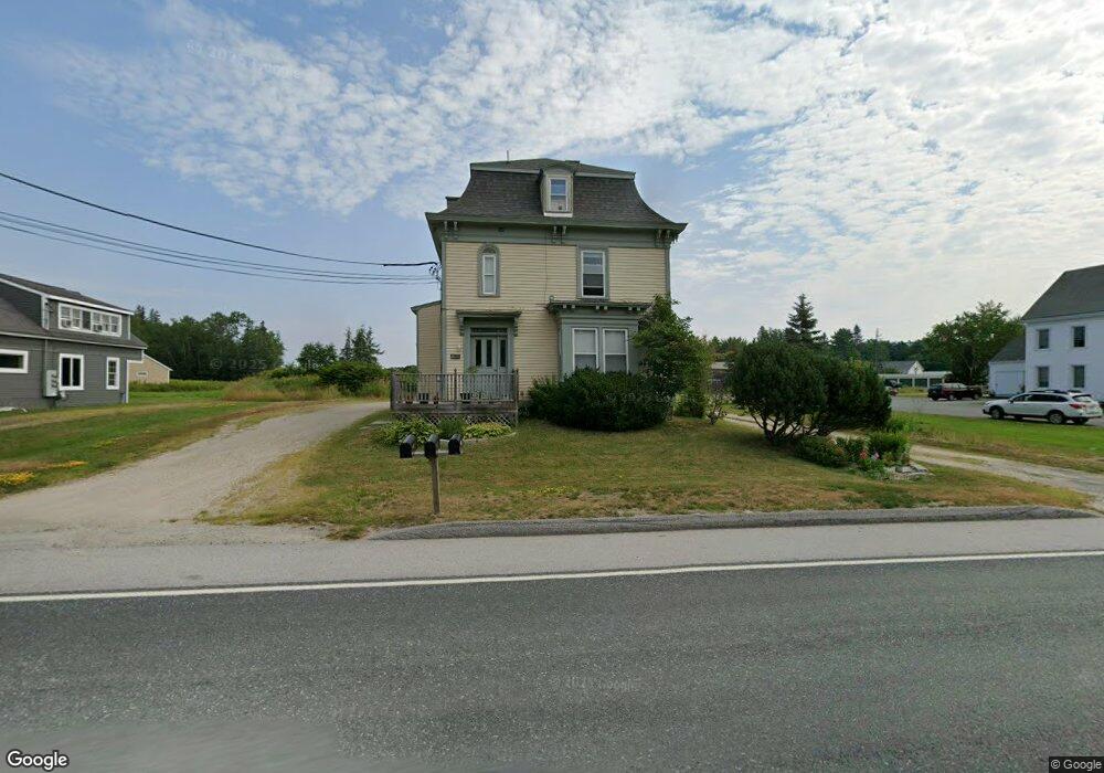
1428 U S Route One Hancock, ME 04640
Estimated Value: $412,000
Studio
--
Bath
--
Sq Ft
43,560
Sq Ft Lot
About This Home
This home is located at 1428 U S Route One, Hancock, ME 04640 and is currently estimated at $412,000. 1428 U S Route One is a home located in Hancock County with nearby schools including Sumner Memorial High School.
Ownership History
Date
Name
Owned For
Owner Type
Purchase Details
Closed on
Nov 12, 2019
Sold by
Parrot Edward G and Covert Christine J
Bought by
Simon Eli M
Current Estimated Value
Home Financials for this Owner
Home Financials are based on the most recent Mortgage that was taken out on this home.
Original Mortgage
$150,000
Outstanding Balance
$131,388
Interest Rate
3.6%
Mortgage Type
New Conventional
Estimated Equity
$280,612
Create a Home Valuation Report for This Property
The Home Valuation Report is an in-depth analysis detailing your home's value as well as a comparison with similar homes in the area
Home Values in the Area
Average Home Value in this Area
Purchase History
| Date | Buyer | Sale Price | Title Company |
|---|---|---|---|
| Simon Eli M | -- | -- | |
| Simon Eli M | -- | -- | |
| Simon Eli M | -- | -- |
Source: Public Records
Mortgage History
| Date | Status | Borrower | Loan Amount |
|---|---|---|---|
| Open | Simon Eli M | $150,000 | |
| Closed | Simon Eli M | $150,000 |
Source: Public Records
Tax History
| Year | Tax Paid | Tax Assessment Tax Assessment Total Assessment is a certain percentage of the fair market value that is determined by local assessors to be the total taxable value of land and additions on the property. | Land | Improvement |
|---|---|---|---|---|
| 2024 | $1,902 | $161,900 | $37,500 | $124,400 |
| 2023 | $1,700 | $161,900 | $37,500 | $124,400 |
| 2022 | $1,700 | $161,900 | $37,500 | $124,400 |
| 2021 | $1,781 | $161,900 | $37,500 | $124,400 |
| 2019 | $1,732 | $161,900 | $37,500 | $124,400 |
| 2018 | $1,781 | $161,900 | $37,500 | $124,400 |
| 2017 | $1,781 | $161,900 | $37,500 | $124,400 |
| 2016 | $1,781 | $161,900 | $37,500 | $124,400 |
| 2015 | $1,502 | $145,100 | $37,500 | $107,600 |
| 2014 | $1,451 | $145,100 | $37,500 | $107,600 |
| 2013 | $1,563 | $157,100 | $37,500 | $119,600 |
Source: Public Records
Map
Nearby Homes
- 32 Taunton Keep
- 136 Taunton Dr
- 10 Romeo Blvd
- 81 Old Route 1
- 1723 U S 1
- 350 Taunton Dr
- Lot #5 Leonia Rd
- Lot #2 Leonia Rd
- Lot #3 Leonia Rd
- Lot #4 Leonia Rd
- Lot #1 Leonia Rd
- Lot #6 Leonia Rd
- Lot #8 Leonia Rd
- Lot #9 Leonia Rd
- 6 Nob Hill Rd
- 1920 Us Highway 1
- 122 Cross Rd
- 141 Cross Rd
- 0 Solarina Ave Unit 1634527
- 103 Gull Rock Rd
- 1428 1
- 1428 Us Hwy 1
- 1428 Us Hwy 1
- 1424 Us Hwy 1
- 1434 Us Hwy 1
- 1421 Us Hwy 1
- 1427 Us Hwy 1
- 001 Point Rd
- Lot 1-1 Point Rd
- 1442 Us Hwy 1
- Lot 003 Point Rd
- 1417 Us Hwy 1
- 1408 Us Hwy 1
- 0 Point Road (Lot 1-1) Unit 879241
- 0 Point Road (Lot 1-2) Unit 879242
- Lot 2 Point Rd
- Lot 1-2 Point Rd
- 1401 U S 1
- 1402 Us Hwy 1
- 1453 Us Hwy 1
Your Personal Tour Guide
Ask me questions while you tour the home.