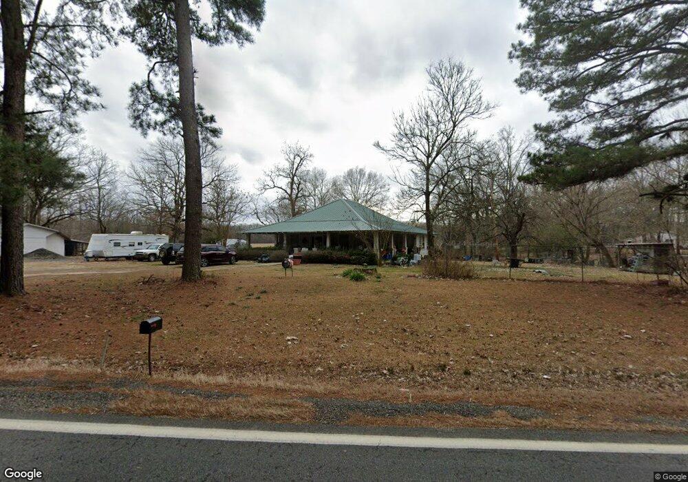
143 Highway 53 N Gurdon, AR 71743
Estimated Value: $86,766 - $171,000
--
Bed
1
Bath
1,744
Sq Ft
$82/Sq Ft
Est. Value
About This Home
This home is located at 143 Highway 53 N, Gurdon, AR 71743 and is currently estimated at $143,442, approximately $82 per square foot. 143 Highway 53 N is a home located in Clark County with nearby schools including Gurdon Primary School, Cabe Middle School, and Gurdon High School.
Ownership History
Date
Name
Owned For
Owner Type
Purchase Details
Closed on
Nov 25, 2022
Sold by
Burroughs Charlotte
Bought by
Burroughs Charlotte
Current Estimated Value
Purchase Details
Closed on
Jun 18, 2018
Sold by
Clark County Sheriff & Collector
Bought by
Clark County Ar
Purchase Details
Closed on
Sep 27, 2004
Bought by
Nohse Rebecca Lynn
Purchase Details
Closed on
Feb 7, 2003
Bought by
Nohse Becky
Purchase Details
Closed on
Dec 30, 1999
Bought by
Nohse Rebecca Lynn
Create a Home Valuation Report for This Property
The Home Valuation Report is an in-depth analysis detailing your home's value as well as a comparison with similar homes in the area
Home Values in the Area
Average Home Value in this Area
Purchase History
| Date | Buyer | Sale Price | Title Company |
|---|---|---|---|
| Burroughs Charlotte | -- | -- | |
| Burroughs Charlotte | -- | None Listed On Document | |
| Clark County Ar | -- | None Available | |
| Nohse Rebecca Lynn | -- | -- | |
| Nohse Becky | -- | -- | |
| Bailey Harrison | -- | -- | |
| Nohse Rebecca Lynn | -- | -- |
Source: Public Records
Tax History Compared to Growth
Tax History
| Year | Tax Paid | Tax Assessment Tax Assessment Total Assessment is a certain percentage of the fair market value that is determined by local assessors to be the total taxable value of land and additions on the property. | Land | Improvement |
|---|---|---|---|---|
| 2024 | $628 | $12,530 | $1,680 | $10,850 |
| 2023 | $628 | $12,530 | $1,680 | $10,850 |
| 2022 | $540 | $12,530 | $1,680 | $10,850 |
| 2021 | $520 | $12,530 | $1,680 | $10,850 |
| 2020 | $477 | $12,530 | $1,680 | $10,850 |
| 2019 | $434 | $10,060 | $1,680 | $8,380 |
| 2018 | $429 | $10,060 | $1,680 | $8,380 |
| 2017 | $429 | $10,060 | $1,680 | $8,380 |
| 2016 | $429 | $10,060 | $1,680 | $8,380 |
| 2015 | $429 | $10,060 | $1,680 | $8,380 |
| 2014 | $431 | $10,110 | $1,680 | $8,430 |
Source: Public Records
Map
Nearby Homes
- TBD Hwy 67 S
- 313 W Miller St
- 7104 Highway 67 S
- 109 N 7th St
- 326 Arkansas 53
- 0000 Arkansas 53
- 110 S 10th St
- 51 South St
- 103 Stonegate Ct
- 1795 Bowen Hill Rd
- TBD Kansas Rd
- 000 Kansas Rd
- 236 Lockie Rd
- 845 Stevenson Rd
- 196 Stevenson Rd
- 602 Stevenson Rd
- 505 Stevenson Rd
- 58 Dodgen Rd
- 652 Center Point
- TBD Hwy 67
- 129 Highway 53 N
- 181 Highway 53 N
- 0 Highway 53 Unit 17008331
- 93 Highway 53 N
- 204 Highway 53 N
- 25 Highway 53 N
- 19 Highway 53 N
- 49 Clarence Rd
- 1306 N Elm St
- 0 Clarence Rd
- 43 Clarence Rd
- 1312 N Elm St
- 300 Highway 53 N
- 805 N Elm St
- 34 Brewer Rd
- 326 Highway 53 N
- 332 Highway 53 N
- 100 Potter Rd
- 710 N Elm St
- 1002 N Elm St