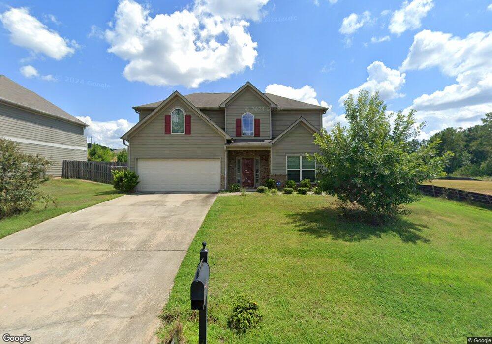
1430 Antietam Dr Columbus, GA 31907
Eastern Columbus NeighborhoodEstimated Value: $276,000 - $289,000
4
Beds
3
Baths
2,496
Sq Ft
$113/Sq Ft
Est. Value
About This Home
This home is located at 1430 Antietam Dr, Columbus, GA 31907 and is currently estimated at $282,396, approximately $113 per square foot. 1430 Antietam Dr is a home with nearby schools including St. Mary's Road Magnet Academy, East Columbus Magnet Academy, and Spencer High School.
Ownership History
Date
Name
Owned For
Owner Type
Purchase Details
Closed on
May 31, 2011
Sold by
Grayhawk Homes Inc
Bought by
Walker Robert
Current Estimated Value
Home Financials for this Owner
Home Financials are based on the most recent Mortgage that was taken out on this home.
Original Mortgage
$169,008
Outstanding Balance
$116,947
Interest Rate
4.71%
Mortgage Type
VA
Estimated Equity
$165,449
Create a Home Valuation Report for This Property
The Home Valuation Report is an in-depth analysis detailing your home's value as well as a comparison with similar homes in the area
Home Values in the Area
Average Home Value in this Area
Purchase History
| Date | Buyer | Sale Price | Title Company |
|---|---|---|---|
| Walker Robert | $169,008 | -- | |
| Grayhawk Homes Inc | -- | -- |
Source: Public Records
Mortgage History
| Date | Status | Borrower | Loan Amount |
|---|---|---|---|
| Open | Grayhawk Homes Inc | $169,008 | |
| Closed | Walker Robert | $169,008 |
Source: Public Records
Tax History Compared to Growth
Tax History
| Year | Tax Paid | Tax Assessment Tax Assessment Total Assessment is a certain percentage of the fair market value that is determined by local assessors to be the total taxable value of land and additions on the property. | Land | Improvement |
|---|---|---|---|---|
| 2025 | $2,130 | $107,228 | $12,004 | $95,224 |
| 2024 | $213 | $107,228 | $12,004 | $95,224 |
| 2023 | $1,448 | $107,228 | $12,004 | $95,224 |
| 2022 | $2,220 | $77,756 | $12,004 | $65,752 |
| 2021 | $2,214 | $71,496 | $12,004 | $59,492 |
| 2020 | $2,214 | $71,496 | $12,004 | $59,492 |
| 2019 | $2,223 | $71,496 | $12,004 | $59,492 |
| 2018 | $2,223 | $71,496 | $12,004 | $59,492 |
| 2017 | $2,232 | $71,496 | $12,004 | $59,492 |
| 2016 | $2,241 | $67,604 | $13,600 | $54,004 |
| 2015 | $2,245 | $67,604 | $13,600 | $54,004 |
| 2014 | $2,248 | $67,604 | $13,600 | $54,004 |
| 2013 | -- | $67,604 | $13,600 | $54,004 |
Source: Public Records
Map
Nearby Homes
- 5116 Magazine Ln
- 5109 Lexington Ln
- 1225 Rowell St
- 5090 Lexington Ln
- 1025 Belmar St
- 1210 Bunker Hill Rd
- 1238 Brandywine Dr
- 1425 Staunton Dr
- 5219 Argonne Dr
- 5310 Stoney Point Rd
- 1509 Bowie Ave
- 4718 Velpoe Dr
- 5336 Gettysburg Way
- 4939 Aaron Dr
- 849 Bunker Hill Rd
- 4831 Toney Dr
- 1340 Bunker Ridge Ln
- 811 Pheasant Loop
- 4581 Dawn Ct
- 1513 Alamo Dr
- 1424 Antietam Dr
- 1433 Antietam Dr
- 1418 Antietam Dr
- 1427 Antietam Dr
- 1412 Antietam Dr
- 1406 Antietam Dr
- 1529 Lexington Lake Dr
- 1409 Antietam Dr
- 1535 Lexington Lake Dr
- 1400 Antietam Dr
- 1403 Antietam Dr
- 1541 Lexington Lake Dr
- 5089 Magazine Ln
- 5095 Magazine Ln
- 5101 Magazine Ln
- 1394 Antietam Dr
- 5107 Magazine Ln
- 1547 Lexington Lake Dr
- 1397 Antietam Dr
- 5113 Magazine Ln