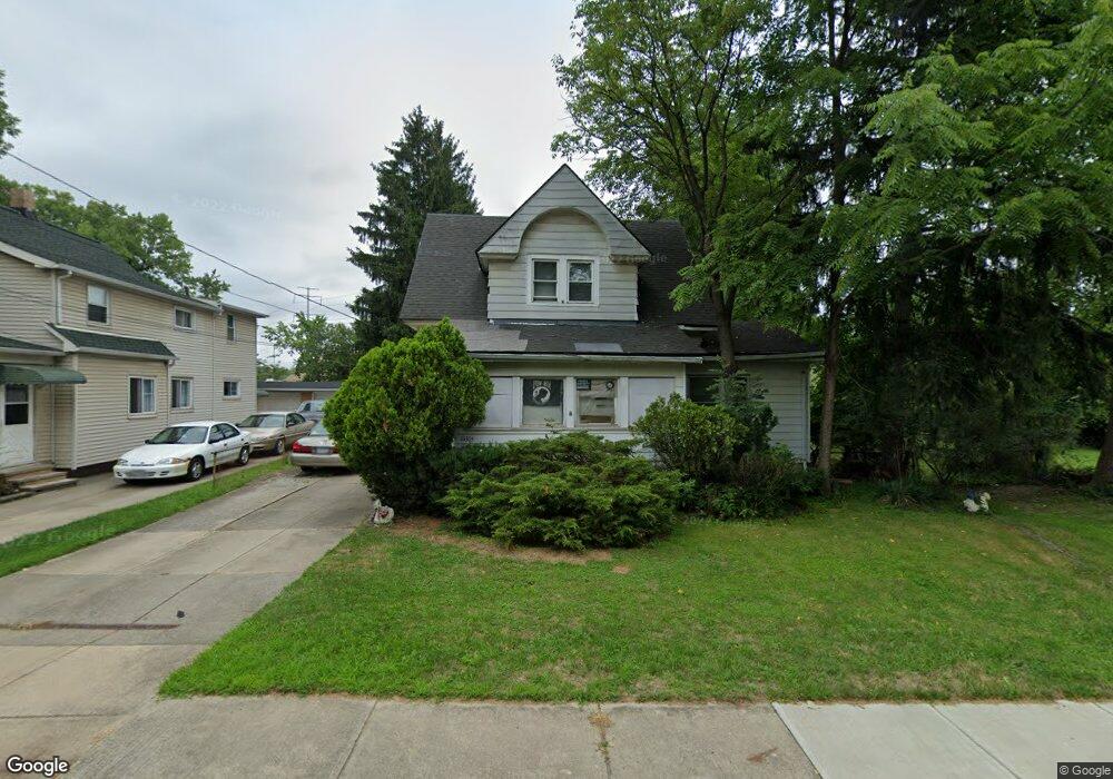
14305 Maple Ave Maple Heights, OH 44137
Estimated Value: $112,000 - $141,000
3
Beds
1
Bath
1,182
Sq Ft
$107/Sq Ft
Est. Value
About This Home
This home is located at 14305 Maple Ave, Maple Heights, OH 44137 and is currently estimated at $126,274, approximately $106 per square foot. 14305 Maple Ave is a home located in Cuyahoga County with nearby schools including Abraham Lincoln Elementary School, Rockside/ J.F. Kennedy School, and Barack Obama School.
Ownership History
Date
Name
Owned For
Owner Type
Purchase Details
Closed on
May 22, 2003
Sold by
Rell Christine A and Rell Carl C
Bought by
Depasquale Marianne
Current Estimated Value
Purchase Details
Closed on
Sep 13, 1988
Sold by
Zargari Joseph and Zargari Beatrice
Bought by
Rell Christine A
Purchase Details
Closed on
Oct 11, 1983
Sold by
Zargari Joseph and B R
Bought by
Zargari Joseph and Zargari Beatrice
Purchase Details
Closed on
Jan 1, 1975
Bought by
Zargari Joseph and B R
Create a Home Valuation Report for This Property
The Home Valuation Report is an in-depth analysis detailing your home's value as well as a comparison with similar homes in the area
Home Values in the Area
Average Home Value in this Area
Purchase History
| Date | Buyer | Sale Price | Title Company |
|---|---|---|---|
| Depasquale Marianne | -- | -- | |
| Rell Christine A | $36,000 | -- | |
| Zargari Joseph | -- | -- | |
| Zargari Joseph | -- | -- |
Source: Public Records
Tax History
| Year | Tax Paid | Tax Assessment Tax Assessment Total Assessment is a certain percentage of the fair market value that is determined by local assessors to be the total taxable value of land and additions on the property. | Land | Improvement |
|---|---|---|---|---|
| 2025 | $3,158 | $38,465 | $9,590 | $28,875 |
| 2024 | $3,504 | $38,465 | $9,590 | $28,875 |
| 2023 | $2,085 | $18,380 | $5,640 | $12,740 |
| 2022 | $2,078 | $18,380 | $5,640 | $12,740 |
| 2021 | $2,207 | $18,380 | $5,640 | $12,740 |
| 2020 | $1,904 | $13,930 | $4,270 | $9,660 |
| 2019 | $1,889 | $39,800 | $12,200 | $27,600 |
| 2018 | $1,878 | $13,930 | $4,270 | $9,660 |
| 2017 | $2,109 | $15,760 | $5,290 | $10,470 |
| 2016 | $2,037 | $15,760 | $5,290 | $10,470 |
| 2015 | $2,962 | $15,760 | $5,290 | $10,470 |
| 2014 | $2,962 | $16,240 | $5,460 | $10,780 |
Source: Public Records
Map
Nearby Homes
- 14510 Granger Rd
- 14512 Granger Rd
- 15264 Broadway Ave
- 5270 E 135th St
- 13600 Royal Blvd
- 13801 Bangor Ave
- 13417 Granger Rd
- 4955 E 141st St
- 5408 Roland Dr
- 5137 Miller Ave
- 5380 E 131st St
- 16029 Friend Ave
- 13009 Willard Ave
- 16101 Raymond St
- 13019 Darlington Ave
- 16174 Friend Ave
- 12913 Darlington Ave
- 13116 Oak Park Blvd
- 4816 E 135th St
- 13206 Shady Oak Blvd
- 14301 Maple Ave
- 14221 Maple Ave
- 14309 Maple Ave
- 14275 Maple Ave
- 14317 Maple Ave
- 5190 Beech Ave
- 5194 Beech Ave
- 14323 Maple Ave
- 5198 Beech Ave
- 5202 Beech Ave
- 14306 Maple Ave
- 14331 Maple Ave
- 5206 Beech Ave
- 14335 Maple Ave
- 14336 Maple Ave
- 5210 Beech Ave
- 14339 Maple Ave
- 5212 Beech Ave
- 14413 Elm St
- 5223 Forest Ave
Your Personal Tour Guide
Ask me questions while you tour the home.