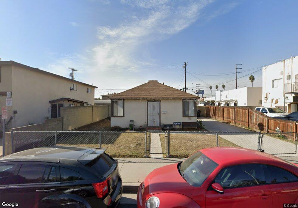
14315 Alburtis Ave Norwalk, CA 90650
Estimated Value: $607,149 - $731,000
2
Beds
1
Bath
576
Sq Ft
$1,163/Sq Ft
Est. Value
About This Home
This home is located at 14315 Alburtis Ave, Norwalk, CA 90650 and is currently estimated at $670,037, approximately $1,163 per square foot. 14315 Alburtis Ave is a home located in Los Angeles County with nearby schools including John H. Nuffer Elementary School, Los Alisos Middle School, and Norwalk High School.
Ownership History
Date
Name
Owned For
Owner Type
Purchase Details
Closed on
Oct 29, 1993
Sold by
Poff Thomas M and Poff Bonnie Mae
Bought by
Poff Thomas M
Current Estimated Value
Purchase Details
Closed on
Aug 26, 1993
Sold by
Poff Thomas M and Poff Bonnie Mae
Bought by
Poff Thomas M
Home Financials for this Owner
Home Financials are based on the most recent Mortgage that was taken out on this home.
Original Mortgage
$84,700
Interest Rate
7.2%
Create a Home Valuation Report for This Property
The Home Valuation Report is an in-depth analysis detailing your home's value as well as a comparison with similar homes in the area
Home Values in the Area
Average Home Value in this Area
Purchase History
| Date | Buyer | Sale Price | Title Company |
|---|---|---|---|
| Poff Thomas M | -- | None Available | |
| Poff Thomas M | -- | Cal Counties Title Company |
Source: Public Records
Mortgage History
| Date | Status | Borrower | Loan Amount |
|---|---|---|---|
| Closed | Poff Thomas M | $84,700 |
Source: Public Records
Tax History Compared to Growth
Tax History
| Year | Tax Paid | Tax Assessment Tax Assessment Total Assessment is a certain percentage of the fair market value that is determined by local assessors to be the total taxable value of land and additions on the property. | Land | Improvement |
|---|---|---|---|---|
| 2025 | $2,525 | $163,220 | $91,407 | $71,813 |
| 2024 | $2,525 | $160,020 | $89,615 | $70,405 |
| 2023 | $2,449 | $156,883 | $87,858 | $69,025 |
| 2022 | $2,407 | $153,808 | $86,136 | $67,672 |
| 2021 | $2,374 | $150,794 | $84,448 | $66,346 |
| 2019 | $2,312 | $146,324 | $81,945 | $64,379 |
| 2018 | $2,127 | $143,456 | $80,339 | $63,117 |
| 2016 | $2,036 | $137,887 | $77,220 | $60,667 |
| 2015 | $2,017 | $135,817 | $76,061 | $59,756 |
| 2014 | $1,895 | $133,158 | $74,572 | $58,586 |
Source: Public Records
Map
Nearby Homes
- 14411 Corby Ave
- 13918 Flallon Ave
- 12020 Orange St Unit A
- 14503 Elaine Ave
- 13623 Roseton Ave
- 12043 Sycamore St
- 13709 Clarkdale Ave Unit A
- 11712 Ferina St
- 12125 Foster Rd Unit 1
- 11408 Foster Rd
- 11343 Highdale St
- 15316 Flallon Ave
- 12209 Rosecrans Ave
- 12112 Abingdon St
- 11457 Maza St
- 14602 Thornlake Ave
- 12012 Sproul St Unit 1/2
- 12235 Pine St Unit 5
- 12161 Firestone Blvd
- 15510 Pioneer Blvd
- 14321 Alburtis Ave
- 11642 Rosecrans Ave
- 11642 Rosecrans Ave Unit 11642
- 14323 Alburtis Ave
- 14312 Flallon Ave
- 11644 Rosecrans Ave
- 11646 Rosecrans Ave
- 14316 Flallon Ave
- 14329 Alburtis Ave
- 14322 Flallon Ave
- 14314 Alburtis Ave
- 14316 Alburtis Ave
- 14312 Alburtis Ave Unit 28
- 14318 Alburtis Ave
- 14310 Alburtis Ave
- 14328 Flallon Ave
- 14335 Alburtis Ave
- 14332 Flallon Ave
- 14339 Alburtis Ave
- 14338 Flallon Ave