Estimated Value: $119,000 - $183,000
3
Beds
1
Bath
1,072
Sq Ft
$146/Sq Ft
Est. Value
About This Home
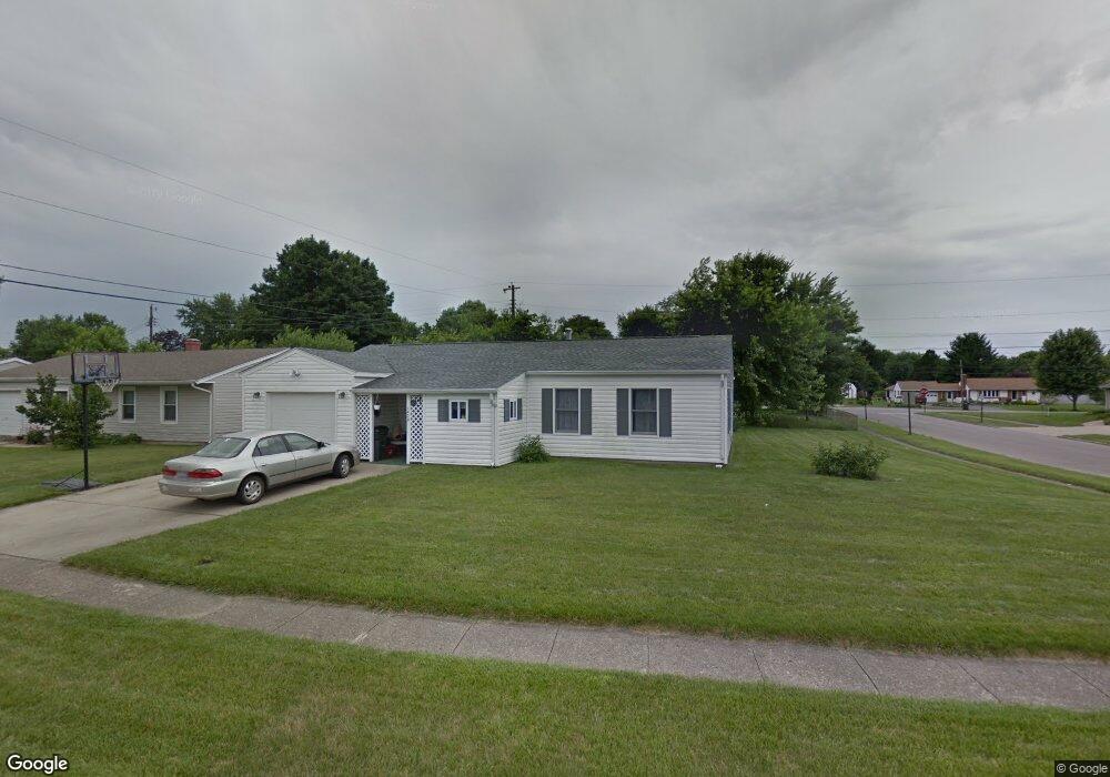
This home is located at 1439 Omard Dr, Xenia, OH 45385 and is currently estimated at $157,008, approximately $146 per square foot. 1439 Omard Dr is a home located in Greene County with nearby schools including Xenia High School, Summit Academy Community School for Alternative Learners - Xenia, and Legacy Christian Academy.
Ownership History
Date
Name
Owned For
Owner Type
Purchase Details
Closed on
May 5, 2020
Sold by
Hill Patricia M
Bought by
Hill Robert H
Current Estimated Value
Purchase Details
Closed on
Mar 12, 2014
Sold by
Hill Robert H
Bought by
Hill Ii Robert H and Hill Patricia M
Purchase Details
Closed on
Dec 24, 2011
Sold by
Hill Martha T
Bought by
Hill Ii Robert H
Purchase Details
Closed on
Jul 5, 2011
Sold by
Perkins Linda Ann and Perkins Linda A
Bought by
Hill Martha T and Martha T Hill Revocable Living Trust
Purchase Details
Closed on
Jul 26, 2010
Sold by
Perkins Rodney P
Bought by
Perkins Michael E
Purchase Details
Closed on
Nov 15, 2005
Sold by
Hook Mildred E
Bought by
Hook Mildred E and Perkins Rodney P
Create a Home Valuation Report for This Property
The Home Valuation Report is an in-depth analysis detailing your home's value as well as a comparison with similar homes in the area
Home Values in the Area
Average Home Value in this Area
Purchase History
| Date | Buyer | Sale Price | Title Company |
|---|---|---|---|
| Hill Robert H | -- | None Available | |
| Hill Ii Robert H | -- | None Available | |
| Hill Ii Robert H | -- | Attorney | |
| Hill Martha T | $50,000 | None Available | |
| Perkins Michael E | $25,000 | None Available | |
| Perkins Rodney P | -- | None Available | |
| Hook Mildred E | -- | -- | |
| Hook Mildred E | -- | -- |
Source: Public Records
Tax History Compared to Growth
Tax History
| Year | Tax Paid | Tax Assessment Tax Assessment Total Assessment is a certain percentage of the fair market value that is determined by local assessors to be the total taxable value of land and additions on the property. | Land | Improvement |
|---|---|---|---|---|
| 2024 | $1,748 | $40,860 | $10,290 | $30,570 |
| 2023 | $1,748 | $40,860 | $10,290 | $30,570 |
| 2022 | $1,429 | $28,490 | $7,350 | $21,140 |
| 2021 | $1,448 | $28,490 | $7,350 | $21,140 |
| 2020 | $1,388 | $28,490 | $7,350 | $21,140 |
| 2019 | $1,131 | $21,860 | $5,250 | $16,610 |
| 2018 | $1,136 | $21,860 | $5,250 | $16,610 |
| 2017 | $1,075 | $21,860 | $5,250 | $16,610 |
| 2016 | $1,076 | $20,320 | $5,250 | $15,070 |
| 2015 | $1,079 | $20,320 | $5,250 | $15,070 |
| 2014 | $1,033 | $20,320 | $5,250 | $15,070 |
Source: Public Records
Map
Nearby Homes
- 1351 Omard Dr
- 343 Sheelin Rd
- 1391 June Dr
- 1283 June Dr
- 1233 June Dr
- 1223 June Dr
- 912 Omard Dr
- 883 Omard Dr
- 509 Antrim Rd
- 1342 Kylemore Dr
- 121 S Progress Dr
- 1144 Rockwell Dr
- 1568 Cheyenne Dr
- Harmony Plan at Grandstone Trace
- Newcastle Plan at Grandstone Trace
- Pendleton Plan at Grandstone Trace
- Bellamy Plan at Grandstone Trace
- Chatham Plan at Grandstone Trace
- 613 N West St
- 523 Hollywood Blvd