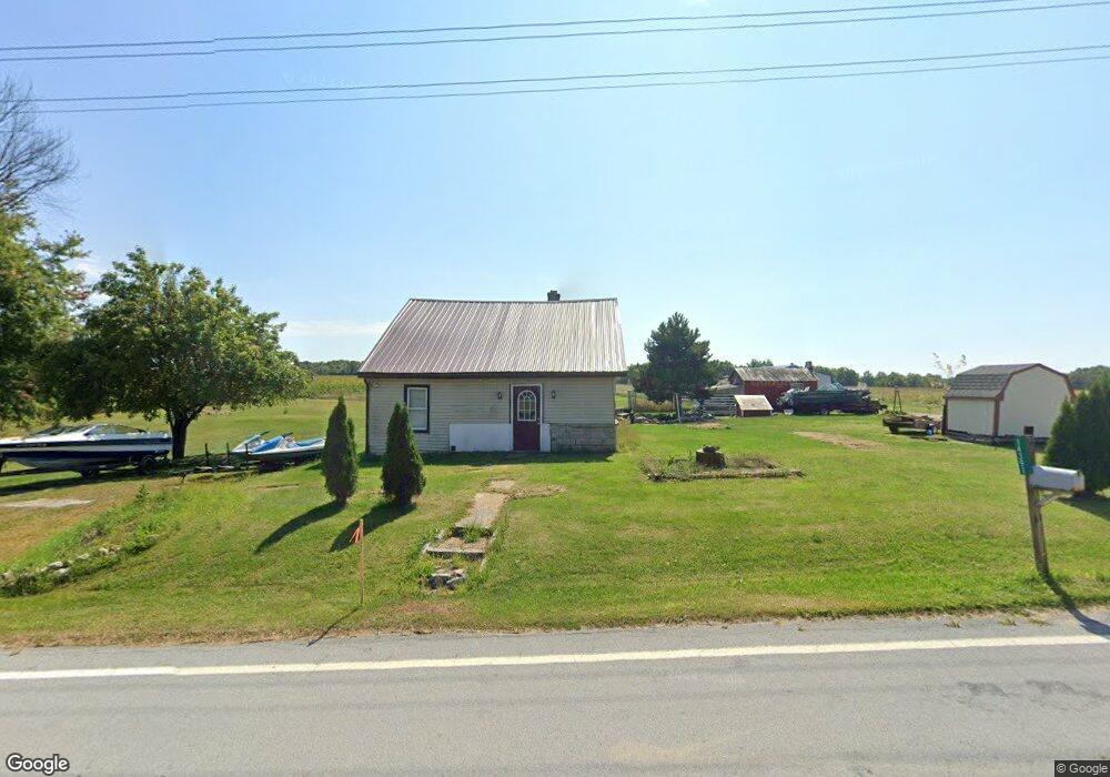
14391 State Highway 294 Upper Sandusky, OH 43351
Estimated Value: $95,823 - $208,000
2
Beds
1
Bath
705
Sq Ft
$211/Sq Ft
Est. Value
About This Home
This home is located at 14391 State Highway 294, Upper Sandusky, OH 43351 and is currently estimated at $148,956, approximately $211 per square foot. 14391 State Highway 294 is a home with nearby schools including Upper Sandusky High School.
Ownership History
Date
Name
Owned For
Owner Type
Purchase Details
Closed on
Mar 13, 2019
Sold by
Getz Mary Evelyn and Getz Walter J
Bought by
Clark Jeremy David
Current Estimated Value
Purchase Details
Closed on
Aug 21, 2009
Sold by
Graham Mary Evelyn and Getz Walter J
Bought by
Getz Mary Evelyn and Clark Jeremy David
Create a Home Valuation Report for This Property
The Home Valuation Report is an in-depth analysis detailing your home's value as well as a comparison with similar homes in the area
Home Values in the Area
Average Home Value in this Area
Purchase History
| Date | Buyer | Sale Price | Title Company |
|---|---|---|---|
| Clark Jeremy David | -- | None Available | |
| Getz Mary Evelyn | -- | None Available |
Source: Public Records
Tax History Compared to Growth
Tax History
| Year | Tax Paid | Tax Assessment Tax Assessment Total Assessment is a certain percentage of the fair market value that is determined by local assessors to be the total taxable value of land and additions on the property. | Land | Improvement |
|---|---|---|---|---|
| 2024 | $752 | $24,740 | $2,800 | $21,940 |
| 2023 | $752 | $24,740 | $2,800 | $21,940 |
| 2022 | $752 | $22,490 | $2,540 | $19,950 |
| 2021 | $715 | $22,490 | $2,540 | $19,950 |
| 2020 | $714 | $22,490 | $2,540 | $19,950 |
| 2019 | $713 | $22,490 | $2,540 | $19,950 |
| 2018 | $424 | $13,660 | $2,220 | $11,440 |
| 2017 | $431 | $13,660 | $2,220 | $11,440 |
| 2016 | -- | $13,660 | $2,220 | $11,440 |
| 2015 | -- | $13,480 | $2,220 | $11,260 |
| 2014 | -- | $13,480 | $2,220 | $11,260 |
| 2013 | -- | $13,480 | $2,220 | $11,260 |
Source: Public Records
Map
Nearby Homes
- 18205 County Highway 96
- 14319 County Highway 64
- 14471 Township Highway 71
- 16877 State Route 67
- 15418 Ohio 37
- 21109 State Route 67
- 00 Osbun Rd Unit Lot 6
- 0 Osbun Rd Unit Lot 27 225032274
- 11650 Township Highway 103
- 23385 Township Road 126
- 7900 State Highway 294
- 3132 Decliff Rd N
- 3096 Decliff Rd N
- 10483 Township Road 225
- 381 & 383 W Johnson St
- US 30 Sr 23
- 203 203 1/2 E Crawford St
- 221&221 1/2 S 7th St
- 0 State Highway 53 Unit 6132082
- 7367 Wyandot St
- 14392 State Highway 294
- 14364 Ohio 294
- 14364 State Highway 294 Unit 294
- 14364 State Highway 294
- 14346 State Highway 294
- 14312 State Highway 294
- 14667 Ohio 294
- 14667 State Highway 294
- 17287 Township Highway 96
- 13977 State Highway 294
- 13943 State Highway 294
- 13909 Ohio 294
- 13909 State Highway 294
- 13781 State Highway 294
- 14982 State Highway 294
- 17113 Township Highway 96
- 18248 State Highway 67
- 17157 Township Highway 97
- 13769 State Highway 294
- 17658 County Highway 96