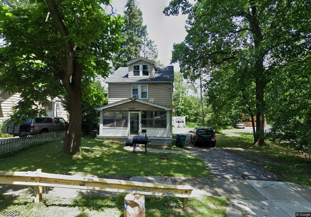
14399 Maple Ave Maple Heights, OH 44137
Estimated Value: $92,000 - $136,000
3
Beds
1
Bath
1,120
Sq Ft
$103/Sq Ft
Est. Value
About This Home
This home is located at 14399 Maple Ave, Maple Heights, OH 44137 and is currently estimated at $115,758, approximately $103 per square foot. 14399 Maple Ave is a home located in Cuyahoga County with nearby schools including Abraham Lincoln Elementary School, Rockside/ J.F. Kennedy School, and Barack Obama School.
Ownership History
Date
Name
Owned For
Owner Type
Purchase Details
Closed on
Sep 18, 2009
Sold by
Secretary Of Housing & Urban Development
Bought by
Adp Properties Llc
Current Estimated Value
Purchase Details
Closed on
Apr 2, 2007
Sold by
Johnson Janessa N
Bought by
Hud
Purchase Details
Closed on
Nov 12, 1999
Sold by
Estate Of Jack F Wall
Bought by
Wall Dale W
Purchase Details
Closed on
Mar 26, 1981
Sold by
Wall Jack F
Bought by
Jack F Wall
Purchase Details
Closed on
Jan 1, 1975
Bought by
Wall Jack F
Create a Home Valuation Report for This Property
The Home Valuation Report is an in-depth analysis detailing your home's value as well as a comparison with similar homes in the area
Home Values in the Area
Average Home Value in this Area
Purchase History
| Date | Buyer | Sale Price | Title Company |
|---|---|---|---|
| Adp Properties Llc | $3,500 | Lakeside Title & Escrow Agen | |
| Hud | $50,000 | Attorney | |
| Wall Dale W | -- | -- | |
| Jack F Wall | -- | -- | |
| Wall Jack F | -- | -- |
Source: Public Records
Tax History
| Year | Tax Paid | Tax Assessment Tax Assessment Total Assessment is a certain percentage of the fair market value that is determined by local assessors to be the total taxable value of land and additions on the property. | Land | Improvement |
|---|---|---|---|---|
| 2025 | $3,093 | $37,485 | $6,370 | $31,115 |
| 2024 | $3,441 | $37,485 | $6,370 | $31,115 |
| 2023 | $2,405 | $21,990 | $3,750 | $18,240 |
| 2022 | $2,397 | $21,980 | $3,750 | $18,240 |
| 2021 | $2,557 | $21,980 | $3,750 | $18,240 |
| 2020 | $2,185 | $16,660 | $2,840 | $13,830 |
| 2019 | $2,174 | $47,600 | $8,100 | $39,500 |
| 2018 | $2,163 | $16,660 | $2,840 | $13,830 |
| 2017 | $2,168 | $16,350 | $3,570 | $12,780 |
| 2016 | $2,098 | $16,350 | $3,570 | $12,780 |
| 2015 | $1,988 | $16,350 | $3,570 | $12,780 |
| 2014 | $1,988 | $16,840 | $3,680 | $13,160 |
Source: Public Records
Map
Nearby Homes
- 14510 Granger Rd
- 14512 Granger Rd
- 15264 Broadway Ave
- 5137 Miller Ave
- 13801 Bangor Ave
- 13600 Royal Blvd
- 5408 Roland Dr
- 5270 E 135th St
- 4955 E 141st St
- 16029 Friend Ave
- 16101 Raymond St
- 16174 Friend Ave
- 5380 E 131st St
- 5370 Lee Rd Unit 302
- 16241 Glenburn Ave
- 13009 Willard Ave
- 5382 Lee Rd Unit 102
- 13019 Darlington Ave
- 16351 Glenburn Ave
- 5062 Lee Rd
- 14355 Maple Ave
- 14403 Maple Ave
- 14351 Maple Ave
- 14405 Maple Ave
- 14428 Elm St
- 14426 Elm St
- 14408 Maple Ave
- 14339 Maple Ave
- 14411 Maple Ave
- 14425 Elm St
- 14417 Maple Ave
- 14335 Maple Ave
- 14416 Elm St
- 14421 Maple Ave
- 14331 Maple Ave
- 14515 William St
- 14413 Elm St
- 14336 Maple Ave
- 14414 Elm St
- 14425 Maple Ave
Your Personal Tour Guide
Ask me questions while you tour the home.