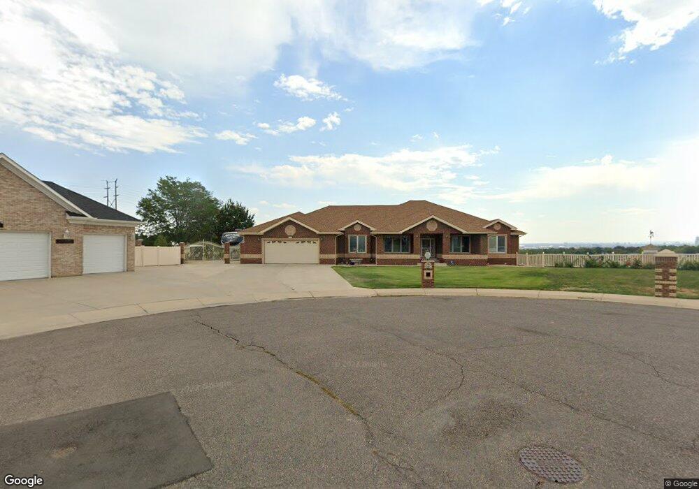
1440 Kokai Cir Denver, CO 80221
Sherrelwood NeighborhoodEstimated Value: $489,000 - $1,150,061
4
Beds
4
Baths
2,910
Sq Ft
$305/Sq Ft
Est. Value
About This Home
This home is located at 1440 Kokai Cir, Denver, CO 80221 and is currently estimated at $888,354, approximately $305 per square foot. 1440 Kokai Cir is a home located in Adams County with nearby schools including Sherrelwood Elementary School, Iver C. Ranum Middle School, and Westminster High School.
Ownership History
Date
Name
Owned For
Owner Type
Purchase Details
Closed on
Sep 17, 2020
Sold by
Kokai Anna
Bought by
The Kokai Family Trust
Current Estimated Value
Purchase Details
Closed on
Apr 16, 2002
Sold by
Kokai Miklos and Kokai Anna
Bought by
Kokai Miklos and Kokai Anna
Purchase Details
Closed on
Dec 13, 1999
Sold by
Kokai Frank and Kokai Jane
Bought by
Kokai Miklos and Kokai Anna
Home Financials for this Owner
Home Financials are based on the most recent Mortgage that was taken out on this home.
Original Mortgage
$150,000
Interest Rate
7.86%
Mortgage Type
Unknown
Purchase Details
Closed on
Dec 10, 1999
Sold by
N B Q Construction Inc
Bought by
Kokai Miklos and Kokai Anna
Home Financials for this Owner
Home Financials are based on the most recent Mortgage that was taken out on this home.
Original Mortgage
$150,000
Interest Rate
7.86%
Mortgage Type
Unknown
Create a Home Valuation Report for This Property
The Home Valuation Report is an in-depth analysis detailing your home's value as well as a comparison with similar homes in the area
Home Values in the Area
Average Home Value in this Area
Purchase History
| Date | Buyer | Sale Price | Title Company |
|---|---|---|---|
| The Kokai Family Trust | -- | None Available | |
| Kokai Miklos | -- | -- | |
| Kokai Miklos | -- | Land Title | |
| Kokai Miklos | -- | Land Title |
Source: Public Records
Mortgage History
| Date | Status | Borrower | Loan Amount |
|---|---|---|---|
| Closed | Kokai Miklos | $150,000 | |
| Closed | Kokai Miklos | $112,000 |
Source: Public Records
Tax History Compared to Growth
Tax History
| Year | Tax Paid | Tax Assessment Tax Assessment Total Assessment is a certain percentage of the fair market value that is determined by local assessors to be the total taxable value of land and additions on the property. | Land | Improvement |
|---|---|---|---|---|
| 2024 | $7,500 | $59,000 | $14,840 | $44,160 |
| 2023 | $7,458 | $70,080 | $9,720 | $60,360 |
| 2022 | $4,782 | $46,220 | $9,990 | $36,230 |
| 2021 | $4,782 | $46,220 | $9,990 | $36,230 |
| 2020 | $4,704 | $46,500 | $10,280 | $36,220 |
| 2019 | $4,693 | $46,500 | $10,280 | $36,220 |
| 2018 | $4,581 | $45,400 | $10,350 | $35,050 |
| 2017 | $4,002 | $45,400 | $10,350 | $35,050 |
| 2016 | $4,075 | $44,860 | $9,250 | $35,610 |
| 2015 | $4,072 | $36,910 | $7,610 | $29,300 |
| 2014 | $5,284 | $46,370 | $6,280 | $40,090 |
Source: Public Records
Map
Nearby Homes
- 7973 Greenwood Blvd
- 7956 Osage St
- 1321 Marigold Dr
- 7961 Granada Rd
- 1041 Marigold Dr
- 7883 Greenwood Blvd
- 8247 Vanguard Dr
- 8188 Pecos Way
- 1390 W 78th Cir
- 8338 Charles Way
- 7875 Cyd Dr
- 8324 Mitze Way
- 1285 Elder St
- 1303 Lipan Dr
- 7918 Tejon St
- 1325 Elder St
- 8353 Adams Way
- 1242 Elder St
- 7733 Navajo St
- 8384 Mitze Way
- 1435 Kokai Cir
- 1460 Kokai Cir
- 8120 Albert Ct
- 8130 Albert Ct
- 1455 Kokai Cir
- 1475 Kokai Cir
- 1480 Kokai Cir
- 8121 Albert Ct
- 8150 Albert Ct
- 1484 Lofton Ct
- 8141 Albert Ct
- 1459 Lofton Ct
- 1490 Kokai Cir
- 1479 Lofton Ct
- 8160 Albert Ct
- 1500 Kokai Cir
- 8161 Albert Ct
- 1456 W 81st Place
- 1476 W 81st Place
- 1489 Lofton Ct